


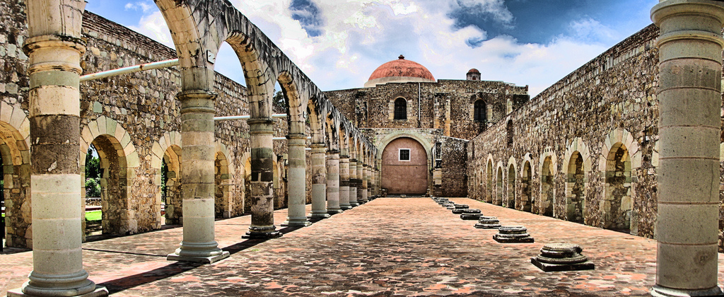


Cuilápam de Guerrero, Mexico
Cuilápam de Guerrero is a town of 12,360 people in Oaxaca, Mexico.
Why visit Cuilápam de Guerrero
Townapedia lists 4 museums and landmarks, 2 parks and trails, 5 places to eat and 1 place to stay in and around town.
Highlights include Monte Albán and Templo Dominico y Ex-Convento de Santiago Apóstol.
Weather in Cuilápam de Guerrero
Forecast from MET Norway (CC BY 4.0). Full forecast
About Cuilápam de Guerrero
Cuilapan de Guerrero is a town and municipality located in the central valley region of Oaxaca in southern Mexico. It is 10 kilometres (6.2 mi) to the south of the capital city of Oaxaca on the road leading to Villa de Zaachila, and is in the Centro District in the Valles Centrales region.
From the Wikipedia article Cuilapan de Guerrero (this version), under CC BY-SA 4.0.
Museums and landmarks4
Monte Albán
Monument and historic site · 5.5 km
Pre-Columbian archaeological site in Mexico
Templo Dominico y Ex-Convento de Santiago Apóstol
Monument and historic site



Parks, trails and playgrounds2

Balneario La Gloria
Sports field and stadium · 1.2 km
Calle Guerrero

Restaurants and cafes5



Where to stay1

History
The Cuilapan area has been settled by humans since 1500 BCE with a sedentary village established by 500 BCE. These sedentary peoples developed activities such as weaving, pottery and stonemasonry, with permanent houses, ceremonial structures and tombs. The society here grew and stratified over time and eventually a simple writing system came into existence. Cuilapan developed as an independent city state until the rise of Monte Albán, which came into dominance because it provided a refuge in a defensible location. During this time, Cuilapan was one of the satellite cities of the dominion. Between 600 and 900 CE, Monte Albán declined and collapsed, allowing Cuilapan and others to become independent again. Excavations from this period show that Cuilapan gained prominence in the post Monte Albán period, but was not dominant over its neighbors and never reached the heights of the former dominion. At that time, Cuilapan was identifiable as a Zapotec city state. Later, in the post-classic period, this and other Zapotec cities would be overrun by the Mixtecs.
From the History section of Cuilapan de Guerrero on Wikipedia, under CC BY-SA 4.0.
Churches and places of worship5
Shopping4
Gas and EV charging1
Schools, colleges and libraries9
Escuela primaria General Lázaro Cárdenas
School · 2.4 km
Calle Santa Rosa, Oaxaca de Juárez
Escuela primaria Niños héroes de Chapultepec
School · 1.9 km
Calle Reforma, Oaxaca de Juárez
Healthcare11
Casa De Salud De La Colonia La Soledad
Clinic and pharmacy · 2.5 km
Calle Virgen de Guadalupe
Consultorio Médico
Clinic and pharmacy · 2.4 km
Calle San Francisco, Oaxaca de Juárez
Consultorio médico fundación Bets Ac
Clinic and pharmacy
Calle Francisco I. Madero, Cuilápam
Unidad De Salud Del Instituto Mexicano Del Seguro Social Oportunidades
Hospital
Calle Francisco I. Madero
Map of Cuilápam de Guerrero
42 places. The map loads OpenStreetMap tiles when you open it.
Getting there and nearby towns
Aeropuerto Internacional Xoxocotlán (OAX) is the nearest airport with scheduled flights listed in OpenStreetMap, 6 km away.
- Lomas de San Juan 2 km northeast, about 2 min by car
- Cruz Blanca 3 km northeast, about 3 min by car
- San Isidro Monjas 3 km east, about 3 min by car
- El Paraíso 3 km north, about 3 min by car
- San Francisco Javier 4 km north, about 4 min by car
- San Raymundo Jalpan 4 km southeast, about 4 min by car
- San Lucas Tlanichico 4 km southwest, about 4 min by car
- San Antonio Arrazola 5 km north, about 5 min by car
- Santa Cruz Xoxocotlán 6 km northeast, about 6 min by car
- Oaxaca 9 km northeast, about 9 min by car
Drive times are estimates from straight-line distance, not routes.
Local news
Headlines from INDB.
Reviews, tips and questions
Loading what members have shared...
Sources and licences
- GeoNames (CC BY 4.0): population, coordinates, regions and time zone
- OpenStreetMap contributors (ODbL 1.0): places, airports, map data
- Wikidata (CC0 1.0): elevation, founding date, time zone, website, landmarks and historic places
- Wikimedia Commons (see each image): photos
- Wikipedia (CC BY-SA 4.0): overview and history text
Photo credits
- Convento de Cuilapan, Fernando Solís, CC BY-SA 3.0
- Monte Albán archeological site, Oaxaca, Unknown author, CC BY-SA 3.0
- Santiago Apóstol Oaxaca, Nsaum75 ( talk ), CC BY-SA 3.0
- CultCenterCuilapam, AlejandroLinaresGarcia, CC BY-SA 4.0
- MuniPalCuilapam, AlejandroLinaresGarcia, CC BY-SA 4.0
- CloseDanzaPlumaCuilapam, AlejandroLinaresGarcia, CC BY-SA 4.0
- StatueDanzaFlores, AlejandroLinaresGarcia, CC BY-SA 4.0
- ViewComplexCuilapam2, AlejandroLinaresGarcia, CC BY-SA 4.0
- ViewComplexCuilapam, Thelmadatter, CC BY-SA 3.0
- MonasteryComplexCuilapam, AlejandroLinaresGarcia, CC BY-SA 4.0
- FacadeOpenChapelCuilapam, Thelmadatter, CC BY-SA 3.0
- FacadeOpenChapelCuilapam2, Thelmadatter, CC BY-SA 3.0
- UnfinishedArchesCuilapam, Thelmadatter, CC BY-SA 3.0
- ViewCuilapam1, Thelmadatter, CC BY-SA 3.0
- SideEntranceChapelCuilapam, Thelmadatter, CC BY-SA 3.0
- UnfinishedArchesCuilapam2, Thelmadatter, CC BY-SA 3.0
- HallCuilapam1, Thelmadatter, CC BY-SA 3.0
- ArchSupportsCuilapam, Thelmadatter, CC BY-SA 3.0
- WestSectionCuilapam, Thelmadatter, CC BY-SA 3.0
- ArcadeCuilapam, AlejandroLinaresGarcia, CC BY-SA 4.0
- CapitelInteriorExConventoDeCuilapam, DavidConFran, CC BY-SA 3.0
- FachadaExConventoSantiagoApostol, DavidConFran, CC BY-SA 3.0
- FachadaCapillaAbiertaExConventoSantiagoApostol, DavidConFran, CC BY-SA 3.0
- ExConventoSantiagoApostol, DavidConFran, CC BY-SA 3.0
- InteriorCapillaAbiertaExConventoSantiagoApostol, DavidConFran, CC BY-SA 3.0
- CruzAtrialExConventoSantiagoApostol, DavidConFran, CC BY-SA 3.0
- DetalleTequitquiExConventoSantiagoApostol, DavidConFran, CC BY-SA 3.0
- Desde ventana, Lsalgador82, CC BY-SA 3.0
- Ventanas costado y arbol, Lsalgador82, CC BY-SA 3.0
- Vetanas, Lsalgador82, CC BY-SA 3.0
- Fondo pintura pasillo, Lsalgador82, CC BY-SA 3.0
- Vista sin techo, Lsalgador82, CC BY-SA 3.0
- Base arco vista puerta, Lsalgador82, CC BY-SA 3.0
- Esquina patio, Lsalgador82, CC BY-SA 3.0
- Vista columnas, Lsalgador82, CC BY-SA 3.0
- Arcos parte trasera, Lsalgador82, CC BY-SA 3.0
- Vista general capilla abierta, Lsalgador82, CC BY-SA 3.0
- Techo escaleras, Lsalgador82, CC BY-SA 3.0
- Ventnas, Lsalgador82, CC BY-SA 3.0
- Pintura fondo muro, Lsalgador82, CC BY-SA 3.0
- Vista desde el fondo capilla abierta, Lsalgador82, CC BY-SA 3.0


Page built November 4, 2026. Spotted a mistake? Tell us or suggest a place.