


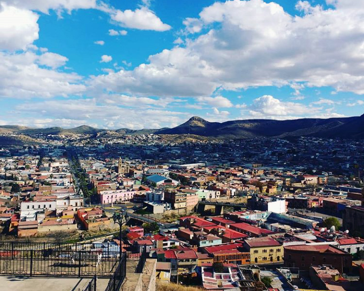


Hidalgo del Parral, Mexico
Hidalgo del Parral is a town of 104,836 people in Chihuahua, Mexico, founded in 1631.
Why visit Hidalgo del Parral
Townapedia lists 11 museums and landmarks, 15 parks and trails, 3 places to eat, 4 places to stay and 4 attractions in and around town.
Weather in Hidalgo del Parral
Forecast from MET Norway (CC BY 4.0). Full forecast
About Hidalgo del Parral
Hidalgo del Parral is a city and seat of the municipality of Hidalgo del Parral in the Mexican state of Chihuahua. It is located in the southern part of the state, 220 kilometres (140 mi) from the state capital, the city of Chihuahua, Chihuahua. As of 2015, the city of Hidalgo del Parral had a population of 109,510 inhabitants, while the metro area had a population of 129,688 inhabitants. During the colonial period the city was a significant supplier of silver to the Spanish empire and was known as San José del Parral.
From the Wikipedia article Parral, Chihuahua (this version), under CC BY-SA 4.0.
Travel tips from other travellers: Hidalgo del Parral on Wikivoyage (CC BY-SA 4.0).
Things to do4


Museums and landmarks11




Parks, trails and playgrounds15


3 more on the map.
Restaurants and cafes3



History
During the sixteenth and seventeenth centuries, Parral was once a bustling center for silver mining.
According to legend, Juan Rangel de Biezma came here in 1629, picked up a rock on the "Cerro la Prieta" (La Prieta Hill), licked it and proclaimed, "There is a mineral deposit here." This deposit produced silver for 340 years.
Despite legend, as early as 1567, the silver mines at Santa Barbara were established in the territory of the Conchos people. However, in 1631, a vast new silver strike was made in what is now southern Chihuahua. Later, in 1640, it was declared "Capital of the World of Silver" by monarch Philip IV of Spain, at the very height of the Spanish Empire, that included territories in Eastern Asia, Italy, and the Low Countries.
From the History section of Parral, Chihuahua on Wikipedia, under CC BY-SA 4.0.
Where to stay4
Churches and places of worship9
Shopping10
Gas and EV charging11
Schools, colleges and libraries7
Healthcare4
Hospital General de Zona, Medicina Familiar #23
Hospital · 1.6 km
Avenida Independencia
Map of Hidalgo del Parral
78 places. The map loads OpenStreetMap tiles when you open it.
Getting there and nearby towns
- San Francisco del Oro 20 km west, about 20 min by car
- Santa Bárbara 21 km southwest, about 21 min by car
- Mariano Matamoros 20 km southeast, about 20 min by car
- Talamantes 23 km east, about 23 min by car
- Valle de Ignacio Allende 27 km east, about 27 min by car
- Pueblito de Allende 34 km east, about 34 min by car
- José Esteban Coronado 55 km southeast, about 55 min by car
- Villa Ocampo 57 km south, about 57 min by car
- Valle de Zaragoza 60 km north, about 1 h by car
- Octaviano López 63 km east, about 1 h by car
Drive times are estimates from straight-line distance, not routes.
Local news
Headlines from INDB.
Reviews, tips and questions
Loading what members have shared...
Sources and licences
- GeoNames (CC BY 4.0): population, coordinates, regions and time zone
- OpenStreetMap contributors (ODbL 1.0): places, airports, map data
- Wikidata (CC0 1.0): elevation, founding date, time zone, website
- Wikimedia Commons (see each image): photos
- Wikipedia (CC BY-SA 4.0): overview and history text
Photo credits
- Centro en Hidalgo del Parral, MikSed, CC BY 4.0
- Panoramica de hidalgo del parral - panoramio, verdo_iglesias, CC BY-SA 3.0
- Parroquia San José en Hidalgo del Parral, MikSed, CC BY 4.0
- Vistas a Hidalgo del Parral, MikSed, CC BY 4.0
- Vista de Mina La Prieta, Sarawongb, CC BY 4.0
- Phemeranthus palmeri 411279794, Oscar C. González Martínez, CC BY-SA 4.0
- Serjania dissecta 411278543, Oscar González, CC BY-SA 4.0
- Coursetia pumila 431329294, Oscar C. González Martínez, CC BY-SA 4.0
- Coursetia pumila 431329366, Oscar C. González Martínez, CC BY-SA 4.0
- San José y mina la prieta - panoramio, verdo_iglesias, CC BY-SA 3.0


Page built November 4, 2026. Spotted a mistake? Tell us or suggest a place.