


Iztacalco, Mexico
Iztacalco is a town of 384,326 people in Mexico City, Mexico, founded in 1928.
Why visit Iztacalco
Townapedia lists 68 museums and landmarks, 75 parks and trails, 149 places to eat, 15 places to stay and 19 attractions in and around town.
Highlights include Centro de Capacitación Cinematográfica, Palace of Fine arts, Academy of San Carlos and Antimonumento +43.
Weather in Iztacalco
Forecast from MET Norway (CC BY 4.0). Full forecast
About Iztacalco
Iztacalco (Spanish: [istaˈkalko] ) is a borough (demarcación territorial) in Mexico City. It is located in the central-eastern area and it is the smallest of the city's boroughs. The area's history began in 1309 when the island of Iztacalco, in what was Lake Texcoco, was settled in 1309 by the Mexica who would later found Tenochtitlan, according to the Codex Xolotl. The island community would remain small and isolated through the colonial period, but drainage projects in the Valley of Mexico dried up the lake around it.
From the Wikipedia article Iztacalco (this version), under CC BY-SA 4.0.
Travel tips from other travellers: Iztacalco on Wikivoyage (CC BY-SA 4.0).
Things to do19

Centro de Capacitación Cinematográfica
School · 6.3 km
Film school in Mexico City

Palace of Fine arts
Cinema and theater · 6.4 km
Cultural centre in Mexico City

Royal and Pontifical University of Mexico
School · 5.6 km
Historic university in Mexico City (1551–1865)

Teatro de la Ciudad
Cinema and theater · 6.2 km
Theatre in Mexico City
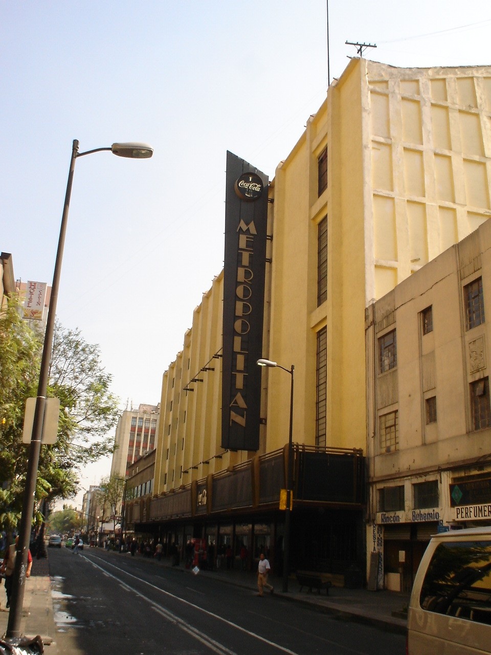
Teatro Metropólitan
Cinema and theater · 6.7 km
Music venue and theater in Mexico City, formerly a movie theater

Universidad Autónoma de la Ciudad de México
School · 6.7 km
University in Mexico

Universidad Autónoma Metropolitana Unidad Iztapalapa
School · 4.6 km
Campus of Universidad Autónoma Metropolitana

Universidad de la Comunicación
School · 6.9 km
University in Mexico City, Mexico

Universidad del Claustro de Sor Juana
School · 5.4 km
Mexican university

7 more on the map.
Museums and landmarks68

Academy of San Carlos
Museum · 5.3 km
First major art academy and the first art museum in the Americas

Antimonumento +43
Monument and historic site · 7.1 km
Memorial in Mexico City

Borda House
Monument and historic site · 6.0 km
Palace in Mexico City


Caricature Museum, Mexico City
Museum · 5.8 km
Building in Mexico City, Mexico

Casa del Poeta López Velarde
Museum · 6.9 km
Building in Coahuila y Tejas, Mexico

Centro Cultural Border
Museum · 6.6 km
Cultural space in Colonia Roma, Mexico City, Mexico

Centro Cultural de España
Museum · 5.7 km
Cultural center of Spain in Mexico

Cerro de la Estrella Archaeological Site
Monument and historic site · 5.8 km
Archaeological site in Mexico


Galería OMR
Museum · 7.1 km
Contemporary art gallery in Ciudad de México, Mexico
56 more on the map.
Parks, trails and playgrounds75

Jardinera
Park · 2.7 km
Jardinera con flores raras
Calz. Ignacio Zaragoza, Ciudad de México
24/7
Jardin Bahia
Park · 2.6 km
Jardín especial
Calz. Ignacio Zaragoza, Ciudad de México
24/7

Estadio Alfredo Harp Helú
Sports field and stadium · 1.6 km
1001 Canal Río Churubusco, Ciudad de México
Jardines Bahia
Park · 2.7 km
Jardines luminosos Hermosos
Calz. Ignacio Zaragoza, Ciudad de México


Cerro de la Estrella National Park
Park · 6.0 km
National park in Mexico


63 more on the map.
Restaurants and cafes149

El Pollito de Iztacalco
Restaurant · 1.3 km
Déjate llevar por el excelente y rápido servicio que nos caracteriza, disfruta de un ambiente familiar, mientras te deleitas con los más...
Ferrocarril de Río Frío
Mo-Fr 09:00-19:00; Sa 08:00-20:00; Su 08:00-19:00

Micheladas Chabenos
Bar and pub · 2.7 km
Magnifico lugar para pasarla bien viendo eventos deportivos y tomando una deliciosa michelada
53 Miguel Lerdo de Tejada, CDMX
Mo-Th 17:00-02:00; Fr-Sa 17:00-03:00
La Mamu
Restaurant · Regional, Coffee Shop · 2.6 km
Cafe, postres y comidas hasta su domicilio "la Mamu" la mejor en comidas de la zona de acceso libre en el parque
Calz. Ignacio Zaragoza, Ciudad de México
Mo-Sa 08:00-20:00

Maryscallis Pizza
Restaurant · Pizza · 2.8 km
Pizzeria
Calle Suprema Corte de Justicia, Ciudad de México
Mo-Su 10:00-22:00



Starbucks
Cafe · Coffee Shop · 2.5 km
Starbucks Cafe
964 Fray Servando Teresa de Mier, Ciudad de México
Mo-Su 06:00-22:30
Toks
Restaurant · Mexican · 1.9 km
1512,Dr.Alfonso Ortiz,Área Federal Central de Abastos Centro comercial parque tenzontle,Av Canal de Tenzontle, CDMX
Café "La Antigua"
Cafe · Breakfast, Coffee Shop, Sandwich · 2.3 km
Avenida San Rafaél Atlixco
Mo-Fr 08:30-21:00; Sa-Su 09:30-21:00
Caipiriña
Restaurant · Regional · 2.5 km
Puerto Aereo, Ciudad de México
Mo-Su 09:00-22:00
137 more on the map.
History
While the most accepted interpretation of Iztacalco (from Nahuatl) is "house of salt," others have been proposed such as "place of white houses." Originally, the name was written "Ixtacalco" but its current spelling was adopted in the second half of the 20th century. The crest or seal of the borough is the Aztec glyph which has been used to designate the place since at least the time of the Mendocino Codex, which depicts the "house" and "salt" interpretations of the name. It contains a sun shining over a house. Inside the house, there is a grain of salt and two markings that represent raindrops' tracks.
Because it was originally an island well within Lake Texcoco, Iztacalco was settled by humans later than the rest of the Valley of Mexico. The history of Iztacalco begins in 1309. The Xolotl Codex states that Iztacalco was one of the people's last stops before they finally settled Tenochtitlan. The island was conquered and subject to the dominion of Texcoco as part of the territory of the Triple Alliance. From the beginning, inhabitants made a living by extracting salt from the brackish waters of the surrounding lake. This salt was consumed until the very early 20th century.
From the History section of Iztacalco on Wikipedia, under CC BY-SA 4.0.
Where to stay15
Krystal Urban Aeropuerto Ciudad de México
Motel and hotel · 2.7 km
630 Avenida Licenciado Javier Rojo Gómez, Distrito Federal
Holiday Inn Express Mexico Aeropuerto
Motel and hotel · 0.6 km
253 Avenida Río Churubusco
Hotel Zaragoza Inn Boutique
Motel and hotel · 2.5 km
781 Calzada General Ignacio Zaragoza
Churches and places of worship42
Shopping40
Aluminio Yasmin
Hardware store · 2.6 km
Hacienda y Crédito Público, Ciudad de México
Coppel
Shopping center · 2.6 km
Calzada General Ignacio Zaragoza, Ciudad de México
Gas and EV charging18
Schools, colleges and libraries75
Unidad Profesional Interdisciplinaria de Ingeniería y Ciencias Sociales y Administrativas
School · 0.6 km
950 Te, Distrito Federal
Colegio de Bachilleres Plantel 3 "Iztacalco"
School · 1.7 km
Francisco del Paso y Troncoso
Colegio Winston Churchill Spencer
School · 2.0 km
41 Ret. 15 de J. Galindo y Villa, Ciudad de México
Escuela Preescolar Leonardo da Vinci
School · 2.6 km
S/N Ret. 22 de F. Servando T. de M., Ciudad de México
Healthcare43
Clinica Multisalud
Clinic and pharmacy · 2.7 km
54 Calle Recursos Hidráulicos, Ciudad de México
Psic. Said Meza
Clinic and pharmacy · 2.6 km
Calz. Ignacio Zaragoza, Ciudad de México
Esculturalment Control de Peso
Clinic and pharmacy · 2.6 km
Trabajo y Previsión Social, Ciudad de México
Farmacias Económicas
Clinic and pharmacy · 2.7 km
Comisi´ del Maiz, Ciudad de México
Hospital General de Zona 69 Francisco del Paso y Troncoso
Hospital · 1.9 km
144 Añil
Hospital Pediátrico Iztacalco
Hospital · 2.3 km
Avenida Coyuya y Terraplén de Río Frío S/n, Col. La Cruz, Distrito Federal
Alcoholicos Anonimos
Clinic and pharmacy · 2.7 km
Relaciones Exteriores, Ciudad de México
Clinica Mardan
Clinic and pharmacy · 1.7 km
14 Calle General Julio García, Iztaclco
Map of Iztacalco
250 places. The map loads OpenStreetMap tiles when you open it.
Getting there and nearby towns
Mexico City International Airport (MEX) is the nearest airport with scheduled flights listed in OpenStreetMap, 5 km away.
- Mexico City 5 km northwest, about 5 min by car
- Iztapalapa 6 km southeast, about 6 min by car
- Benito Juarez 6 km west, about 6 min by car
- Ciudad Nezahualcoyotl 9 km east, about 9 min by car
- Cuauhtémoc 8 km northwest, about 8 min by car
- Coyoacán 9 km southwest, about 9 min by car
- Gustavo Adolfo Madero 11 km north, about 11 min by car
- Tlalpan 13 km southwest, about 13 min by car
- Xochimilco 16 km south, about 16 min by car
- Ecatepec de Morelos 23 km north, about 23 min by car
Drive times are estimates from straight-line distance, not routes.
Local news
Headlines from INDB.
Reviews, tips and questions
Loading what members have shared...
Sources and licences
- GeoNames (CC BY 4.0): population, coordinates, regions and time zone
- OpenStreetMap contributors (ODbL 1.0): places, airports, map data
- Wikidata (CC0 1.0): elevation, founding date, time zone, website, landmarks and historic places
- Wikimedia Commons (see each image): photos
- Wikipedia (CC BY-SA 4.0): overview and history text
Photo credits
- MonasteryareaMatiasIzta, AlejandroLinaresGarcia, CC BY-SA 3.0
- EXPLANADA IZTACALCO "PLANILLA 3" (BY LION)2 - panoramio, LEON23, CC BY 3.0
- DELEGACION IZTACALCO DE NOCHE (BY LION) - panoramio, LEON23, CC BY 3.0
- DELEGACION IZTACALCO (BY LION) - panoramio, LEON23, CC BY 3.0
- EXPLANADA IZTACALCO "PLANILLA 3" (BY LION)3 - panoramio, LEON23, CC BY 3.0
- EXPLANADA IZTACALCO (4TO FESTIVAL VIVA LA IZQUIERDA) BY LION - panoramio, LEON23, CC BY 3.0
- VIVA LA IZQUIERDA IZTACALCO 2007 (CONCIERTO DE PABLO MILANES) BY LION - panoramio, LEON23, CC BY 3.0
- PABLO MILANES EN IZTACALCO BY LION - panoramio, LEON23, CC BY 3.0
- EXPLANADA IZTACALCO "PLANILLA 3" (BY LION)4 - panoramio, LEON23, CC BY 3.0
- PABLO MILANES EN CONCIERTO IZTACALCO 2007 BYLION - panoramio, LEON23, CC BY 3.0
- VISTA DESDE MI ANTIGUA OFICINA EN IZTACALCO (BY LION) - panoramio, LEON23, CC BY 3.0
- DELEGACION IZTACALCO (BY LION) - panoramio - LEON23, LEON23, CC BY 3.0
- Entrada del Centro de Capacitación Cinematográfica, CENART, TSolange, CC BY-SA 4.0
- Atardecer En Bellas Artes Vertical, Octavio Alonso Maya Castro, CC BY-SA 3.0
- Placa relativa a la Real y Pontificia Universidad de México, Patricia Alzuarte Díaz, CC BY-SA 3.0
- Teatro de la Ciudad de Mexico, Arturo de Albornoz, CC BY-SA 2.0
- TEATRO METROPOLITAN EN EL D. F., No machine-readable author provided. JEDIKNIGHT1970 assumed (based on copyright claims)., CC BY-SA 2.5
- UAMI NITE BELKIN, Diego C, CC BY-SA 2.5
- Universidad de la Comunicación, Jake Galán, CC BY-SA 3.0
- SanCarlosAcademyDF, Thelmadatter, Public domain
- Antimonumento +43, Eduardo Ibañez, CC BY-SA 4.0
- BordaHouseDF, Thelmadatter, CC BY-SA 3.0
- MX MM IZTAPALAPA VARIOS (49522443632) (cropped), Secretaría de Cultura Ciudad de México from México, CC BY 2.0
- Colegio de Cristo Mexico City, Ymblanter, CC BY-SA 4.0
- Lvelarde, Anonymous Unknown author, Public domain
- Centro Cultural Border Interior, Jake Galán, CC BY-SA 3.0
- CCEMEXFacade01, AlejandroLinaresGarcia, CC BY-SA 3.0
- UpperStoriesMAPDF, AlejandroLinaresGarcia, CC BY-SA 4.0
- CourtyardFranzMayer, Thelmadatter, Public domain
- Alameda Central CDMX IMG 0731 (25892685445), Gobierno CDMX, CC0
- CERRO DE LA ESTRELLA, X SUR, CC BY 2.0
- Jardín Edith Sánchez Ramírez (2024) 3, Tbhotch, CC BY-SA 4.0
- Jardín Ramón López Velarde, Haakon S. Krohn, CC BY-SA 3.0
- Vista Frontal Fuente Plaza Luis Cabrera, Raul21940, CC BY-SA 4.0
- Plaza Río de Janeiro Colonia Roma, Jake Galán, CC BY-SA 3.0
- FacadeSoledadDF3, Thelmadatter, CC BY-SA 3.0
- ValvaneraChurchDF, Thelmadatter, Public domain
- TEMPLO DE SAN BERNARDO 1, Tonatiuh101, CC BY-SA 3.0
- Convento de San Francisco - Ciudad de México - 1, ProtoplasmaKid, CC BY-SA 3.0
- Facade - Saint Ines Church - Mexico 2024, José Luiz, CC BY-SA 4.0
- CourtyardJLCMuseumDF, Thelmadatter, Public domain
- FacadeLaEnseñanza1DF, Thelmadatter, Public domain
- Templo de la Santísima Trinidad 2012-09-03 19-30-26, EdwinDlacruz, CC BY-SA 3.0
- Catedral Metropolitana de la Ciudad de México 1, ProtoplasmaKid, CC BY-SA 4.0
- LoretoChurchBackDF, Thelmadatter, Public domain
- Templo de Porta Coeli frente, Adán 1209, CC BY-SA 3.0
- Pizza Hut Athens OH USA, Ed! (talk) (Hall of Fame), CC BY-SA 3.0
- LC MV MN, IShowSammy, CC BY-SA 4.0
- UPIICSA-Ingenieria, No machine-readable author provided. Freakie~commonswiki assumed (based on copyright claims)., Public domain
- Estadio Alfredo Harp Helú (2019), Victor Gibby, CC0
- Galería OMR, TSolange, CC BY-SA 4.0
- Biblioteca-uacm, Soul landin, Public domain
- Parque Xicotencatl. 08, Álvaro de la Paz Franco, CC0
- Escudo Prepa 2 TRANSPARENTE Aurelio MG 22 junio 2018, Aurelio MG, CC BY-SA 4.0


Page built November 4, 2026. Spotted a mistake? Tell us or suggest a place.