
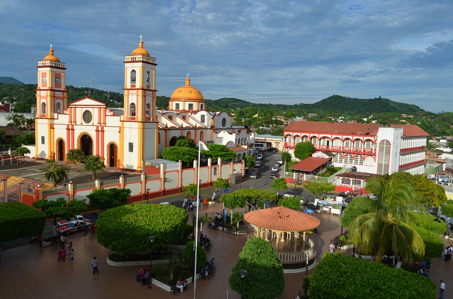


San Andrés Tuxtla, Mexico
San Andrés Tuxtla is a town of 61,769 people in Veracruz, Mexico, founded in 1530.
Why visit San Andrés Tuxtla
Townapedia lists 6 museums and landmarks, 8 parks and trails, 11 places to eat, 13 places to stay and 1 attraction in and around town.
Weather in San Andrés Tuxtla
Forecast from MET Norway (CC BY 4.0). Full forecast
About San Andrés Tuxtla
San Andrés Tuxtla is a city and municipality in the south of the Mexican state of Veracruz. The city is the largest in the Los Tuxtlas region. It was founded after an eruption of the San Martín Volcano pushed people into this valley during the early colonial period. Since the 19th century, the area has been the center of Mexico's production of fine tobacco, mostly used in the making of cigars.
From the Wikipedia article San Andrés Tuxtla (this version), under CC BY-SA 4.0.
Travel tips from other travellers: San Andrés Tuxtla on Wikivoyage (CC BY-SA 4.0).
Things to do1

Museums and landmarks6


Parks, trails and playgrounds8

Restaurants and cafes11


Panificadora San Andrés
Bakery
Panificadora en el centro, pan tradicional de San Andrés.



History
The name "Tuxtla" is derived from Nahuatl and means "place of the rabbit". San Andrés refers to the patron saint, Saint Andrew.
In the 16th century, the area belonged to the Santiago Tuxtla province. In 1530 there was an eruption of the San Martín Volcano, which prompted the movement of people from Ixtlán to what is now the city of San Andrés Tuxtla, then called Tuzacoalco (land between the mountains). The settlement was recognized in 1580 by the head of the Tlacotalpan, Tuztla and Cotaxtla region.
Its tobacco history began in 1830 when a slow influx of Cubans and Europeans made their way here and decided that the climate was apt for the growing of fine tobacco. Today, the area produces some of the finest cigars in the world. Just prior to the Mexican Revolution the industry experienced strikes by workers, with the first occurring at the El Destino factory in 1896.
The municipality was defined in 1825 and in 1826 the city was declared its seat. In 1830 the seat was declared a town, and in 1893 a city.
In 1932, the city and municipality's name was changed to Los Tuxtlas, but this was changed back to San Andrés Tuxtla in 1938.
From the History section of San Andrés Tuxtla on Wikipedia, under CC BY-SA 4.0.
Where to stay13
Churches and places of worship15
Shopping11
Gas and EV charging6
Schools, colleges and libraries25
Healthcare11
Map of San Andrés Tuxtla
107 places. The map loads OpenStreetMap tiles when you open it.
Getting there and nearby towns
Minatitlán National Airport (MTT) is the nearest airport with scheduled flights listed in OpenStreetMap, 77 km away.
- Tonalapan 2 km north, about 2 min by car
- Los Pinos 3 km west, about 3 min by car
- San Isidro Xoteapan (San Isidro Texcaltitán) 3 km northwest, about 3 min by car
- Sihuapan 4 km east, about 4 min by car
- Texalpan de Arriba 4 km southwest, about 4 min by car
- Buenos Aires 4 km northwest, about 4 min by car
- Calería 4 km southeast, about 4 min by car
- Texcaltitán Xoteapan (Texcaltitán) 4 km west, about 4 min by car
- Minatitlán 85 km southeast, about 1 h 30 min by car
- Coatzacoalcos 88 km east, about 1 h 30 min by car
Drive times are estimates from straight-line distance, not routes.
Local news
Headlines from INDB.
Reviews, tips and questions
Loading what members have shared...
Sources and licences
- GeoNames (CC BY 4.0): population, coordinates, regions and time zone
- OpenStreetMap contributors (ODbL 1.0): places, airports, map data
- Wikidata (CC0 1.0): elevation, founding date, time zone, website, landmarks and historic places
- Wikimedia Commons (see each image): photos
- Wikipedia (CC BY-SA 4.0): overview and history text
Photo credits
- San-Andrés-Tuxtla Veracruz-0001IR, Angel xala13, CC BY-SA 4.0
- Cabeza olmeca, museo de San Andrés Tuxtla, Gunnar Wolf, CC BY-SA 3.0
- Museo de San Andrés Tuxtla, Gunnar Wolf, CC BY-SA 3.0
- Plaza de San Andrés Tuxtla, Gunnar Wolf, CC BY-SA 3.0
- CathedralSanAndresTuxtla02, AlejandroLinaresGarcia, CC BY-SA 3.0
- BenitoJuarezSanAndresTuxtla, AlejandroLinaresGarcia, CC BY-SA 3.0
- Main Plaza San Andres Tuxtla, AlejandroLinaresGarcia, CC BY-SA 3.0
- CathedralSanAndresTuxtla19, AlejandroLinaresGarcia, CC BY-SA 3.0
- CathedralSanAndresTuxtla18, AlejandroLinaresGarcia, CC BY-SA 3.0
- CathedralSanAndresTuxtla01, AlejandroLinaresGarcia, CC BY-SA 3.0
- CathedralSanAndresTuxtla03, AlejandroLinaresGarcia, CC BY-SA 3.0
- SantaRosaSanAndres01, AlejandroLinaresGarcia, CC BY-SA 3.0
- SantaRosaSanAndres02, AlejandroLinaresGarcia, CC BY-SA 3.0
- Bigboxpizza, Jeffrey Balandran Beaven, CC BY 3.0


Page built November 4, 2026. Spotted a mistake? Tell us or suggest a place.