
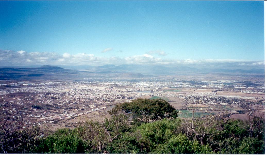


San Juan del Río, Mexico
San Juan del Río is a town of 138,878 people in Querétaro, Mexico, founded in 1531.
Why visit San Juan del Río
Townapedia lists 24 museums and landmarks, 75 parks and trails, 47 places to eat, 8 places to stay and 8 attractions in and around town.
Highlights include Panteón/Museo de la Santa Veracruz, Puente de la Historia, Area verde and anonimo.
Weather in San Juan del Río
Forecast from MET Norway (CC BY 4.0). Full forecast
About San Juan del Río
San Juan del Río is a city (2010 census pop. 241,699) and administrative center of the surrounding San Juan del Río Municipality (pop. 308,462) in the central Mexican state of Querétaro. The population within the municipality is 268,408 as of 2015.
From the Wikipedia article San Juan del Río (this version), under CC BY-SA 4.0.
Travel tips from other travellers: San Juan del Río on Wikivoyage (CC BY-SA 4.0).
Things to do8



Museums and landmarks24

Panteón/Museo de la Santa Veracruz
Museum · 0.6 km
10 2 de Abril
We-Mo 09:00-18:00



Ex - Hacienda La Llave
Monument and historic site · 8.6 km
Calle Hacienda La Llave, La Llave
Antigüo pozo de Nuestra Señora de Guadalupe
Monument and historic site · 0.6 km
Calle Ignacio Allende
Parque líneal "Riviera del Río San Juan"
Monument and historic site · 0.7 km
Calle Paseo del Rio
12 more on the map.
Parks, trails and playgrounds75

Campo Deportivo La Guitarrilla
Park · 2.0 km
Entrena aquí un equipo local de Flag Football, hay una pequeña área de juegos infantiles
63 more on the map.
Restaurants and cafes47

Boliche Super Bowl VII
Diner · American · 1.1 km
Avenida Miguel Hidalgo y Costilla
We-Th 16:30-23:30; Fr 06:00-23:30; Sa-Su 14:30-23:30

Tangolunda
Restaurant · Regional, Mexican · 3.1 km
Calle Jacarandas, san juan del rio
Mo-Su 08:00-21:00

Tim Hortons
Cafe · Coffee Shop · 1.2 km
Avenida Central, San Juan del Río
desconocido
Toks
Restaurant · Mexican · 1.3 km
183,Colonia Zona industrial Valle de Querétaro Plaza Paseo San Juan ,Paseo Central, San Juan del Río , Querétaro
Venta de antojitos
Restaurant · Regional · 5.2 km
Avenida las Águilas, San Juan del Río
35 more on the map.
History
The city was founded on the Feast of Saint John the Baptist June 24, 1531, by Fernando de Tapia, an Otomí chieftain that converted to Catholicism and dropped his Native name Conín. San Juan was one of the first Spanish settlements outside the Valley of Mexico and thus marked the beginning of the colonization of Northern and Western Mexico, including the city of Querétaro, which was founded one month later. The settlement became important since it was an obligated stop during the rich mining regions of Guanajuato, Zacatecas and San Luis Potosí.
From the History section of San Juan del Río on Wikipedia, under CC BY-SA 4.0.
Where to stay8
Hotel Hacienda La Venta
Motel and hotel · 1.8 km
Avenida Ingeniero Luis Romero Soto, San Juan del Río
Churches and places of worship22
Antigua Capilla de Santa Cruz Nieto
Church · Catholic · 3.3 km
Calle Central, san juan del rio
Igleasia de Santa Cruz Nieto
Church · Catholic · 3.2 km
Calle Benito Juarez, san juan del rio
Iglesia de San Isidro Labrador
Church · Catholic · 2.2 km
9 Calle 15 de Mayo, San Juan del Río
Nueva Iglesia de Santa Cruz Nieto
Church · Catholic · 3.2 km
Calle Benito Juarez, san juan del rio
Templo de El Beaterio de Hermanas Terceras de San Francisco
Place of worship · 0.7 km
Benito Juarez
Shopping34
Galerías San Juan del Río
Shopping center · 1.7 km
202 Carretera Panamericana a Querétaro, San Juan del Río
Plaza Santa Cruz Nieto
Shopping center · 2.8 km
Calle Santa Cruz, san juan del rio
Centro comercial "Galerías San Juan del Río"
Shopping center · 1.8 km
Panamericana a Querétaro
Gas and EV charging21
Gasolineria "La Curva"
Gas station
Avenida Benito Juaréz Oriente, San Juan del Río
Schools, colleges and libraries44
Escuela Primaria Miguel Hidalgo
School · None · 3.2 km
Calle Palmas, san juan del rio
Jardin de Niños David Alfaro Siqueiros
School · None · 3.0 km
Laureles, san juan del rio
Centro de Capacitación para el Trabajo Industrial Número 22
School · 1.9 km
130 Avenida Universidad
Escuela Telesecundria Rafael Ayala Echeverrí
School · None · 3.0 km
Laureles, san juan del rio
Primaria Dr. Rafael Ayala Echavarrí
School · 1.0 km
105 Calle José María Pino Suarez
Healthcare27
Centro Médico "Coscami"
Clinic and pharmacy · 2.2 km
160 Avenida Río Moctezuma, San Juan del Río
Farmacia Guadalajara
Clinic and pharmacy · 2.8 km
Avenida Río Moctezuma, San Juan del Río
Farmacias del Ahorro
Clinic and pharmacy · 1.4 km
Avenida Miguel Hidalgo y Costilla
Map of San Juan del Río
250 places. The map loads OpenStreetMap tiles when you open it.
Getting there and nearby towns
Querétaro International Airport (QRO) is the nearest airport with scheduled flights listed in OpenStreetMap, 33 km away.
- Casa Blanca 2 km west, about 2 min by car
- Vista Hermosa (Cuasinada) 3 km southwest, about 3 min by car
- Loma Linda 4 km west, about 4 min by car
- Lázaro Cárdenas (1ra. Sección del Rodeo) 4 km southeast, about 4 min by car
- El Rodeo 5 km southeast, about 5 min by car
- Santa Cruz Escandón 5 km northeast, about 5 min by car
- San Francisco 6 km southeast, about 6 min by car
- Santa Matilde 6 km northwest, about 6 min by car
- Santiago de Querétaro 46 km northwest, about 46 min by car
- Celaya 86 km west, about 1 h 30 min by car
Drive times are estimates from straight-line distance, not routes.
Local news
Headlines from INDB.
Reviews, tips and questions
Loading what members have shared...
Sources and licences
- GeoNames (CC BY 4.0): population, coordinates, regions and time zone
- OpenStreetMap contributors (ODbL 1.0): places, airports, map data
- Wikidata (CC0 1.0): elevation, founding date, time zone, website
- Wikimedia Commons (see each image): photos
- Wikipedia (CC BY-SA 4.0): overview and history text
Photo credits
- Vista de SJR, Gabriel monarca, Public domain
- La paloma, San Juan del Río - panoramio, verdo_iglesias, CC BY-SA 3.0
- Hacienda La Llave, San Juan del Río, A01704702 Sofia Roman, CC BY-SA 4.0
- Puente de Piedra de San Juan del Río, Neftsaenz, CC BY-SA 4.0
- Puente de la Historia San Juan del RIO, Abdeel Yañez Quintanar, CC BY-SA 3.0
- ISS065-E-213290 - View of Earth, Earth Science and Remote Sensing Unit , Lyndon B. Johnson Space Center, Public domain
- ISS028-E-41421 - View of Earth, Earth Science and Remote Sensing Unit , Lyndon B. Johnson Space Center, Public domain
- ISS065-E-31444 - View of Earth, Earth Science and Remote Sensing Unit , Lyndon B. Johnson Space Center, Public domain
- ISS065-E-213291 - View of Earth, Earth Science and Remote Sensing Unit , Lyndon B. Johnson Space Center, Public domain
- ISS035-E-21449 - View of Earth, Earth Science and Remote Sensing Unit , Lyndon B. Johnson Space Center, Public domain
- ISS065-E-213293 - View of Earth, Earth Science and Remote Sensing Unit , Lyndon B. Johnson Space Center, Public domain
- ISS065-E-213292 - View of Earth, Earth Science and Remote Sensing Unit , Lyndon B. Johnson Space Center, Public domain
- McDonalds - panoramio (3), JAGarcia, CC BY 3.0
- Pyrocephalus obscurus, Querétaro, Mexico 06 11 2024, TheMushe, CC0
- Parroquia de San Pedro Ahuacatlán, Richard Xingú Ramírez, CC BY-SA 3.0
- La llave hacienda, A01701113 Ale, CC BY-SA 4.0
- Camp militar, A01701113 Ale, CC BY-SA 4.0
- Jardín Botánico, Hacienda de la Llave, Diego Zamorano Pulido, CC BY-SA 4.0
- Explanada de la Hacienda La Llave, A01703196 Max, CC BY-SA 4.0
- Interior de hacienda La Llave, A01209925Christian, CC BY-SA 4.0
- OficinadeExHaciendaLaLlave, Jose Eduardo Garcia Avila, CC BY-SA 4.0
- Vitral, Bandera de México, A01702977 KIARETSALVADOR, CC0
- Entrada Hacienda La Llave, Christian Ricardo Cáceres Cáceres, CC BY-SA 4.0
- ExHaciendaLaLlave, A01700962.Daniela, CC BY-SA 4.0
- Tanque blindado, Cela Ayline Jiménez Hernández, CC BY-SA 4.0
- Hacienda la llave, Alexialef, CC BY-SA 3.0
- TanqueExHaciendaLaLlave, A01700962.Daniela, CC BY-SA 4.0
- Camión Militar Blindado, A01702977 KIARETSALVADOR, CC BY-SA 4.0
- La patria es primero, A01704627.ggg, CC BY-SA 4.0
- Bandera Hacienda La Llave, Alfredo Wolstano Cano Tellez, CC BY-SA 4.0
- ISS029-E-17486 - View of Earth, Earth Science and Remote Sensing Unit , Lyndon B. Johnson Space Center, Public domain
- Lentes rojos, A01704227, CC BY-SA 4.0


Page built November 4, 2026. Spotted a mistake? Tell us or suggest a place.