
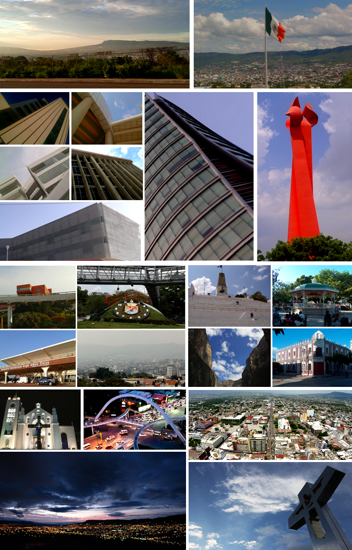


Tuxtla, Mexico
Tuxtla Gutiérrez
Tuxtla is a regional capital of 604,147 people in Chiapas, Mexico.
Why visit Tuxtla
Townapedia lists 19 museums and landmarks, 30 parks and trails, 53 places to eat, 67 places to stay and 2 attractions in and around town.
Highlights include University of Sciences and Arts of Chiapas, Cristo de Chiapas, Regional Museum of Anthropology and History of Chiapas and Zoológico Miguél Álvarez del Toro.
Weather in Tuxtla
Forecast from MET Norway (CC BY 4.0). Full forecast
About Tuxtla
Tuxtla Gutiérrez, or Tuxtla, (Spanish: [ˈtuɣstla ɣuˈtjeres] , Nahuatl: [ˈtuʃt͡ɬa]) is the capital and largest city of the southeast Mexican state of Chiapas. It is the seat of the municipality of the same name, which is the most developed and populous in Chiapas. A busy city government, commercial and services-oriented city, Tuxtla had one of the fastest-growing rates in Mexico between 1974 and 2014. Unlike many other cities in Chiapas, it is not a major tourist attraction, but a transportation hub for tourists coming into the state, with a large airport and a bus terminal.
From the Wikipedia article Tuxtla Gutiérrez (this version), under CC BY-SA 4.0.
Travel tips from other travellers: Tuxtla on Wikivoyage (CC BY-SA 4.0).
Things to do2

University of Sciences and Arts of Chiapas
School · 2.6 km
Multi-campus university in Tuxtla, Chiapas, Mexico.

Museums and landmarks19

Cristo de Chiapas
Monument and historic site · 4.0 km
Monumental cross in Tuxtla Gutiérrez, Chiapas, Mexico

Regional Museum of Anthropology and History of Chiapas
Museum · 1.2 km
Museum in Tuxtla Gutiérrez, Mexico



7 more on the map.
Parks, trails and playgrounds30





Estadio de Futbol Americano Samuel León Brindis
Sports field and stadium · 1.7 km
18 more on the map.
Restaurants and cafes53

Coffee "DeChiapas"
Restaurant · American, Coffee Shop, Mexican · 1.5 km
171 Boulevard Doctor Belisario Domínguez
Mo-Sa 08:00-00:00; Su 08:00-23:00

La Piñata Pastelería y Cafetería
Cafe · Coffee Shop, Dessert, Pastry, Tea · 1.4 km
1055 local 12 Avenida Décima Norte Poniente, Tuxtla Gutiérrez
Mo-Su 14:00-21:00
Hierba Santa
Restaurant · Mexican · 0.6 km
Mo 09:00-15:00; Tu-Sa 09:00-20:30; Su 10:00-15:30
Pura Vida
Restaurant
232 Calle 4a. Oriente Norte
Mo-Fr 12:00-16:30
41 more on the map.
History
The Zoques made the first pre-Hispanic settlement at the site. They named the valley area name Coyatoc, which means 'land or house of rabbits'. The Aztecs intruded into the area between 1486 and 1505 and named it Tuchtlan, which means the same thing in their language.
After the Spanish conquest of the Aztec Empire, and the subjugation of the local Chiapan people in 1528, the Dominicans constructed a monastery in nearby Tecpatán. There is no official founding date for Tuxtla, but it is known that the Dominican monks gathered dispersed Zoques into communities organized around churches in the 16th century. A church dedicated to San Marcos (Saint Mark) was founded by the Dominicans for one of these communities in 1560. While Tuxtla is less discussed in regional history as compared to Comitán Domínguez and San Cristóbal, it boasts a large number of adobe houses, including Spanish colonial buildings in the downtown and western areas around the Señor del Cerrito Hermitage, from the 19th century within the downtown area and far southern and northern areas, and vestiges of Zoquean migration during the 19th century in the western and far southwestern areas. Tuxtla is home to around 800 adobe houses, many times much more than any officially declared historic site in Chiapas.
From the History section of Tuxtla Gutiérrez on Wikipedia, under CC BY-SA 4.0.
Where to stay67
Hostel Calle 8
Motel and hotel · 0.8 km
8a Poniente Norte #126 Colonia Centro, 29000 Tuxtla Gutiérrez, Mexico
Jesus esperanza en el camino
Motel and hotel · 1.9 km
664 1a Poniente, Tuxtla, Gutierrez
Una ayuda para ti mujer migrante
Motel and hotel · 1.4 km
1425A 5a Poniente Sur, Tuxtla, Gutierrez
Churches and places of worship7
La Iglesia de Nuestra Señora Guadalupe
Church · Roman Catholic · 0.6 km
752 Avenida Central Poniente, Tuxtla Gutiérrez
Shopping17
Plaza Marfil Vista Hermosa
Shopping center · 1.4 km
1055 Avenida Décima Norte Poniente, Tuxtla Gutiérrez
Suc. Periferico Climas Comerciales
Grocery · 2.2 km
2020 Perif. Sur Pte., Tuxtla gutierrez
Gas and EV charging7
Schools, colleges and libraries21
Escuela Normal de Licenciatura en Educación Preescolar "Bertha Von Glumer y Leyva"
School · 2.0 km
Escuela Normal de Licenciatura en Educación Preescolar "Rosaura Zapata Cano"
School · 2.0 km
Healthcare32
Map of Tuxtla
250 places. The map loads OpenStreetMap tiles when you open it.
Getting there and nearby towns
Aeropuerto Internacional Ángel Albino Corzo (TGZ) is the nearest airport with scheduled flights listed in OpenStreetMap, 24 km away.
- Copoya 5 km south, about 5 min by car
- El Jobo 6 km south, about 6 min by car
- Jardínes del Grijalva 9 km east, about 9 min by car
- Las Flechas 11 km southeast, about 11 min by car
- La Libertad 11 km west, about 11 min by car
- Chiapa de Corzo 12 km southeast, about 12 min by car
- Viva Cárdenas 12 km northwest, about 12 min by car
- Pacú 13 km south, about 13 min by car
- Triunfo Agrarista 12 km northeast, about 12 min by car
- Suchiapa 14 km south, about 14 min by car
Drive times are estimates from straight-line distance, not routes.
Local news
Headlines from INDB.
Reviews, tips and questions
Loading what members have shared...
Sources and licences
- GeoNames (CC BY 4.0): population, coordinates, regions and time zone
- OpenStreetMap contributors (ODbL 1.0): places, airports, map data
- Wikidata (CC0 1.0): elevation, founding date, time zone, website, landmarks and historic places
- Wikimedia Commons (see each image): photos
- Wikipedia (CC BY-SA 4.0): overview and history text
Photo credits
- Tuxtla Gutiérrez - Mosaico Fotográfico, Pxndx94, Public domain
- Catedral de Tuxtla Gutierrez - panoramio, Carlos Perez Chavez, CC BY-SA 3.0
- SanMarcosTuxtla03, AlejandroLinaresGarcia, CC BY-SA 4.0
- SanMarcosTuxtla04, AlejandroLinaresGarcia, CC BY-SA 4.0
- CentralPteTuxtlaGtz, AlejandroLinaresGarcia, CC BY-SA 4.0
- SanMarcosTuxtla02, AlejandroLinaresGarcia, CC BY-SA 4.0
- Panorámica de Tuxtla Gutiérrez desde el aire (recortado), BZUR, CC BY-SA 4.0
- Panorámica de Tuxtla Gutiérrez desde el aire, BZUR, CC BY-SA 4.0
- FacadeSanMarcosTuxtla02, AlejandroLinaresGarcia, CC BY-SA 4.0
- FacadeSanMarcosTuxtla, AlejandroLinaresGarcia, CC BY-SA 4.0
- Parque Central de Tuxtla. - panoramio, Nacasma, CC BY 3.0
- SanMarcosTuxtla, AlejandroLinaresGarcia, CC BY-SA 4.0
- Mapping en la Catedral Metropolitana de Tuxtla Gutiérrez, BZUR, CC BY-SA 4.0
- Saint Paul VI Pope (Catedral de San Marcos, Tuxtla Gutiérrez), Catedrales e Iglesias/Cathedrals and Churches, CC BY 2.0
- MunicipalPalaceTuxtlaG, AlejandroLinaresGarcia, CC BY-SA 4.0
- Puerta de Acceso a la Sala Principal del Teatro Francisco I. Madero de Tuxtla Gutiérrez, BZUR, CC BY-SA 4.0
- Cristo de Copoya - panoramio (1), ricraider, CC BY-SA 3.0
- HallRegMusTuxtla, AlejandroLinaresGarcia, CC BY-SA 4.0
- Tuxtla06, Unknown author, Public domain
- Tuxtla Gutiérrez México Temple, ARTEST4ECHO, Public domain
- Estadio Zoque Víctor Manuel Reyna, Carlos Urbina, CC BY-SA 4.0
- Cristo de Copoya - panoramio, Nacasma, CC BY 3.0
- AtriumCongresoTuxla, AlejandroLinaresGarcia, CC BY-SA 4.0
- Alexander Cal y Mayor Vázquez, Ei360, CC BY-SA 4.0
- TAMAÑO RELATIVO 2, Fujiiy, CC BY-SA 4.0
- POLLO CAMPERO CENTRO - panoramio, baldov, CC BY-SA 3.0
- Catedral y el Congreso del estado - panoramio, Nacasma, CC BY 3.0
- Estatua de Benito Juarez. Congreso del Estado. - panoramio, Nacasma, CC BY 3.0
- Estatua de Benito Juarez. Congreso del Estado de Chiapas. - panoramio, Nacasma, CC BY 3.0
- Restaurante La Torta Vaquera - panoramio, h0lm, CC BY-SA 3.0
- Catedral de San Marcos (2), Dge, CC BY-SA 4.0
- CatedralSanMarcos1, Paco Baeza, CC BY-SA 3.0
- Catedral de San Marcos (4), Dge, CC BY-SA 4.0
- Catedral de San Marcos (12), Dge, CC BY-SA 4.0
- Cupula del Congreso del Estado de Chiapas. - panoramio, Nacasma, CC BY 3.0
- Cruz de Copoya. - panoramio, Nacasma, CC BY 3.0
- Cristo copoya, Nacasma, Public domain
- Cruz en el Cerro de Copoya. - panoramio, Nacasma, CC BY 3.0
- Museo de la Ciudad. - panoramio, Nacasma, CC BY 3.0
- Cougar (32868243878), PY Constantino Diaz, CC BY 2.0
- Museo Botanico. Dr. Faustino Miranda. - panoramio, Nacasma, CC BY 3.0
- Museo de Antropologia e Historia. - panoramio, Nacasma, CC BY 3.0


Page built November 4, 2026. Spotted a mistake? Tell us or suggest a place.