


New Hartford, New York
New Hartford is a village of 1,989 people in Oneida County, New York.
Why visit New Hartford
Townapedia lists 11 museums and landmarks, 6 parks and trails, 26 places to eat and 1 place to stay in and around town.
Highlights include Fort Schuyler Club Building, Fountain Elms and Utica Zoo.
July is the warmest month, with average highs of 80°F; January lows average 14°F.
Weather in New Hartford
Forecast from the National Weather Service. Full forecast
About New Hartford
For other places with this name, see New Hartford (disambiguation).
From the Wikipedia article New Hartford (village), New York (this version), under CC BY-SA 4.0.
Museums and landmarks11

Fort Schuyler Club Building
Monument and historic site · National Register of Historic Places · 3.3 mi
Clubhouse in New York, United States of America

Fountain Elms
Monument and historic site · National Register of Historic Places · 3.0 mi
Historic house in New York, United States

Middle Mill Historic District
Monument and historic site · National Register of Historic Places · 2.4 mi
Historic district in New York, United States

Millar-Wheeler House
Monument and historic site · National Register of Historic Places · 2.8 mi
Historic house in New York, United States

Munson-Williams-Proctor Arts Institute
Museum · National Register of Historic Places · 3.0 mi
Arts center in Utica, New York

New Century Club
Monument and historic site · National Register of Historic Places · 3.3 mi
Clubhouse in Utica, New York
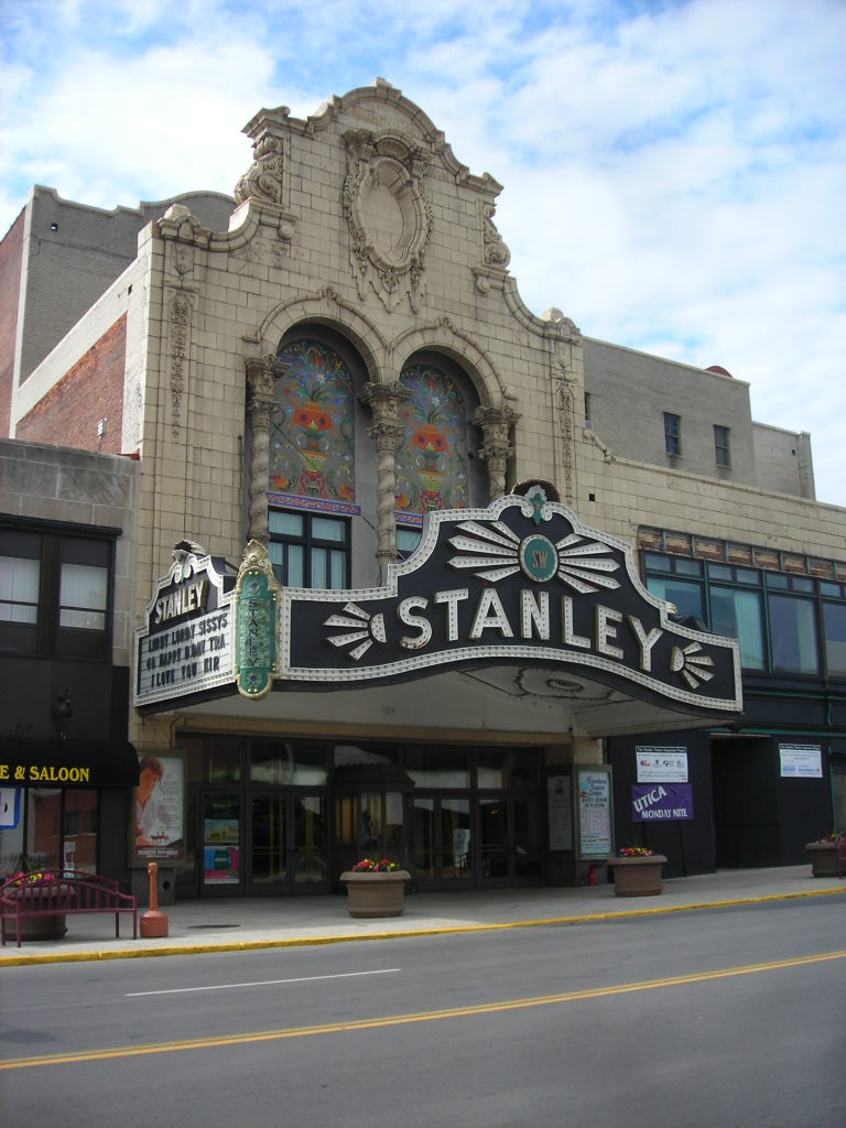
Stanley Theater
Cinema and theater · National Register of Historic Places · 3.3 mi
Theater in Utica, New York, United States

Utica Parks and Parkway Historic District
Monument and historic site · National Register of Historic Places · 2.9 mi
Historic district in Utica, New York

Utica Psychiatric Center
Monument and historic site · National Register of Historic Places · 2.9 mi
Historic building in New York state, USA


Utica Public Library
Monument and historic site · National Register of Historic Places · 3.1 mi
Historic library building located in Utica, New York, United States

Sculpture Space
Museum · 3.3 mi
Sculpture studio in upstate New York, USA
Parks, trails and playgrounds6



Restaurants and cafes26

Calabria Coffee
Cafe · Coffee Shop
52 Genesee Street, New Hartford
Mo-Fr 07:00-18:00; Sa 08:00-18:00; Su 08:00-17:00

Apsa
Restaurant · Asian, Cambodian, Thai, Vietnamese · 0.5 mi
103 New Hartford Shopping Center, New Hartford
China House
Restaurant · Chinese · 1.5 mi
3913 Oneida Street, New Hartford
Su-Th 10:30-21:45, Fr-Sa 10:30-22:45
Rio Grande Tex Mex Grill
Restaurant · Mexican, Tex-Mex · 1.5 mi
3913 Oneida Street, New Hartford
Mo-Sa 11:00-21:00
Tony's Pizzeria
Restaurant · Italian, Pizza · 1.5 mi
3899 Oneida Street, New Hartford
Mo-Fr 10:00-23:00, Sa-Su 10:00-00:00

Utica Bread
Bakery
54;52 Genesee Street, New Hartford
We-Su 08:00-14:00
14 more on the map.
Where to stay1

History
The village was founded in 1789 by the construction of a log cabin by the Sanger family, who later constructed mills nearby. The village was a commercial success, until the opening of the Erie Canal gave Utica a big advantage.
The village Fire Department was started in 1901. The NHFD provides fire protection and advanced life support emergency medical service to the village and portions of the town of New Hartford. These communities are served by an active corps of 98 volunteer firefighters. Based on dispatch records, it is the busiest volunteer fire department in Oneida County.
There are a few houses along Oxford Road that were used to hide slaves on the Underground Railroad.
St. Stephen's Church was listed on the National Register of Historic Places in 1996.
From the History section of New Hartford (village), New York on Wikipedia, under CC BY-SA 4.0.
Churches and places of worship19
Calvary Episcopal Church
Church · National Register of Historic Places · 3.4 mi
First Presbyterian Church
Church · National Register of Historic Places · 2.4 mi
St. Joseph's Church
Church · National Register of Historic Places · 3.3 mi
Tabernacle Baptist Church
Church · National Register of Historic Places · 3.3 mi
Shopping4
Gas and EV charging2
Schools, colleges and libraries40
Healthcare2
Map of New Hartford
111 places. The map loads OpenStreetMap tiles when you open it.
Climate by month
Monthly table
| Month | High | Low | Rain |
|---|---|---|---|
| Jan | 30°F | 14°F | 2.6 in |
| Feb | 32°F | 15°F | 2.3 in |
| Mar | 40°F | 23°F | 3.0 in |
| Apr | 55°F | 34°F | 3.9 in |
| May | 68°F | 46°F | 3.9 in |
| Jun | 76°F | 55°F | 4.5 in |
| Jul | 80°F | 60°F | 4.2 in |
| Aug | 79°F | 58°F | 4.7 in |
| Sep | 72°F | 51°F | 3.5 in |
| Oct | 59°F | 41°F | 4.3 in |
| Nov | 46°F | 31°F | 3.6 in |
| Dec | 35°F | 21°F | 3.6 in |
U.S. Climate Normals 1991-2020 for Utica Oneida Co Ap Hcn (7 mi away), NOAA NCEI.
People and cost of living
American Community Survey 5-year estimates, 2020-2024, U.S. Census Bureau. Estimates have margins of error, larger for small towns.
Disaster history
Oneida County has had 23 federal disaster declarations since 2000, most often for severe storms.
- 2022-11-20: Severe Winter Storm And Snowstorm (Winter Storm)
- 2021-10-08: Remnants Of Tropical Storm Fred (Hurricane)
- 2020-03-20: Covid-19 Pandemic (Biological)
- 2020-03-13: Covid-19 (Biological)
- 2019-12-19: Severe Storms, Straight-Line Winds, And Flooding (Severe Storm)
- 2017-07-12: Severe Winter Storm And Snowstorm (Snowstorm)
OpenFEMA disaster declarations summaries.
Getting there and nearby towns
Griffiss International Airport (RME) is the nearest airport with scheduled flights listed in OpenStreetMap, 12 miles away.
- Utica 4 mi northeast, about 6 min by car
- Clark Mills 5 mi west, about 7 min by car
- Clinton 5 mi west, about 8 min by car
- Rome 15 mi northwest, about 24 min by car
- Oneida 19 mi west, about 31 min by car
- Morrisville 22 mi southwest, about 35 min by car
- Dolgeville 26 mi east, about 41 min by car
- Boonville 28 mi north, about 46 min by car
- DeWitt 40 mi west, about 1 h by car
- Syracuse 43 mi west, about 1 h 15 min by car
Drive times are estimates from straight-line distance, not routes.
Local news
Headlines from INDB, the NEMICO news database.
Reviews, tips and questions
Loading what members have shared...
Sources and licences
- NCES EDGE (Public domain): public schools
- NOAA NCEI U.S. Climate Normals 1991-2020 (Public domain): climate by month
- OpenFEMA (Public domain): disaster declarations
- OpenStreetMap contributors (ODbL 1.0): places, airports, map data
- U.S. Census Bureau (Public domain): population, income, housing, education, commute
- Wikidata (CC0 1.0): elevation, founding date, time zone, website, landmarks and historic places
- Wikimedia Commons (see each image): photos
- Wikipedia (CC BY-SA 4.0): overview and history text
Photo credits
- St. Stephen's Church, New Hartford, Agreen54, CC BY-SA 4.0
- St. Stephen's Church, New Hartford, New York 02, Doug Kerr, CC BY-SA 2.0
- First Baptist Church, New Hartford, New York, Doug Kerr, CC BY-SA 2.0
- St. Stephen's Church, New Hartford, New York 01, Doug Kerr, CC BY-SA 2.0
- St. Stephen's Church, New Hartford, New York 04, Doug Kerr, CC BY-SA 2.0
- St. Stephen's Church, New Hartford, New York 03, Doug Kerr, CC BY-SA 2.0
- New Hartford Presbyterian Church 03, Doug Kerr, CC BY-SA 2.0
- New Hartford Presbyterian Church 01, Doug Kerr, CC BY-SA 2.0
- New Hartford Presbyterian Church 02, Doug Kerr, CC BY-SA 2.0
- St. John the Evangelist Church, New Hartford, New York, front (2014), Michael Scialdone, CC BY 2.0
- NY 12 nb at Genesee Street, New Hartford, July 2023, Mr. Matté (if there is an issue with this image, contact me using this image's Commons talk page , my Commons user talk page , or my English Wikipedia user talk page ; I'll know about it a lot faster), CC BY-SA 4.0
- St Joseph's Church Utica, Agreen54, CC BY-SA 4.0
- Fountain Elms in Utica New York taken 09302012, KrisBellino, CC BY-SA 3.0
- UticaStateHospital center December2007, Doncram, CC BY-SA 4.0
- FortSchuylerClubBuilding, Lvklock, CC BY-SA 4.0
- Munson-Williams-Proctor Arts Institute, Utica NY, Kenneth C. Zirkel, CC BY-SA 4.0
- Calvary Episcopal Church, Utica, New York, Kenneth C. Zirkel, CC BY-SA 4.0
- Bathhouse Arch, Roger B. Smith, CC0
- Utica Public Library, Doug Kerr from Upstate New York, CC BY-SA 2.0
- Stanley Theater Utica NY Jun 07, Doug Kerr from Albany, New York, United States, CC BY-SA 2.0
- FirstPresbyterianChurchUtica, Lvklock, CC BY-SA 4.0
- Tabernacle Baptist Church Utica, New York Jun 07, Doug Kerr, CC BY-SA 2.0
- MillarWheelerHouse, Lvklock, CC BY-SA 4.0
- NewCenturyClub, Lvklock, CC BY-SA 4.0
- Wankel Park French Road 7 - panoramio, James Stockton, CC BY 3.0
- Wankel Park French Road 8 - panoramio, James Stockton, CC BY 3.0
- Wankel Park French Road 5 - panoramio, James Stockton, CC BY 3.0
- Wankel Park French Road 1 - panoramio, James Stockton, CC BY 3.0
- Wankel Park French Road 4 - panoramio, James Stockton, CC BY 3.0
- Wankel Park French Road 6 - panoramio, James Stockton, CC BY 3.0
- Wankel Park French Road 9 - panoramio, James Stockton, CC BY 3.0
- Wankel Park French Road 2 - panoramio, James Stockton, CC BY 3.0
- Wankel Park French Road 3 - panoramio, James Stockton, CC BY 3.0
- NY 840, Otto Yamamoto, CC BY-SA 2.0


Page built October 30, 2026. Spotted a mistake? Tell us or suggest a place.