


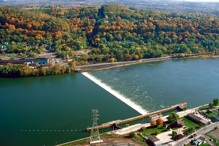


New Kensington, Pennsylvania
New Kensington is a city of 12,011 people in Westmoreland County, Pennsylvania, founded in 1891.
Why visit New Kensington
Townapedia lists 16 museums and landmarks, 16 parks and trails, 23 places to eat, 1 place to stay and 2 attractions in and around town.
Highlights include C. L. Schmitt Bridge, George D. Stuart Bridge, Allegheny River Lock and Dam No. 4 and Byerly House.
July is the warmest month, with average highs of 83°F; January lows average 20°F.
Weather in New Kensington
Forecast from the National Weather Service. Full forecast
About New Kensington
New Kensington (known locally as New Ken) is a city in Westmoreland County, Pennsylvania, United States. The population was 12,170 at the 2020 census. It is situated along the Allegheny River 18 miles (29 km) northeast of Pittsburgh and is part of the Pittsburgh metropolitan area.
From the Wikipedia article New Kensington, Pennsylvania (this version), under CC BY-SA 4.0.
Things to do2

C. L. Schmitt Bridge
Bridge · 1.2 mi
Bridge in Pennsylvania, United States

George D. Stuart Bridge
Bridge · 1.7 mi
Bridge over the Allegheny River in Pennsylvania
Museums and landmarks16
Allegheny River Lock and Dam No. 4
Monument and historic site · National Register of Historic Places · 3.5 mi
Gravity dam and lock in Harrison Township, Pennsylvania

Byerly House
Monument and historic site · National Register of Historic Places · 3.9 mi
Historic house in Pennsylvania, United States

Logans Ferry Powder Works Historic District
Monument and historic site · National Register of Historic Places · 2.5 mi
Historic district in Pennsylvania, United States


New Kensington Downtown Historic District
Monument and historic site · National Register of Historic Places · 0.8 mi
Historic district in New Kensington, Pennsylvania
New Kensington Production Works Historic District
Monument and historic site · National Register of Historic Places · 1.0 mi
Historic district in Pennsylvania, United States
Pennsalt Historic District
Monument and historic site · National Register of Historic Places · 3.4 mi
Historic district in Pennsylvania, United States
Rachel Carson Homestead
Monument and historic site · National Register of Historic Places · 2.4 mi
Birthplace of Rachel Carson

4 more on the map.
Parks, trails and playgrounds16

Fireman's Memorial Park
Park · 1.0 mi
Has a few gazebos as well as signs detailing the history of Arnold.
4 more on the map.
Restaurants and cafes23


Villa Ballanca
Restaurant · Italian · 1.5 mi
2740 Leechburg Road, Lower Burrell
We-Sa 11:00-21:00; Su 11:00-20:00

Steel Cup Coffee Roasters
Cafe · Coffee Shop · 0.7 mi
507 10th Street, New Kensington
Mo-Sa 08:00-15:00
Taqueria el Pastorcito
Restaurant · Mexican · 0.8 mi
929 4th Avenue, New Kensington

Voodoo Brewing Co. New Kensington Pub
Bar and pub · 0.8 mi
956 5th Avenue, New Kensington

11 more on the map.
History
Like much of Westmoreland County and surrounding areas, the region was a hunting ground for American Indians of the Six Nations. White settlement began in the mid-1700s. Continental army troops built Fort Crawford, near the mouth of Pucketa Creek, in 1777. The fort was abandoned in 1793.
Originally part of Burrell (and later Lower Burrell) Township, the city of New Kensington was founded in 1891. In 1890, the Burrell Improvement Company considered the advantages of the level land south of its home in Lower Burrell, and deemed it a prime location for a city and named the area "Kensington"; this was later changed to "New Kensington" for postal reasons, to avoid confusion with the Philadelphia neighborhood of the same name.
In an attempt to make New Kensington comparable to Pittsburgh, the streets were named with numbers. Avenues ran parallel to the river, while streets were perpendicular. The main commercial streets were 4th and 5th avenues.
Once the land was surveyed, a public sale was held on June 10, 1891. Thousands of people flooded the area and investors began bringing industry with them. The first large company was the Pittsburgh Reduction Company, which later became Alcoa. It acquired a 3.5-acre (14,000 m2) property that allowed the company to utilize the riverfront. The Alcoa facility remained operational until 1971.
From the History section of New Kensington, Pennsylvania on Wikipedia, under CC BY-SA 4.0.
Where to stay1
Churches and places of worship36
Mount Saint Peter Church
Church · Roman Catholic · 0.7 mi
100 Freeport Road, New Kensington
Mount St. Peter Church
Church · National Register of Historic Places · 0.8 mi
Janes United Methodist Church
Church · United Methodist · 1.5 mi
947 Freeport Road
Saint John the Baptish Orthodox Church
Church · Orthodox · 0.9 mi
150 Elmtree Road, New Kensington
Saint Joseph Church
Church · Roman Catholic · 0.6 mi
1125 Leishman Avenue, New Kensington
Shopping4
Gas and EV charging6
Schools, colleges and libraries35
Healthcare1
Map of New Kensington
140 places. The map loads OpenStreetMap tiles when you open it.
Climate by month
Monthly table
| Month | High | Low | Rain |
|---|---|---|---|
| Jan | 36°F | 20°F | 3.1 in |
| Feb | 40°F | 21°F | 2.8 in |
| Mar | 50°F | 27°F | 3.3 in |
| Apr | 62°F | 38°F | 3.6 in |
| May | 72°F | 50°F | 3.9 in |
| Jun | 80°F | 59°F | 4.3 in |
| Jul | 83°F | 63°F | 4.3 in |
| Aug | 82°F | 62°F | 3.5 in |
| Sep | 76°F | 55°F | 4.0 in |
| Oct | 64°F | 43°F | 3.1 in |
| Nov | 52°F | 33°F | 3.1 in |
| Dec | 41°F | 26°F | 3.3 in |
U.S. Climate Normals 1991-2020 for Natrona Lock 4 (3 mi away), NOAA NCEI.
People and cost of living
American Community Survey 5-year estimates, 2020-2024, U.S. Census Bureau. Estimates have margins of error, larger for small towns.
Disaster history
Westmoreland County has had 9 federal disaster declarations since 2000, most often for hurricanes.
- 2020-03-30: Covid-19 Pandemic (Biological)
- 2020-03-13: Covid-19 (Biological)
- 2016-03-23: Severe Winter Storm And Snowstorm (Snowstorm)
- 2012-10-29: Hurricane Sandy (Hurricane)
- 2010-04-16: Severe Winter Storms And Snowstorms (Snowstorm)
- 2005-09-10: Hurricane Katrina (Hurricane)
OpenFEMA disaster declarations summaries.
Getting there and nearby towns
Pittsburgh-Butler Regional Airport (BTP) is the nearest airport with scheduled flights listed in OpenStreetMap, 17 miles away.
- Lower Burrell 2 mi east, about 3 min by car
- Monroeville 10 mi south, about 16 min by car
- Murrysville 10 mi southeast, about 16 min by car
- Allison Park 11 mi west, about 18 min by car
- Pittsburgh 15 mi southwest, about 24 min by car
- Munhall 15 mi southwest, about 23 min by car
- Baldwin 17 mi southwest, about 27 min by car
- McKeesport 17 mi south, about 27 min by car
- Franklin Park 18 mi west, about 29 min by car
- Greensburg 21 mi southeast, about 34 min by car
Drive times are estimates from straight-line distance, not routes.
Local news
Headlines from INDB, the NEMICO news database.
Reviews, tips and questions
Loading what members have shared...
Sources and licences
- NCES EDGE (Public domain): public schools
- NOAA NCEI U.S. Climate Normals 1991-2020 (Public domain): climate by month
- OpenFEMA (Public domain): disaster declarations
- OpenStreetMap contributors (ODbL 1.0): places, airports, map data
- U.S. Census Bureau (Public domain): population, income, housing, education, commute
- Wikidata (CC0 1.0): elevation, founding date, time zone, website, landmarks and historic places
- Wikimedia Commons (see each image): photos
- Wikipedia (CC BY-SA 4.0): overview and history text
Photo credits
- New Kensington, Pennsylvania (8483279988), Doug Kerr from Albany, NY, United States, CC BY-SA 2.0
- Mount Saint Peter Church, Rudy4rachel ( talk ), Public domain
- Byerly House from the road, Nyttend, Public domain
- Allegheny River Lock and Dam No.4, U.S. Army Corps of Engineers, Public domain
- Liberty Theater, New Kensington, Fred S. Danner, Public domain
- Tarentumbridge, Mr. Vitale ( talk ), Public domain
Page built October 30, 2026. Spotted a mistake? Tell us or suggest a place.