


Makurdi, Nigeria
Makurdi is a regional capital of 390,000 people in Benue State, Nigeria, founded in 1927.
Why visit Makurdi
Townapedia lists 1 museum or landmark, 1 park or trail, 2 places to stay and 3 attractions in and around town.
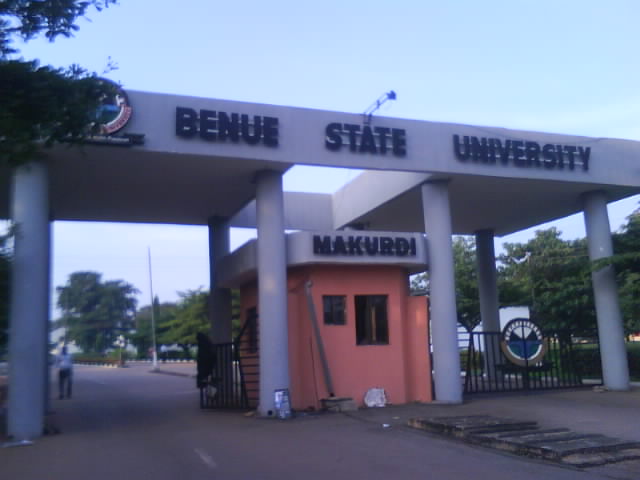
Highlights include Benue State University and Joseph Sarwuan Tarka University.
Weather in Makurdi
Forecast from MET Norway (CC BY 4.0). Full forecast
About Makurdi
Makurdi is the capital of Benue State, located in central Nigeria, and part of the Middle Belt region of central Nigeria. The city is situated along the Benue River. In 2017, Makurdi's urban population was 517,342.
From the Wikipedia article Makurdi (this version), under CC BY-SA 4.0.
Travel tips from other travellers: Makurdi on Wikivoyage (CC BY-SA 4.0).
Things to do3

Joseph Sarwuan Tarka University
School · 2.0 km
University in Makurdi, Nigeria


Museums and landmarks1

Parks, trails and playgrounds1

Where to stay2

History
Makurdi, a town founded in the early 1920s, rose to prominence in 1927 when it became the headquarters of the Benue Province. As a river port, it drew the establishment of trading depots by companies like United Africa Company of Nigeria(UAC) and John Holt plc. Its commercial significance grew even more with the completion and opening of the Railway bridge in 1932.
In the late 19th and early 20th centuries, many Tiv people from nearby communities and towns moved to Makurdi, contributing to its distinct Tiv urban identity. This migration also fostered a growing sense of political awareness among the Tiv. Makurdi emerged as a developing colonial town situated along the River Benue, within Tiv territory.
In 1914, Audu Dan Afoda, a Nupe and Hausa-speaking Muslim who had worked as an interpreter and political agent for various British District officers, was appointed the Sarkin Makurdi (Chief of Makurdi). This decision to place a Hausa speaking Nupe in charge of the Tiv people in the Makurdi area highlighted the British commitment to using Hausa as a key principle of Indirect Rule in the Middle Belt. It supports Mahdi Adamu's claim that the Hausa ethnic unit…is an assimilating ethnic entity and the Hausa language a colonizing one.
From the History section of Makurdi on Wikipedia, under CC BY-SA 4.0.
Churches and places of worship2
Schools, colleges and libraries1
Healthcare1
Map of Makurdi
11 places. The map loads OpenStreetMap tiles when you open it.
Getting there and nearby towns
Makurdi Airport (MDI) is the nearest airport with scheduled flights listed in OpenStreetMap, 11 km away.
- Igbor 33 km south, about 33 min by car
- Aliade 49 km south, about 49 min by car
- Gboko 70 km southeast, about 1 h 15 min by car
- Ugbokpo 71 km west, about 1 h 15 min by car
- Yandev 71 km southeast, about 1 h 15 min by car
- Doma 76 km north, about 1 h 15 min by car
- Boju 81 km southwest, about 1 h 15 min by car
- Lafia 85 km north, about 1 h 30 min by car
- Ochobo 86 km southwest, about 1 h 30 min by car
Drive times are estimates from straight-line distance, not routes.
Local news
Headlines from INDB.
Reviews, tips and questions
Loading what members have shared...
Sources and licences
- GeoNames (CC BY 4.0): population, coordinates, regions and time zone
- OpenStreetMap contributors (ODbL 1.0): places, airports, map data
- Wikidata (CC0 1.0): elevation, founding date, time zone, website, landmarks and historic places
- Wikimedia Commons (see each image): photos
- Wikipedia (CC BY-SA 4.0): overview and history text
Photo credits
- River Benue (in Makurdi With both Bridges), Ashinze, CC BY-SA 4.0
- Clouds, Makurdi, PVIOO, CC BY-SA 4.0
- North South Railway at Makurdi, Central Nigeria. - panoramio, Pastor Sam, CC BY 3.0
- Sky view, Makurdi, PVIOO, CC BY-SA 4.0
- Train station, Makurdi, PVIOO, CC BY-SA 4.0
- Baobab , Makurdi, PVIOO, CC BY-SA 4.0
- Benue-State-University makurdi, Ukule thomas, CC BY-SA 4.0
- Elixir work, Grinch1997, CC BY-SA 4.0
- River Benue (in Makurdi showing OLD Bridge), Ashinze, CC BY-SA 4.0
- Dr. Akpem, Kayy7200, CC BY 4.0
- A River Benue, Kingmalik100, CC0
- My mom and her school children, Katoskyviral, CC BY-SA 4.0
- River Benue at Sunset, David Nkwa (Nkwafilms), CC BY-SA 4.0
- Interaction between Insects and Plants, PVIOO, CC BY-SA 4.0
- Spore explosion, PVIOO, CC BY-SA 4.0
- There's magic in the skies, Yarden001, CC BY-SA 4.0
- Everyday ends beautifully, Yarden001, CC BY-SA 4.0
- Wikidata 13th Birthday Celebration in Benue 3, Meritkosy, CC BY 4.0
- ISS042-E-249147 - View of Earth, Earth Science and Remote Sensing Unit , Lyndon B. Johnson Space Center, Public domain
- ISS042-E-249148 - View of Earth, Earth Science and Remote Sensing Unit , Lyndon B. Johnson Space Center, Public domain
- ISS042-E-249149 - View of Earth, Earth Science and Remote Sensing Unit , Lyndon B. Johnson Space Center, Public domain
- ISS042-E-249146 - View of Earth, Earth Science and Remote Sensing Unit , Lyndon B. Johnson Space Center, Public domain
- Group picture of me and my mates, Cedars Grove, CC BY-SA 4.0
- Beauty of the skies, Yarden001, CC BY-SA 4.0
- Masked off, Yarden001, CC BY-SA 4.0
- Dragonly, Yarden001, CC BY-SA 4.0
- Mr. Hooper, Yarden001, CC BY-SA 4.0
- Shy Hopper, Yarden001, CC BY-SA 4.0
- Sunsetting magically, Yarden001, CC BY-SA 4.0
- Beautifully ending blessings, Yarden001, CC BY-SA 4.0
- Each day ends in Blessings, Yarden001, CC BY-SA 4.0


Page built November 3, 2026. Spotted a mistake? Tell us or suggest a place.