


North Catasauqua, Pennsylvania
North Catasauqua is a borough of 3,014 people in Northampton County, Pennsylvania, founded in 1731.
Why visit North Catasauqua
Townapedia lists 11 museums and landmarks, 22 parks and trails and 34 places to eat in and around town.
Highlights include George Taylor House and Biery's Port Historic District.
July is the warmest month, with average highs of 86°F; January lows average 22°F, and about 33 inches of snow fall in a normal year.
Weather in North Catasauqua
Forecast from the National Weather Service. Full forecast
About North Catasauqua
North Catasauqua is a borough in Northampton County, Pennsylvania, United States. The borough was founded in 1907. The population of North Catasauqua was 2,971 at the 2020 census. The borough is part of the Lehigh Valley metropolitan area, which had a population of 861,899 and was the 68th-most populous metropolitan area in the U.S. as of the 2020 census.
From the Wikipedia article North Catasauqua, Pennsylvania (this version), under CC BY-SA 4.0.
Museums and landmarks11

George Taylor House
Monument and historic site · National Register of Historic Places · 1.2 mi
U.S. National Historic Landmark listed on the NRHP in Lehigh County
35 South Front Street, Catasauqua

Biery's Port Historic District
Monument and historic site · National Register of Historic Places · 1.0 mi
Historic district in Pennsylvania, United States
Catasauqua Residential Historic District
Monument and historic site · National Register of Historic Places · 0.6 mi
Historic district in Pennsylvania, United States

Coopersburg Historic District
Monument and historic site · National Register of Historic Places · 0.6 mi
Historic district in Coopersburg, PA

Coplay Cement Company Kilns
Museum · National Register of Historic Places · 1.4 mi
Pennsylvania historic place

Dent Hardware Company Factory Complex
Monument and historic site · National Register of Historic Places · 1.6 mi
Historic manufacturing facility in Whitehall Township, Pennsylvania, USA

Helfrich's Springs Grist Mill
Monument and historic site · National Register of Historic Places · 2.8 mi
Watermill in Whitehall Township, United States of America
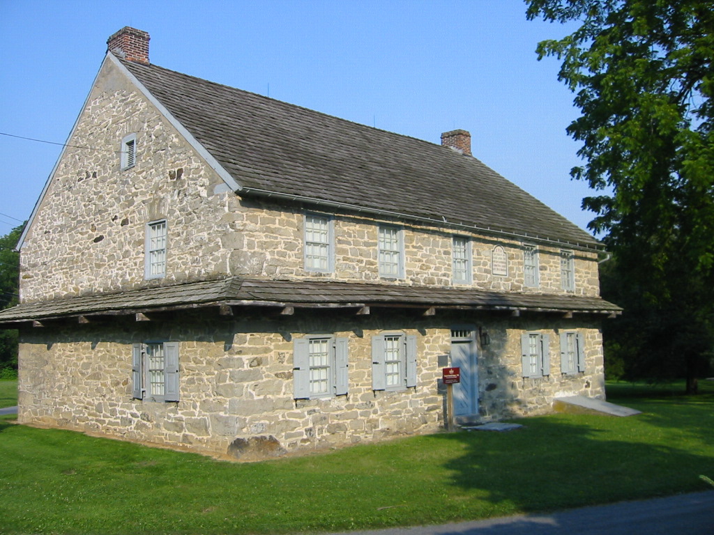


Troxell-Steckel House
Monument and historic site · National Register of Historic Places · 3.3 mi
Historic home located at Egypt, Whitehall Township, Lehigh County, Pennsylvania
Parks, trails and playgrounds22




10 more on the map.
Restaurants and cafes34


Happy Garden
Restaurant · Chinese · 1.3 mi
Mo-Th 11:00-21:30; Tu off; Fr,Sa 11:00-22:30; Su 12:00-21:30
Rozana Mediterranean Restaurant & Banquet Hall
Restaurant · Mediterranean · 1.3 mi
2678 Eberhart Road, Whitehall

Taylor House Brewing
Bar and pub · 1.2 mi
76 Lehigh Street, Catasauqua
Th 16:00-21:00; Fr-Sa 14:00-22:00; Su 14:00-20:00


22 more on the map.
Churches and places of worship19

Redeemed Christian Church of God, Living Spring International Center
Church · 1.2 mi
5 North 3rd Street, Coplay
7 more on the map.
Shopping10
Gas and EV charging6
Schools, colleges and libraries48
Brigadier General Anna Mae Hays El Sch
School · 4.1 mi
1227 W Gordon St, Allentown
Healthcare3
Map of North Catasauqua
153 places. The map loads OpenStreetMap tiles when you open it.
Climate by month
Monthly table
| Month | High | Low | Rain | Snow |
|---|---|---|---|---|
| Jan | 38°F | 22°F | 3.3 in | 9.8 in |
| Feb | 42°F | 23°F | 2.8 in | 10.8 in |
| Mar | 51°F | 30°F | 3.6 in | 6.3 in |
| Apr | 63°F | 40°F | 3.7 in | 0.5 in |
| May | 74°F | 51°F | 3.6 in | 0.0 in |
| Jun | 82°F | 60°F | 4.4 in | 0.0 in |
| Jul | 86°F | 65°F | 5.3 in | 0.0 in |
| Aug | 84°F | 63°F | 4.6 in | 0.0 in |
| Sep | 77°F | 55°F | 4.8 in | 0.0 in |
| Oct | 66°F | 44°F | 4.1 in | 0.2 in |
| Nov | 54°F | 34°F | 3.2 in | 0.9 in |
| Dec | 43°F | 27°F | 3.9 in | 4.6 in |
U.S. Climate Normals 1991-2020 for Allentown Intl Ap Hcn 72517 (2 mi away), NOAA NCEI.
People and cost of living
American Community Survey 5-year estimates, 2020-2024, U.S. Census Bureau. Estimates have margins of error, larger for small towns.
Disaster history
Northampton County has had 17 federal disaster declarations since 2000, most often for hurricanes.
- 2021-09-10: Remnants Of Hurricane Ida (Hurricane)
- 2020-03-30: Covid-19 Pandemic (Biological)
- 2020-03-13: Covid-19 (Biological)
- 2018-11-27: Severe Storms And Flooding (Severe Storm)
- 2016-03-23: Severe Winter Storm And Snowstorm (Snowstorm)
- 2013-01-10: Hurricane Sandy (Hurricane)
OpenFEMA disaster declarations summaries.
Getting there and nearby towns
Lehigh Valley International Airport (ABE) is the nearest airport with scheduled flights listed in OpenStreetMap, 2 miles away.
- Catasauqua 1 mi southeast, about 2 min by car
- Hokendauqua 1 mi west, about 2 min by car
- Coplay 1 mi northwest, about 2 min by car
- Northampton 2 mi north, about 3 min by car
- Stiles 2 mi west, about 3 min by car
- Fullerton 2 mi south, about 4 min by car
- Cementon 3 mi northwest, about 5 min by car
- Egypt 3 mi northwest, about 6 min by car
- Allentown 5 mi south, about 8 min by car
- Bethlehem 6 mi southeast, about 10 min by car
Drive times are estimates from straight-line distance, not routes.
Local news
Headlines from INDB, the NEMICO news database.
Reviews, tips and questions
Loading what members have shared...
Sources and licences
- NCES EDGE (Public domain): public schools
- NOAA NCEI U.S. Climate Normals 1991-2020 (Public domain): climate by month
- OpenFEMA (Public domain): disaster declarations
- OpenStreetMap contributors (ODbL 1.0): places, airports, map data
- U.S. Census Bureau (Public domain): population, income, housing, education, commute
- Wikidata (CC0 1.0): elevation, founding date, time zone, website, landmarks and historic places
- Wikimedia Commons (see each image): photos
- Wikipedia (CC BY-SA 4.0): overview and history text
Photo credits
- Rowhouses in North Catasauqua, Nicholas A. Tonelli, CC BY 2.0
- 2022-09-26 12 46 57 View northwest along Howertown Road between Chapel Street and Grove Street in North Catasauqua, Northampton County, Pennsylvania, Famartin, CC BY-SA 4.0
- 2022-09-26 12 47 07 View southeast along Howertown Road between Grove Street and Chapel Street in North Catasauqua, Northampton County, Pennsylvania, Famartin, CC BY-SA 4.0
- Howertown Road nb entering North Catasauqua, PA, July 2025, Mr. Matté (if there is an issue with this image, contact me using this image's Commons talk page , my Commons user talk page , or my English Wikipedia user talk page ; I'll know about it a lot faster), CC BY-SA 4.0
- North Catasauqua Borough Hall May 2007, North Catasauqua Borough ( talk ), CC BY 3.0
- St. John Fisher Church, North Catasauqua, PA, March 2024, Mr. Matté (if there is an issue with this image, contact me using this image's Commons talk page , my Commons user talk page , or my English Wikipedia user talk page ; I'll know about it a lot faster), CC BY-SA 4.0
- George Taylor House, Allreet, CC BY-SA 3.0
- Coopersburg Historic District 1, PattiParker, CC BY-SA 3.0
- Helfrich Springs Gristmill Lehigh Co PA, Smallbones, CC0
- Coplay Cement Company Kilns in Saylor Park, Nicholas A. Tonelli, CC BY 2.0
- Dent Mill Complex Lehigh Co PA, Smallbones, CC0
- PA-LEHIGH-TroxellSteckelHouseFrontSide, Alphageekpa ( talk ), CC BY-SA 3.0
- Howertown Road nb entering Northampton, PA, July 2025, Mr. Matté (if there is an issue with this image, contact me using this image's Commons talk page , my Commons user talk page , or my English Wikipedia user talk page ; I'll know about it a lot faster), CC BY-SA 4.0
- Entering Northampton, PA on Main Street nb, March 2024, Mr. Matté (if there is an issue with this image, contact me using this image's Commons talk page , my Commons user talk page , or my English Wikipedia user talk page ; I'll know about it a lot faster), CC BY-SA 4.0
- Toyota Celica ST Sunchaser 01, Jacob Frey 4A, CC BY 2.0
- Toyota Celica ST Sunchaser 02, Jacob Frey 4A, CC BY 2.0
- Toyota Corolla GT-S (40594393994), Jacob Frey 4A, CC BY 2.0
- David Thomas House, Pytor, CC BY-SA 3.0
- Dery Mansion, Pytor, CC BY-SA 3.0
- Catasauqua, PA municipal complex, March 2024, Mr. Matté (if there is an issue with this image, contact me using this image's Commons talk page , my Commons user talk page , or my English Wikipedia user talk page ; I'll know about it a lot faster), CC BY-SA 4.0
- Howertown Road nb, Catasauqua, PA, July 2025, Mr. Matté (if there is an issue with this image, contact me using this image's Commons talk page , my Commons user talk page , or my English Wikipedia user talk page ; I'll know about it a lot faster), CC BY-SA 4.0
- Area View around Catasauqua Creek and the Crane Iron Works in 2017-USGS, Fra nkB, Public domain
- Catasauqua Creek watercourse in Catasaugua, PA+source+insert overall area in 2017-USGS, Fra nkB, Public domain
- Catasauqua Creek watercourse in Catasaugua, PA+source+its direct distance-USGS, Fra nkB, Public domain
- 10th Street stone house, Catasauqua, PA, July 2025, Mr. Matté (if there is an issue with this image, contact me using this image's Commons talk page , my Commons user talk page , or my English Wikipedia user talk page ; I'll know about it a lot faster), CC BY-SA 4.0
- Biery's Port Lehigh Co PA 3, Smallbones, CC0
- Dery Silk Mill Lehigh Co PA, Smallbones, CC0
- Biery's Port Lehigh Co PA, Smallbones, CC0
- Biery's Port Lehigh Co PA 2, Smallbones, CC0
- 2022-09-26 12 39 39 View southwest along Race Street between Front Street and Lehigh Street in Catasauqua, Lehigh County, Pennsylvania, Famartin, CC BY-SA 4.0
- 2022-09-26 12 38 18 View northeast along Race Street between Lehigh Street and Front Street in Catasauqua, Lehigh County, Pennsylvania, Famartin, CC BY-SA 4.0
- Race Street wb, Catasauqua, PA, July 2025, Mr. Matté (if there is an issue with this image, contact me using this image's Commons talk page , my Commons user talk page , or my English Wikipedia user talk page ; I'll know about it a lot faster), CC BY-SA 4.0
- Catasauqua High School, PA, July 2025, Mr. Matté (if there is an issue with this image, contact me using this image's Commons talk page , my Commons user talk page , or my English Wikipedia user talk page ; I'll know about it a lot faster), CC BY-SA 4.0
- Northampton-Coplay Bridge wb, March 2024, Mr. Matté (if there is an issue with this image, contact me using this image's Commons talk page , my Commons user talk page , or my English Wikipedia user talk page ; I'll know about it a lot faster), CC BY-SA 4.0
- Entering Coplay, PA from east, March 2024, Mr. Matté (if there is an issue with this image, contact me using this image's Commons talk page , my Commons user talk page , or my English Wikipedia user talk page ; I'll know about it a lot faster), CC BY-SA 4.0
- Entering Catasauqua, PA on Race Street wb, July 2025, Mr. Matté (if there is an issue with this image, contact me using this image's Commons talk page , my Commons user talk page , or my English Wikipedia user talk page ; I'll know about it a lot faster), CC BY-SA 4.0
- 2022-09-26 12 55 44 View southwest along Chestnut Street between Bird Alley and Third Street in Coplay, Lehigh County, Pennsylvania, Famartin, CC BY-SA 4.0
- 2022-09-26 12 56 04 View northeast along Chestnut Street between Third Street and Bird Alley in Coplay, Lehigh County, Pennsylvania, Famartin, CC BY-SA 4.0
- Saylor Park (1) (7974308619), Nicholas A. Tonelli from Northeast Pennsylvania, USA, CC BY 2.0
- Coplay Kilms (5903691116), MetaMethod, CC BY 2.0


Page built October 30, 2026. Spotted a mistake? Tell us or suggest a place.