


Stiles, Pennsylvania
Stiles is a community of 1,441 people in Lehigh County, Pennsylvania.
Why visit Stiles
Townapedia lists 12 museums and landmarks, 18 parks and trails, 30 places to eat and 2 attractions in and around town.
Highlights include Biery's Port Historic District, Catasauqua Residential Historic District and Whitehall Parkway.
July is the warmest month, with average highs of 86°F; January lows average 22°F, and about 33 inches of snow fall in a normal year.
Weather in Stiles
Forecast from the National Weather Service. Full forecast
About Stiles
Stiles is an unincorporated community and census-designated place (CDP) that is located in Whitehall Township, Pennsylvania. As of the 2010 census, the population was 1,113.
From the Wikipedia article Stiles, Pennsylvania (this version), under CC BY-SA 4.0.
Things to do2

Museums and landmarks12

Biery's Port Historic District
Monument and historic site · National Register of Historic Places · 2.4 mi
Historic district in Pennsylvania, United States

Catasauqua Residential Historic District
Monument and historic site · National Register of Historic Places · 1.9 mi
Historic district in Pennsylvania, United States

Cold Spring Bridge
Bridge · National Register of Historic Places · 2.4 mi
Bridge in United States of America

Coopersburg Historic District
Monument and historic site · National Register of Historic Places · 1.9 mi
Historic district in Coopersburg, PA

Coplay Cement Company Kilns
Museum · National Register of Historic Places · 0.9 mi
Pennsylvania historic place

Dent Hardware Company Factory Complex
Monument and historic site · National Register of Historic Places · 2.5 mi
Historic manufacturing facility in Whitehall Township, Pennsylvania, USA
George Taylor House
Monument and historic site · National Register of Historic Places · 2.5 mi
U.S. National Historic Landmark listed on the NRHP in Lehigh County

Helfrich's Springs Grist Mill
Monument and historic site · National Register of Historic Places · 2.9 mi
Watermill in Whitehall Township, United States of America
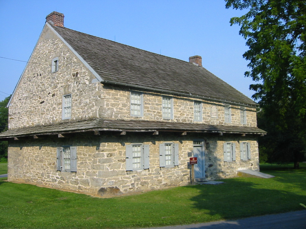


Troxell-Steckel House
Monument and historic site · National Register of Historic Places · 1.6 mi
Historic home located at Egypt, Whitehall Township, Lehigh County, Pennsylvania

Parks, trails and playgrounds18



6 more on the map.
Restaurants and cafes30

Happy Garden
Restaurant · Chinese · 0.9 mi
Mo-Th 11:00-21:30; Tu off; Fr,Sa 11:00-22:30; Su 12:00-21:30

Rozana Mediterranean Restaurant & Banquet Hall
Restaurant · Mediterranean · 1.3 mi
2678 Eberhart Road, Whitehall


Metro & John's Cafe
Restaurant · Mexican · 1.4 mi
1616 Main Street, Catasauqua
Just Chill Creamery
Ice cream · 1.5 mi
5503 Macarthur Road, Whitehall
Palace Pizza & Sports Bar
Restaurant · Pizza, Italian · 1.0 mi
3690 Lehigh Street, Whitehall
18 more on the map.
Churches and places of worship16
Faith Evangelical Lutheran Church
Church · Evangelical Lutheran · 0.5 mi
3355 MacArthur Road, Whitehall
Holy Trinity Roman Catholic Church
Church · Roman Catholic · 1.5 mi
4102 South Church Street, Whitehall
Saint John's United Church of Christ
Church · United Church Of Christ · 1.3 mi
2918 MacArthur Road, Whitehall
Redeemed Christian Church of God, Living Spring International Center
Church · 0.9 mi
5 North 3rd Street, Coplay
Shopping7
Gas and EV charging8
Schools, colleges and libraries47
Brigadier General Anna Mae Hays El Sch
School · 4.4 mi
1227 W Gordon St, Allentown
Healthcare4
Map of Stiles
144 places. The map loads OpenStreetMap tiles when you open it.
Climate by month
Monthly table
| Month | High | Low | Rain | Snow |
|---|---|---|---|---|
| Jan | 38°F | 22°F | 3.3 in | 9.8 in |
| Feb | 42°F | 23°F | 2.8 in | 10.8 in |
| Mar | 51°F | 30°F | 3.6 in | 6.3 in |
| Apr | 63°F | 40°F | 3.7 in | 0.5 in |
| May | 74°F | 51°F | 3.6 in | 0.0 in |
| Jun | 82°F | 60°F | 4.4 in | 0.0 in |
| Jul | 86°F | 65°F | 5.3 in | 0.0 in |
| Aug | 84°F | 63°F | 4.6 in | 0.0 in |
| Sep | 77°F | 55°F | 4.8 in | 0.0 in |
| Oct | 66°F | 44°F | 4.1 in | 0.2 in |
| Nov | 54°F | 34°F | 3.2 in | 0.9 in |
| Dec | 43°F | 27°F | 3.9 in | 4.6 in |
U.S. Climate Normals 1991-2020 for Allentown Intl Ap Hcn 72517 (3 mi away), NOAA NCEI.
People and cost of living
American Community Survey 5-year estimates, 2020-2024, U.S. Census Bureau. Estimates have margins of error, larger for small towns.
Disaster history
Lehigh County has had 11 federal disaster declarations since 2000, most often for hurricanes.
- 2020-03-30: Covid-19 Pandemic (Biological)
- 2020-03-13: Covid-19 (Biological)
- 2016-03-23: Severe Winter Storm And Snowstorm (Snowstorm)
- 2012-10-29: Hurricane Sandy (Hurricane)
- 2011-09-08: Remnants Of Tropical Storm Lee (Flood)
- 2011-09-03: Hurricane Irene (Hurricane)
OpenFEMA disaster declarations summaries.
Getting there and nearby towns
Lehigh Valley International Airport (ABE) is the nearest airport with scheduled flights listed in OpenStreetMap, 4 miles away.
- Cementon 2 mi north, about 3 min by car
- Northampton 2 mi northeast, about 3 min by car
- Fullerton 3 mi southeast, about 5 min by car
- Allentown 5 mi south, about 8 min by car
- Cherryville 6 mi north, about 10 min by car
- Bethlehem 8 mi east, about 13 min by car
- Emmaus 9 mi south, about 15 min by car
- DeSales University 11 mi southeast, about 18 min by car
- Easton 15 mi east, about 24 min by car
- Phillipsburg 17 mi east, about 28 min by car
Drive times are estimates from straight-line distance, not routes.
Local news
Headlines from INDB, the NEMICO news database.
Reviews, tips and questions
Loading what members have shared...
Sources and licences
- NCES EDGE (Public domain): public schools
- NOAA NCEI U.S. Climate Normals 1991-2020 (Public domain): climate by month
- OpenFEMA (Public domain): disaster declarations
- OpenStreetMap contributors (ODbL 1.0): places, airports, map data
- U.S. Census Bureau (Public domain): population, income, housing, education, commute
- Wikidata (CC0 1.0): landmarks and historic places
- Wikimedia Commons (see each image): photos
- Wikipedia (CC BY-SA 4.0): overview and history text
Photo credits
- Coopersburg Historic District 1, PattiParker, CC BY-SA 3.0
- Helfrich Springs Gristmill Lehigh Co PA, Smallbones, CC0
- Coplay Cement Company Kilns in Saylor Park, Nicholas A. Tonelli, CC BY 2.0
- George Taylor House, Allreet, CC BY-SA 3.0
- Cold Spring Bridge Lehigh Co PA, Smallbones, CC0
- Dent Mill Complex Lehigh Co PA, Smallbones, CC0
- Dery Silk Mill Lehigh Co PA, Smallbones, CC0
- PA-LEHIGH-TroxellSteckelHouseFrontSide, Alphageekpa ( talk ), CC BY-SA 3.0
- David Thomas House, Pytor, CC BY-SA 3.0
- Whitehall Twp., Lehigh Co., PA municipal building, Aug. 2023, Mr. Matté (if there is an issue with this image, contact me using this image's Commons talk page , my Commons user talk page , or my English Wikipedia user talk page ; I'll know about it a lot faster), CC BY-SA 4.0
- 2022-09-26 12 56 04 View northeast along Chestnut Street between Third Street and Bird Alley in Coplay, Lehigh County, Pennsylvania, Famartin, CC BY-SA 4.0
- 2022-09-26 12 55 44 View southwest along Chestnut Street between Bird Alley and Third Street in Coplay, Lehigh County, Pennsylvania, Famartin, CC BY-SA 4.0
- Saylor Park (1) (7974308619), Nicholas A. Tonelli from Northeast Pennsylvania, USA, CC BY 2.0
- Coplay Cement Company Kilns 2024, JR0576, CC0
- Coplay Kilms (5903691116), MetaMethod, CC BY 2.0
- Entering Coplay, PA from east, March 2024, Mr. Matté (if there is an issue with this image, contact me using this image's Commons talk page , my Commons user talk page , or my English Wikipedia user talk page ; I'll know about it a lot faster), CC BY-SA 4.0
- Northampton-Coplay Bridge wb, March 2024, Mr. Matté (if there is an issue with this image, contact me using this image's Commons talk page , my Commons user talk page , or my English Wikipedia user talk page ; I'll know about it a lot faster), CC BY-SA 4.0
- Jacob Mickley family monument, St. John's Union Cemetery, Mickleys, PA - detail, Zeete, CC BY-SA 4.0
- John Jacob Mickley (1737–1808) gravestone, St. John's Union Cemetery, Mickleys, PA, Zeete, CC BY-SA 4.0
- John Jacob Mickley (1697–1769) gravestone, St. John's Union Cemetery, Mickleys, PA - north side, Zeete, CC BY-SA 4.0
- Jacob and John Jacob Mickley family monuments, St. John's Union Cemetery, Mickleys, PA, Zeete, CC BY-SA 4.0
- John Jacob Mickley family monument, St. John's Union Cemetery, Mickleys, PA, Zeete, CC BY-SA 4.0
- John Jacob Mickley (1697–1769) gravestone, St. John's Union Cemetery, Mickleys, PA - south side, Zeete, CC BY-SA 4.0
- Jacob Mickley gravestone, St. John's Union Cemetery, Mickleys, PA, Zeete, CC BY-SA 4.0
- Jacob Mickley family plot, St. John's Union Cemetery, Mickleys, PA, Zeete, CC BY-SA 4.0
- St. John's Union Cemetery, Mickleys, PA - area view, Zeete, CC BY-SA 4.0
- St. John's United Church of Christ, Mickleys, PA - cornerstone, Zeete, CC BY-SA 4.0
- St. John's United Church of Christ, Mickleys, PA, Zeete, CC BY-SA 4.0
- St. John's United Church of Christ, Mickleys, PA - looking north, Zeete, CC BY-SA 4.0
- Entering Northampton, PA on Main Street nb, March 2024, Mr. Matté (if there is an issue with this image, contact me using this image's Commons talk page , my Commons user talk page , or my English Wikipedia user talk page ; I'll know about it a lot faster), CC BY-SA 4.0
- 2022-09-25 10 16 50 View north along Pennsylvania State Route 145 (MacArthur Road) at the exit for Eberhart Road in Whitehall Township, Lehigh County, Pennsylvania, Famartin, CC BY-SA 4.0
- St. John Fisher Church, North Catasauqua, PA, March 2024, Mr. Matté (if there is an issue with this image, contact me using this image's Commons talk page , my Commons user talk page , or my English Wikipedia user talk page ; I'll know about it a lot faster), CC BY-SA 4.0
- Churchyard, Egypt Community Church, Egypt, PA, Zeete, CC BY-SA 4.0
- 2022-09-25 10 47 14 View south along Pennsylvania State Route 145 (MacArthur Road) just south of Pennsylvania State Route 329 (Main Street) in Whitehall Township, Lehigh County, Pennsylvania, Famartin, CC BY-SA 4.0
- 1830 Haus, Egypt, PA, Zeete, CC BY-SA 4.0
- Egypt Community Church, Egypt, PA - looking east, Zeete, CC BY-SA 4.0
- PA 329 wb Egypt (1), Feb. 2024, Mr. Matté (if there is an issue with this image, contact me using this image's Commons talk page , my Commons user talk page , or my English Wikipedia user talk page ; I'll know about it a lot faster), CC BY-SA 4.0


Page built October 30, 2026. Spotted a mistake? Tell us or suggest a place.