


Why visit Oakland
Townapedia lists 54 museums and landmarks, 25 parks and trails, 24 places to eat, 1 place to stay and 12 attractions in and around town.
Highlights include Campgaw Mountain, Millstone Hill, Aaron Winters House and Abraham Van Gelder House.
July is the warmest month, with average highs of 84°F; January lows average 20°F.
Weather in Oakland
Forecast from the National Weather Service. Full forecast
About Oakland
Oakland is a borough in Bergen County, in the U.S. state of New Jersey and a suburb of New York City. As of the 2020 United States census, the borough's population was 12,748, a decrease of six people from the 2010 census count of 12,754, which in turn reflected an increase of 288 (+2.3%) from the 12,466 counted in the 2000 census.
From the Wikipedia article Oakland, New Jersey (this version), under CC BY-SA 4.0.
Things to do12

Museums and landmarks54

Aaron Winters House
Monument and historic site · National Register of Historic Places · 2.7 mi
Historic house in Franklin Lakes, New Jersey

Abraham Van Gelder House
Monument and historic site · National Register of Historic Places · 4.0 mi
House in Ramsey, New Jersey

Ackerman-Boyd House
Monument and historic site · National Register of Historic Places · 2.2 mi
United States historic place

Albert Pulis House
Monument and historic site · National Register of Historic Places · 2.3 mi
Historic house in Franklin Lakes, New Jersey

Albert Van Blarcom House
Monument and historic site · National Register of Historic Places · 4.5 mi
House in Wyckoff, New Jersey

Blauvelt House
Monument and historic site · National Register of Historic Places · 3.1 mi
Historic house in Franklin Lakes, New Jersey

Crocker-McMillin Mansion-Immaculate Conception Seminary
Monument and historic site · National Register of Historic Places · 3.9 mi
Historic house in New Jersey, United States
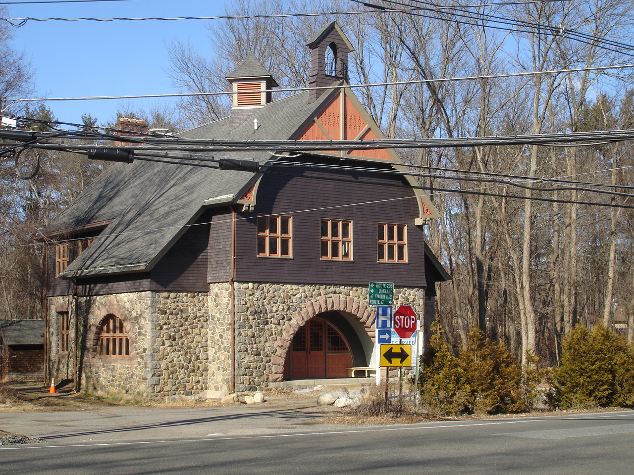
Darlington Schoolhouse
Monument and historic site · National Register of Historic Places · 4.4 mi
School building in New Jersey, United States of America

David Van Gelder House
Monument and historic site · National Register of Historic Places · 4.0 mi
Historic house in New Jersey, United States

De Gray House
Monument and historic site · National Register of Historic Places · 3.0 mi
Historic house in New Jersey, United States

Demarest House
Monument and historic site · National Register of Historic Places · 1.0 mi
Historic house in Oakland, New Jersey, USA


Demarest-Hopper House
Monument and historic site · National Register of Historic Places · 2.1 mi
Historic house in Bergen County, New Jersey
42 more on the map.
Parks, trails and playgrounds25


Pompton Aquatic Park
Park · 4.2 mi
Park in New Jersey, United States of America

13 more on the map.
Restaurants and cafes24


The Chef's Table
Restaurant · Fine Dining · 2.0 mi
Fashionable Parisian-style cafe in a strip mall turning out traditional French fowl & fish dishes. More info at:...
754 Franklin Avenue, Franklin Lakes
Mo off, Tu-Su 11:45-14:30, 19:00-21:00, Sa 17:00 - 22:00, Su 16:00-20:30


12 more on the map.
History
The Van Allen House was built in 1748 and was a stop for George Washington and his troops in 1777.
From the 1940s through the end of the 1960s a summer bungalow colony was developed in a valley in West Oakland on the Ramapo River. This was a refuge for a close-knit group of several score families from the summer heat of New York City and urban New Jersey. During the summer months, the New York, Susquehanna and Western Railroad provided service at a West Oakland passenger station. This colony was located on the road between Oakland and Pompton Lakes, near a training camp for boxers. In the early morning, a resident could see Joe Louis or Sugar Ray Robinson, among others, running past the summer homes. One of these resorts was called Pleasureland and had pools and slides, including a concert venue for bands. It was popular in the 1980s until August 4th 1985 when a bus tour from NYC came to celebrate Jamaican Independence day and there was a shootout. The resort was then incorporated into the Great Oak Park with trails for residents.
From the History section of Oakland, New Jersey on Wikipedia, under CC BY-SA 4.0.
Where to stay1
Churches and places of worship6
Reformed Dutch Church of Wyckoff
Church · National Register of Historic Places · 3.9 mi
Shopping8
Gas and EV charging5
Schools, colleges and libraries46
Franklin Lakes Public Library
Library · 2.4 mi
470 De Korte Drive, Franklin Lakes
Healthcare1
Map of Oakland
182 places. The map loads OpenStreetMap tiles when you open it.
Climate by month
Monthly table
| Month | High | Low | Rain |
|---|---|---|---|
| Jan | 38°F | 20°F | 3.4 in |
| Feb | 40°F | 20°F | 2.7 in |
| Mar | 48°F | 29°F | 3.9 in |
| Apr | 60°F | 39°F | 4.2 in |
| May | 71°F | 50°F | 3.6 in |
| Jun | 79°F | 58°F | 5.1 in |
| Jul | 84°F | 64°F | 4.7 in |
| Aug | 83°F | 63°F | 4.6 in |
| Sep | 76°F | 56°F | 4.0 in |
| Oct | 64°F | 43°F | 4.4 in |
| Nov | 53°F | 35°F | 3.8 in |
| Dec | 43°F | 27°F | 4.0 in |
U.S. Climate Normals 1991-2020 for Wanaque Raymond Dam (3 mi away), NOAA NCEI.
People and cost of living
American Community Survey 5-year estimates, 2020-2024, U.S. Census Bureau. Estimates have margins of error, larger for small towns.
Disaster history
Bergen County has had 21 federal disaster declarations since 2000, most often for hurricanes.
- 2021-09-05: Remnants Of Hurricane Ida (Hurricane)
- 2021-09-02: Remnants Of Hurricane Ida (Hurricane)
- 2020-12-11: Tropical Storm Isaias (Hurricane)
- 2020-03-25: Covid-19 Pandemic (Biological)
- 2020-03-13: Covid-19 (Biological)
- 2018-06-08: Severe Winter Storm And Snowstorm (Severe Storm)
OpenFEMA disaster declarations summaries.
Getting there and nearby towns
Essex County Airport (CDW) is the nearest airport with scheduled flights listed in OpenStreetMap, 11 miles away.
- Franklin Lakes 2 mi southeast, about 4 min by car
- Glen Rock 8 mi southeast, about 13 min by car
- Lincoln Park 8 mi southwest, about 13 min by car
- Kinnelon 8 mi southwest, about 13 min by car
- Paterson 9 mi southeast, about 14 min by car
- Hillsdale 10 mi east, about 17 min by car
- Lake Hiawatha 13 mi southwest, about 20 min by car
- Maywood 13 mi southeast, about 21 min by car
- Oak Ridge 14 mi west, about 22 min by car
- Hasbrouck Heights 14 mi southeast, about 23 min by car
Drive times are estimates from straight-line distance, not routes.
Local news
Headlines from INDB, the NEMICO news database.
Reviews, tips and questions
Loading what members have shared...
Sources and licences
- NCES EDGE (Public domain): public schools
- NOAA NCEI U.S. Climate Normals 1991-2020 (Public domain): climate by month
- OpenFEMA (Public domain): disaster declarations
- OpenStreetMap contributors (ODbL 1.0): places, airports, map data
- U.S. Census Bureau (Public domain): population, income, housing, education, commute
- Wikidata (CC0 1.0): elevation, founding date, time zone, website, landmarks and historic places
- Wikimedia Commons (see each image): photos
- Wikipedia (CC BY-SA 4.0): overview and history text
Photo credits
- Demarest House, Oakland, Bergen County, NJ, JERRYE & ROY KLOTZ M.D., CC BY-SA 4.0
- 2021-07-24 15 38 02 View north along U.S. Route 202 (Ramapo Valley Road) from the overpass for Interstate 287 in Oakland, Bergen County, New Jersey, Famartin, CC BY-SA 4.0
- 2021-07-24 15 35 05 View south along U.S. Route 202 (Ramapo Valley Road) from the overpass for Interstate 287 in Oakland, Bergen County, New Jersey, Famartin, CC BY-SA 4.0
- 2020-07-08 14 06 10 View north along Interstate 287 at Exit 58 (U.S. Route 202, Oakland) in Oakland, Bergen County, New Jersey, Famartin, CC BY-SA 4.0
- 2020-07-13 07 56 28 View south along Interstate 287 at Exit 57 (Skyline Drive, Ringwood) in Oakland, Bergen County, New Jersey, Famartin, CC BY-SA 4.0
- 2020-07-13 07 54 05 View south along Interstate 287 at Exit 58 (U.S. Route 202, Oakland) in Oakland, Bergen County, New Jersey, Famartin, CC BY-SA 4.0
- 2018-07-19 18 48 41 View south along Interstate 287 at Exit 58 (U.S. Route 202, Oakland) in Oakland, Bergen County, New Jersey, Famartin, CC BY-SA 4.0
- Oakland, NJ Municipal Building, Nov. 2025, Mr. Matté (if there is an issue with this image, contact me using this image's Commons talk page , my Commons user talk page , or my English Wikipedia user talk page ; I'll know about it a lot faster), CC BY-SA 4.0
- 2018-07-19 17 36 55 View south along U.S. Route 202 (Ramapo Valley Road) between Walnut Street and Lawlor Drive in Oakland, Bergen County, New Jersey, Famartin, CC BY-SA 4.0
- 2018-07-21 11 28 54 View north along New Jersey State Route 208 just south of Interstate 287 in Oakland, Bergen County, New Jersey, Famartin, CC BY-SA 4.0
- ACKERMAN-BOYD HOUSE, FRANKLIN LAKES, BERGEN COUNTY, NJ, JERRYE & ROY KLOTZ MD, CC BY-SA 4.0
- DUTCH REFORMED CHURCH OF WYCKOFF, BERGEN COUNTY, NJ, JERRYE & ROY KLOTZ M.D., CC BY-SA 4.0
- VAN BLARCOM HOUSE, FRANKLIN LAKES, BERGEN COUNTY, NJ, JERRYE & ROY KLOTZ MD, CC BY-SA 4.0
- JOHN BARTHOLF HOUSE, MAHWAH, BERGEN COUNTY, JERRYE & ROY KLOTZ M.D., CC BY-SA 4.0
- ALBERT VAN BLARCOM HOUSE, WYCKOFF, BERGEN COUNTY, JERRYE & ROY KLOTZ MD, CC BY-SA 4.0
- HENDRICK VAN ALLEN HOUSE, OAKLAND, BERGEN COUNTY, NJ, JERRYE & ROY KLOTZ M.D., CC BY-SA 4.0
- CROCKER-McMILLIN MANSION - IMMACULATE CONCEPTION SEMINARY, MAHWAH, BERGEN COUNTY, JERRYE & ROY KLOTZ M.D., CC BY-SA 4.0
- VAN HOUTEN-ACKERMAN HOUSE, WYCKOFF, BERGEN COUNTY, JERRYE & ROY KLOTZ MD, CC BY-SA 4.0
- VanRiper-Hopper House, Lithium6ion, Public domain
- STORMS HOUSE, FRANKLIN LAKES, BERGEN COUNTY, NJ, JERRYE & ROY KLOTZ MD, CC BY-SA 4.0
- DarlingtonSchoolhouse, KForce at English Wikipedia, CC BY-SA 3.0
- VAN WINKLE HOUSE, FRANKLIN LAKES, BERGEN COUNTY, NJ, JERRYE & ROY KLOTZ MD, CC BY-SA 4.0
- David Van Gelder House, Elle829, CC BY-SA 3.0
- WINTERS-COURTER HOUSE, FRANKLIN LAKES, BERGEN COUNTY, JERRYE & ROY KLOTZ MD, CC BY-SA 4.0
- Schuyler-Colfax House, Nathaniel R. Ewan, Public domain
- VAN VOORHIS QUACKENBUSH HOUSE, BERGEN COUNTY, NJ, JERRYE & ROY KLOTZ M.D., CC BY-SA 4.0
- FOLLY HOUSE, WYCKOFF, BERGER COUNTY, JERRYE & ROY KLOTZ MD, CC BY-SA 4.0
- DE GRAY HOUSE, FRANKLIN LAKES, BERGEN COUNTY, NJ, JERRYE & ROY KLOTZ MD, CC BY-SA 4.0
- Aaron Winters House, Franklin Lakes, NJ, Unknown author Unknown author, Public domain
- DEMAREST-HOPPER HOUSE, OAKLAND, BERGEN COUNTY, NJ, JERRYE & ROY KLOTZ M.D., CC BY-SA 4.0
- Van Houten House, Franklin Lakes, NJ, Karel de Waal Malefyt, CC BY-SA 4.0
- Abraham Gelder House, Elle829, CC BY-SA 3.0
- FranklinLakesNJ BlauveltHouse, Magicpiano, CC BY-SA 4.0
- ALBERT PULIS HOUSE, FRANKLIN LAKES, BERGEN COUNTY, JERRYE & ROY KLOTZ MD, CC BY-SA 4.0
- MASKER HOUSE, WYCKOFF, BERGEN COUNTY, NJ, JERRYE & ROY KLOTZ MD, CC BY-SA 4.0
- VAN KOERT-WINTERS HOUSE, FRANKLIN LAKES, BERGEN COUNTY, JERRYE & ROY KLOTZ MD, CC BY-SA 4.0
- VanGelderHouse, Unknown author Unknown author, Public domain
- Vanderbeck House, Elle829, CC BY-SA 3.0
- JACOBUS S. DEMAREST HOUSE, OAKLAND, BERGEN COUNTY, NJ, JERRYE & ROY KLOTZ M.D., CC BY-SA 4.0
- ISAAC BOGERT HOUSE, MAHWAH, BERGEN COUNTY, NJ, JERRYE & ROY KLOTZ M.D., CC BY-SA 4.0


Page built October 30, 2026. Spotted a mistake? Tell us or suggest a place.