


Ocean Grove, Massachusetts
Ocean Grove is a community of 3,453 people in Bristol County, Massachusetts.
Why visit Ocean Grove
Townapedia lists 71 museums and landmarks, 6 parks and trails, 6 places to eat, 1 place to stay and 4 attractions in and around town.
Highlights include Borden Flats Light, Charles M. Braga Jr. Memorial Bridge, A. B. Chace Rowhouses and A. J. Borden Building.
July is the warmest month, with average highs of 85°F; January lows average 24°F, and about 38 inches of snow fall in a normal year.
Weather in Ocean Grove
Forecast from the National Weather Service. Full forecast
About Ocean Grove
Ocean Grove is a census-designated place (CDP) in the town of Swansea in Bristol County, Massachusetts, United States, on the north shore of Mount Hope Bay near the Cole River. The population was 2,811 at the 2010 census, and 2,904 as of the 2020 census.
From the Wikipedia article Ocean Grove, Massachusetts (this version), under CC BY-SA 4.0.
Things to do4

Borden Flats Light
Lighthouse · National Register of Historic Places · 2.5 mi
Lighthouse in Massachusetts, United States

Charles M. Braga Jr. Memorial Bridge
Bridge · 2.7 mi
Bridge in Fall River, Massachusetts
Slade's Ferry Bridge
Bridge · 2.7 mi
Bridge in Fall River, Massachusetts, United States of America

Museums and landmarks71
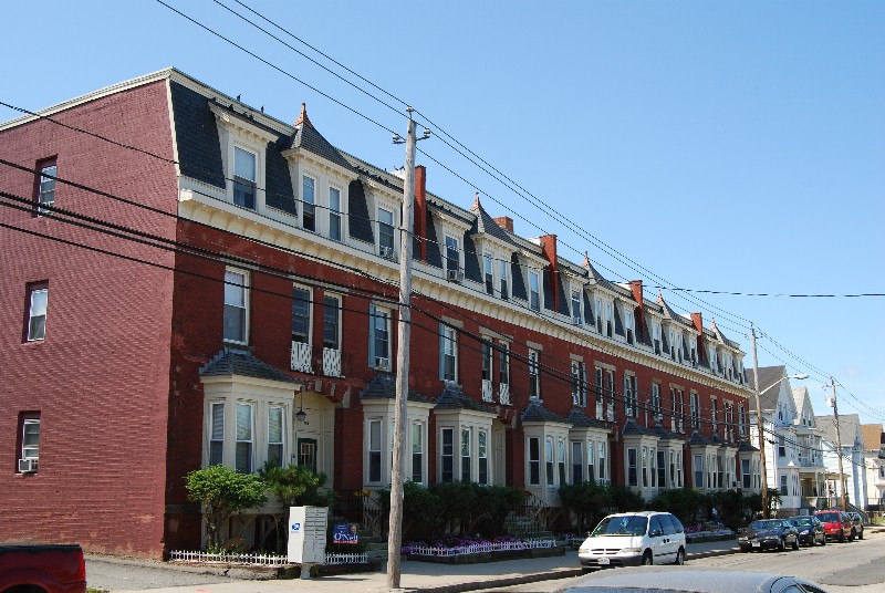
A. B. Chace Rowhouses
Monument and historic site · National Register of Historic Places · 2.8 mi
Terrace of houses in Fall River, Massachusetts

A. J. Borden Building
Monument and historic site · National Register of Historic Places · 3.4 mi
Building in Massachusetts, United States

Al Mac's Diner-Restaurant
Monument and historic site · National Register of Historic Places · 2.9 mi
Diner in Fall River, Massachusetts

Algonquin Printing Co.
Monument and historic site · National Register of Historic Places · 2.8 mi
Historic industrial complex in Fall River, Massachusetts
American Printing Co. and Metacomet Mill
Monument and historic site · National Register of Historic Places · 3.1 mi
The oldest textile mill in Fall River, Massachusetts.

Ariadne J. and Mary A. Borden House
Monument and historic site · National Register of Historic Places · 2.6 mi
Fall River, Massachusetts, listed on the NRHP in Massachusetts

Ashworth Brothers Mill
Monument and historic site · National Register of Historic Places · 2.9 mi
Textile mill in Fall River, Massachusetts
B.M.C. Durfee High School
Monument and historic site · National Register of Historic Places · 3.3 mi
High school building in Fall River, Massachusetts
Bark Street School
Monument and historic site · National Register of Historic Places · 2.7 mi
School building in Swansea, Massachusetts, United States
Barnabus Blossom House
Monument and historic site · National Register of Historic Places · 3.2 mi
Historic house in Massachusetts, United States


Belmont Club
Monument and historic site · National Register of Historic Places · 3.3 mi
Historic house in Fall River, Massachusetts
Bend of the Lane
Monument and historic site · National Register of Historic Places · 1.0 mi
Building in Massachusetts, United States
59 more on the map.
Parks, trails and playgrounds6

Kennedy Park
Park · National Register of Historic Places · 3.1 mi
Park in Massachusetts, United States of America




Restaurants and cafes6

Friendly's
Diner · American · 1.4 mi
748 Grand Army of the Republic Highway, Swansea
Mo-Th 11:00-21:30; Fr-Sa 11:00-22:00; Su 11:00-21:30


McDonald's
Fast food · Burger · 1.4 mi
631 Grand Army of the Republic Highway, Swansea
Mo-Sa 05:00-23:00; Su 06:00-23:00
Where to stay1
Churches and places of worship5
Central Congregational Church
Church · National Register of Historic Places · 3.4 mi
Santo Christo Church
Church · National Register of Historic Places · 3.1 mi
St. Anne's Church and Parish Complex
Church · National Register of Historic Places · 3.4 mi
St. Louis Church
Church · National Register of Historic Places · 3.1 mi
St. Mary's Cathedral and Rectory
Church · National Register of Historic Places · 3.4 mi
Shopping2
Gas and EV charging4
Schools, colleges and libraries45
Carlton M. Viveiros Elementary School
School · 3.4 mi
525 Slade Street, Fall River
Diman Regional Vocational Technical High
School · 4.8 mi
251 Stonehaven Rd, Fall River
Map of Ocean Grove
144 places. The map loads OpenStreetMap tiles when you open it.
Climate by month
Monthly table
| Month | High | Low | Rain | Snow |
|---|---|---|---|---|
| Jan | 38°F | 24°F | 4.0 in | 10.9 in |
| Feb | 41°F | 24°F | 3.8 in | 11.3 in |
| Mar | 49°F | 30°F | 5.5 in | 7.4 in |
| Apr | 60°F | 39°F | 4.5 in | 0.6 in |
| May | 70°F | 49°F | 3.6 in | 0.0 in |
| Jun | 79°F | 58°F | 3.7 in | 0.0 in |
| Jul | 85°F | 65°F | 3.0 in | 0.0 in |
| Aug | 84°F | 64°F | 3.8 in | 0.0 in |
| Sep | 77°F | 57°F | 3.9 in | 0.0 in |
| Oct | 64°F | 47°F | 4.5 in | 0.0 in |
| Nov | 53°F | 37°F | 4.1 in | 0.6 in |
| Dec | 43°F | 30°F | 4.9 in | 7.3 in |
U.S. Climate Normals 1991-2020 for Tiverton (7 mi away), NOAA NCEI.
People and cost of living
American Community Survey 5-year estimates, 2020-2024, U.S. Census Bureau. Estimates have margins of error, larger for small towns.
Disaster history
Bristol County has had 23 federal disaster declarations since 2000, most often for severe storms.
- 2024-05-15: Severe Storms And Flooding (Flood)
- 2023-09-15: Hurricane Lee (Hurricane)
- 2022-04-18: Severe Winter Storm And Snowstorm (Snowstorm)
- 2020-03-27: Covid-19 Pandemic (Biological)
- 2020-03-13: Covid-19 (Biological)
- 2018-06-25: Severe Winter Storm And Flooding (Severe Storm)
OpenFEMA disaster declarations summaries.
Getting there and nearby towns
Rhode Island T. F. Green International Airport (PVD) is the nearest airport with scheduled flights listed in OpenStreetMap, 11 miles away.
- Somerset 2 mi east, about 4 min by car
- Fall River 6 mi east, about 10 min by car
- East Providence 9 mi northwest, about 15 min by car
- Warwick 11 mi west, about 18 min by car
- Providence 13 mi northwest, about 20 min by car
- Pawtucket 13 mi northwest, about 21 min by car
- Taunton 13 mi northeast, about 22 min by car
- Cranston 14 mi west, about 23 min by car
- New Bedford 15 mi east, about 24 min by car
- Attleboro 15 mi north, about 24 min by car
Drive times are estimates from straight-line distance, not routes.
Local news
Headlines from INDB, the NEMICO news database.
Reviews, tips and questions
Loading what members have shared...
Sources and licences
- NCES EDGE (Public domain): public schools
- NOAA NCEI U.S. Climate Normals 1991-2020 (Public domain): climate by month
- OpenFEMA (Public domain): disaster declarations
- OpenStreetMap contributors (ODbL 1.0): places, airports, map data
- U.S. Census Bureau (Public domain): population, income, housing, education, commute
- Wikidata (CC0 1.0): elevation, founding date, time zone, website, landmarks and historic places
- Wikimedia Commons (see each image): photos
- Wikipedia (CC BY-SA 4.0): overview and history text
Photo credits
- Happy Clam, Ocean Grove MA, John Phelan, CC BY-SA 3.0
- Earle House FR, Marcbela (Marc N. Belanger), Public domain
- FallRiver21June07SuperiorCourthouse, Infrogmation, New Orleans, CC BY 2.5
- Santo Christo FR, Marcbela (Marc N. Belanger), Public domain
- PT Boat at Battleship Cove, Wikimaster97commons, CC BY 3.0
- 244 Grove FR, Marcbela (Marc N. Belanger), Public domain
- St Joseph Church Fall River, Marcbela, Public domain
- Row Houses FR, Marcbela (Marc N. Belanger), Public domain
- St Marys Fall River - Northeast, ToddC4176 ( talk ), CC BY-SA 3.0
- Laurel Lake Mill1, Marcbela, Public domain
- William Lindsey House, Marcbela (Marc N. Belanger), Public domain
- 92 Globe FR, Marcbela (Marc N. Belanger), Public domain
- Sagamore Mill 3, Marcbela (Marc N. Belanger), Public domain
- Sagamore 2, Marcbela (Marc N. Belanger), Public domain
- Central cong Fall River, Marcbela (Marc N. Belanger), Public domain
- USS Lionfish (SS-298), Unknown author, Public domain
- SomersetMA FriendsCemetery, User:Magicpiano, CC BY-SA 4.0
- SwanseaMA SamuelGardnerHouse, User:Magicpiano, CC BY-SA 4.0
- Osborn School Fall River, Marcbela (Marc N. Belanger), Public domain
- First Baptist Church Fall River, Marcbela (Marc N. Belanger), Public domain
- Borden Flats Light, Marcbela (Marc N. Belanger), Public domain
- Al Mac's Diner-Restaurant Fall River MA 2012, Kenneth C. Zirkel, CC BY-SA 3.0
- Lafayette Durfee House FR, Marcbela (Marc N. Belanger), Public domain
- Q Club FR, Marcbela, Public domain
- Mace Smith House FR, Marcbela (Marc N. Belanger), Public domain
- Massasoit Firehouse FR, Marcbela (Marc N. Belanger), Public domain
- Globe Mills FR, Marcbela (Marc N. Belanger), Public domain
- Belmont Club-John Young House Fall River MA 2013, Kenneth C. Zirkel, CC BY-SA 4.0
- Hortonville Historic District 01, Tim Pierce, CC BY-SA 3.0
- Narragansett Mills Fall River, Marcbela (Marc N. Belanger), Public domain
- 506 North Main FR, Marcbela (Marc N. Belanger), Public domain
- Hathaway House FR, Marcbela (Marc N. Belanger), Public domain
- USS Joseph P Kennedy (DD-850) underway, "Official U.S. Navy Photograph, Released, U.S. Naval Photographic Center, U.S. Naval Station, Anacostia, Washington 25, D.C.", Public domain
- SwanseaMA DavidMAnthonyHouse, User:Magicpiano, CC BY-SA 4.0
- Bank Street Fall River, Marcbela (Marc N. Belanger), Public domain
- Ashworth Brothers Mill, Marcbela (Marc N. Belanger), Public domain
- Womans Union, Marcbela (Marc N. Belanger), Public domain
- ST Louis Church FR, Marcbela (Marc N. Belanger), Public domain
- Algonquin Mill, Marcbela (Marc N. Belanger), CC0
- USS Massachusetts (BB-59) underway c1944, USN, Public domain


Page built October 30, 2026. Spotted a mistake? Tell us or suggest a place.