



Olive Branch, Mississippi
Olive Branch is a city of 47,019 people in DeSoto County, Mississippi.
Why visit Olive Branch
Townapedia lists 1 museum or landmark, 21 parks and trails, 62 places to eat, 10 places to stay and 3 attractions in and around town.
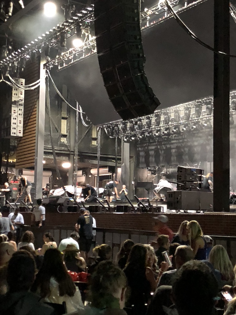
Highlights include Malco Olive Branch Cinema, BankPlus Amphitheater at Snowden Grove, Miller Plantation House and Snowden Grove Park.
August is the warmest month, with average highs of 92°F; January lows average 31°F.
Weather in Olive Branch
Forecast from the National Weather Service. Full forecast
About Olive Branch
Olive Branch is a city located in DeSoto County, Mississippi, United States. With a population of 39,711 at the 2020 census, it is the sixth most populous city in Mississippi. A suburb of Memphis, Olive Branch is part of the Memphis Metropolitan Statistical Area, a region that consists of three counties in southwest Tennessee, five counties in northwest Mississippi, and one county in eastern Arkansas. Along with other rapidly growing places in DeSoto County, Olive Branch attributes most of its growth and development to urban sprawl and flight radiating out from Memphis.
From the Wikipedia article Olive Branch, Mississippi (this version), under CC BY-SA 4.0.
Things to do3

BankPlus Amphitheater at Snowden Grove
Cinema and theater · 5.3 mi
Open-air concert venue in Southaven, Mississippi
BankPlus Amptheater at Snowden Grove
Cinema and theater · 5.3 mi
6285 Snowden Lane, Southaven
Museums and landmarks1

Miller Plantation House
Monument and historic site · National Register of Historic Places · 4.1 mi
Plantation house in DeSoto County, Mississippi
Parks, trails and playgrounds21


Cherokee Valley Golf Club
Golf course · 0.8 mi
6635 Crumpler Boulevard, Olive Branch
9 more on the map.
Restaurants and cafes62


Urban Japanese
Restaurant · Asian, Japanese · 3.2 mi
5128 Goodman Road
Mo-Fr 11:00-14:30, 17:00-21:30; Sa 12:00-22:00; Su 12:00-21:00
Viejo Vallarta Cocina & Barra
Restaurant · Mexican · 2.8 mi
7164 Hacks Cross Road, Olive Branch
Mo-Th,Su 11:00-21:30; Fr-Sa 11:00-22:30

Suga Mama Snoballs LLC
Ice cream · 4.5 mi
7041 E Shelby Dr, #117, Memphis
Tu-Sa 12:00-20:00, Su 12:00-19:00

Rancho Grande Mexican Restaurant
Restaurant · Mexican · 5.4 mi
6714 Getwell Road, Southaven
50 more on the map.
History
Olive Branch, originally named Watson's Crossroad, was established in 1846 near Chickasaw Indian Trails and incorporated in 1873.
From the History section of Olive Branch, Mississippi on Wikipedia, under CC BY-SA 4.0.
Where to stay10
Best Western Motel
Motel and hotel · 3.1 mi
10915 Business Center Drive, Olive Branch
Churches and places of worship71
Mineral Wells United Methodist Church
Church · Methodist · 5.9 mi
5400 Center Hill Road, Olive Branch
Queen of Peace Catholic Church
Church · Roman Catholic · 2.0 mi
8455 Germantown Road, Olive Branch
Broadway Baptist Church
Church · Southern Baptist · 5.4 mi
7400 Getwell Road, Southaven
Center Hill Baptist Church
Church · Baptist · 6.0 mi
8787 Center Hill Road, Olive Branch
First Church of Our Lord Jesus Christ
Church · Pentecostal · 4.5 mi
4753 South Germantown Road, Memphis
Shopping8
Gas and EV charging39
Schools, colleges and libraries57
East Shelby Branch Public Library
Library · 4.6 mi
7200 East Shelby Drive, Memphis
Center Hill Elementary School
School · 5.7 mi
13662 Center Hill Road, Olive Branch
Healthcare9
Southern VIP & Foot Rescue Surgery Center, Olive Branch, MS
Clinic and pharmacy · 2.5 mi
8990 Germantown Road, Olive Branch
Map of Olive Branch
250 places. The map loads OpenStreetMap tiles when you open it.
Climate by month
Monthly table
| Month | High | Low | Rain | Snow |
|---|---|---|---|---|
| Jan | 50°F | 31°F | 4.3 in | 0.7 in |
| Feb | 55°F | 34°F | 5.1 in | 0.6 in |
| Mar | 64°F | 41°F | 6.0 in | 0.2 in |
| Apr | 73°F | 50°F | 6.0 in | 0.0 in |
| May | 82°F | 60°F | 5.5 in | 0.0 in |
| Jun | 89°F | 68°F | 4.9 in | 0.0 in |
| Jul | 91°F | 72°F | 4.8 in | 0.0 in |
| Aug | 92°F | 70°F | 3.6 in | 0.0 in |
| Sep | 85°F | 63°F | 3.9 in | 0.0 in |
| Oct | 75°F | 50°F | 4.4 in | 0.0 in |
| Nov | 63°F | 40°F | 4.6 in | 0.0 in |
| Dec | 53°F | 34°F | 6.0 in | 0.0 in |
U.S. Climate Normals 1991-2020 for Olive Branch (1 mi away), NOAA NCEI.
People and cost of living
American Community Survey 5-year estimates, 2020-2024, U.S. Census Bureau. Estimates have margins of error, larger for small towns.
Disaster history
DeSoto County has had 13 federal disaster declarations since 2000, most often for hurricanes.
- 2026-02-06: Severe Winter Storm (Winter Storm)
- 2026-01-24: Severe Winter Storm (Winter Storm)
- 2021-10-22: Hurricane Ida (Hurricane)
- 2021-08-28: Hurricane Ida (Hurricane)
- 2020-04-05: Covid-19 Pandemic (Biological)
- 2020-03-13: Covid-19 (Biological)
OpenFEMA disaster declarations summaries.
Getting there and nearby towns
Olive Branch Airport (OLV) is the nearest airport with scheduled flights listed in OpenStreetMap, 4 miles away.
- Bridgetown 6 mi southwest, about 9 min by car
- Southaven 8 mi west, about 12 min by car
- Germantown 9 mi north, about 15 min by car
- Collierville 10 mi northeast, about 17 min by car
- Hernando 11 mi southwest, about 18 min by car
- Horn Lake 12 mi west, about 19 min by car
- Memphis 13 mi northwest, about 21 min by car
- West Memphis 24 mi northwest, about 39 min by car
- Marion 27 mi northwest, about 43 min by car
- Forrest City 54 mi west, about 1 h 30 min by car
Drive times are estimates from straight-line distance, not routes.
Local news
Headlines from INDB, the NEMICO news database.
Reviews, tips and questions
Loading what members have shared...
Sources and licences
- NCES EDGE (Public domain): public schools
- NOAA NCEI U.S. Climate Normals 1991-2020 (Public domain): climate by month
- OpenFEMA (Public domain): disaster declarations
- OpenStreetMap contributors (ODbL 1.0): places, airports, map data
- U.S. Census Bureau (Public domain): population, income, housing, education, commute
- Wikidata (CC0 1.0): elevation, founding date, time zone, website, landmarks and historic places
- Wikimedia Commons (see each image): photos
- Wikipedia (CC BY-SA 4.0): overview and history text
Photo credits
- Olive Branch MS 060 Historic Downtown, Thomas R Machnitzki ([email protected]), CC BY 3.0
- BankPlus Amphitheater 2019, ChasetheG, CC BY-SA 4.0
Page built October 30, 2026. Spotted a mistake? Tell us or suggest a place.