


Orchard Homes, Montana
Orchard Homes is a community of 5,588 people in Missoula County, Montana.
Why visit Orchard Homes
Townapedia lists 39 museums and landmarks, 22 parks and trails, 36 places to eat, 5 places to stay and 11 attractions in and around town.
Highlights include Wilma Theater, University of Montana, Apartment Building at 116 Spruce Street and Atlantic Hotel.
July is the warmest month, with average highs of 85°F; December lows average 18°F, and about 43 inches of snow fall in a normal year.
Weather in Orchard Homes
Forecast from the National Weather Service. Full forecast
About Orchard Homes
Orchard Homes is a census-designated place (CDP) in Missoula County, Montana, United States. It is part of the Missoula metropolitan area. The population was 5,377 at the 2020 census.
From the Wikipedia article Orchard Homes, Montana (this version), under CC BY-SA 4.0.
Things to do11

Wilma Theater
Cinema and theater · National Register of Historic Places · 3.7 mi
Music venue and movie theater in Missoula, Montana, United States

University of Montana
School · 4.0 mi
Public research university located in Missoula, Montana



Museums and landmarks39

Apartment Building at 116 Spruce Street
Monument and historic site · National Register of Historic Places · 3.9 mi
United States historic place

Atlantic Hotel
Monument and historic site · National Register of Historic Places · 4.0 mi
Retail, Hotel in Missoula, Montana

Bellows Residence
Monument and historic site · National Register of Historic Places · 3.5 mi
Historic house in Montana, United States

Belmont Hotel
Monument and historic site · National Register of Historic Places · 3.9 mi
Historic hotel in Missoula, Montana, United States
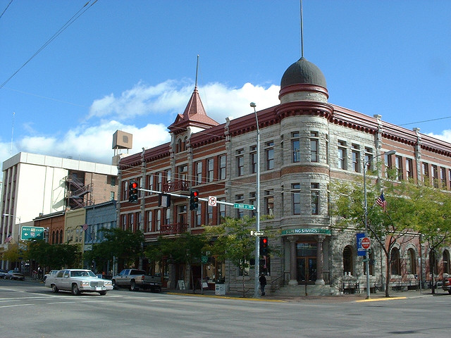
Bluebird Building
Monument and historic site · National Register of Historic Places · 3.8 mi
Historic building in Missoula, Montana, United States

Campus of the University of Montana
Monument and historic site · National Register of Historic Places · 4.0 mi
College in Montana, U.S.

Florence Hotel
Monument and historic site · National Register of Historic Places · 3.7 mi
Listed on the National Register of Historic Places in Missoula County, Montana

Forkenbrock Funeral Home
Monument and historic site · National Register of Historic Places · 4.0 mi
Commercial building in Missoula, Montana

Fort Missoula
Monument and historic site · National Register of Historic Places · 1.0 mi

Fred T. Sterling House
Monument and historic site · National Register of Historic Places · 3.6 mi
Historic house in Montana, United States
Gleim Building
Monument and historic site · National Register of Historic Places · 3.6 mi
Building in Missoula, Montana, US


Gleim Building II
Monument and historic site · National Register of Historic Places · 3.6 mi
Commercial building in Missoula, Montana, United States
27 more on the map.
Parks, trails and playgrounds22


Montana Rail Link Park
Park · 2.1 mi
Dog park, community gardens, playground, walking paths


10 more on the map.
Restaurants and cafes36



Mustard Seed
Restaurant · Asian · 2.2 mi
2901 Brooks Street, Missoula
Mo-Su 11:00-21:00
24 more on the map.
Where to stay5
Churches and places of worship22
St. Francis Xavier Church
Church · National Register of Historic Places · 3.7 mi
Christ Church Missoula
Church · Reformed · 0.9 mi
3020 South Avenue West, Missoula
Elevate Church
Church · Nondenominational · 2.2 mi
4907 Blue Mountain Road, Missoula
Kingdom Hall of Jehovah's Witnesses
Church · Jehovahs Witness · 1.5 mi
1115 South Reserve Street
Living Savior Lutheran Church
Church · Lutheran · 2.2 mi
4616 Gharrett Street, Missoula
The Church of Jesus Christ of Latter-day Saints
Church · Mormon · 0.8 mi
3026 South Avenue West, Missoula
Shopping18
Gas and EV charging7
Schools, colleges and libraries33
Healthcare4
Map of Orchard Homes
197 places. The map loads OpenStreetMap tiles when you open it.
Climate by month
Monthly table
| Month | High | Low | Rain | Snow |
|---|---|---|---|---|
| Jan | 32°F | 18°F | 1.0 in | 9.9 in |
| Feb | 37°F | 21°F | 0.9 in | 8.5 in |
| Mar | 48°F | 27°F | 0.9 in | 5.0 in |
| Apr | 56°F | 32°F | 1.4 in | 1.3 in |
| May | 66°F | 40°F | 1.8 in | 0.3 in |
| Jun | 73°F | 46°F | 2.1 in | 0.0 in |
| Jul | 85°F | 52°F | 0.8 in | 0.0 in |
| Aug | 84°F | 50°F | 0.8 in | 0.0 in |
| Sep | 73°F | 42°F | 1.0 in | 0.1 in |
| Oct | 56°F | 32°F | 1.2 in | 0.9 in |
| Nov | 40°F | 25°F | 1.2 in | 5.4 in |
| Dec | 31°F | 18°F | 1.1 in | 11.6 in |
U.S. Climate Normals 1991-2020 for Missoula Intl Ap 72773 (5 mi away), NOAA NCEI.
People and cost of living
American Community Survey 5-year estimates, 2020-2024, U.S. Census Bureau. Estimates have margins of error, larger for small towns.
Disaster history
Missoula County has had 16 federal disaster declarations since 2000, most often for fires.
- 2026-04-07: Severe Winter Storm And Straight-Line Winds (Straight-Line Winds)
- 2024-08-23: Straight-Line Winds (Straight-Line Winds)
- 2020-03-31: Covid-19 Pandemic (Biological)
- 2020-03-13: Covid-19 (Biological)
- 2018-10-31: Flooding (Flood)
- 2017-09-09: Rice Ridge Fire (Fire)
OpenFEMA disaster declarations summaries.
Getting there and nearby towns
Missoula International Airport (MSO) is the nearest airport with scheduled flights listed in OpenStreetMap, 4 miles away.
- Missoula 2 mi northeast, about 4 min by car
- Lolo 6 mi south, about 10 min by car
- East Missoula 6 mi east, about 10 min by car
- Wye 7 mi northwest, about 12 min by car
- Bonner-West Riverside 9 mi east, about 14 min by car
- Piltzville 10 mi east, about 17 min by car
- Carlton 11 mi south, about 18 min by car
- Frenchtown 15 mi northwest, about 23 min by car
- Corvallis 37 mi south, about 1 h by car
- Hamilton 42 mi south, about 1 h by car
Drive times are estimates from straight-line distance, not routes.
Local news
Headlines from INDB, the NEMICO news database.
Reviews, tips and questions
Loading what members have shared...
Sources and licences
- NCES EDGE (Public domain): public schools
- NOAA NCEI U.S. Climate Normals 1991-2020 (Public domain): climate by month
- OpenFEMA (Public domain): disaster declarations
- OpenStreetMap contributors (ODbL 1.0): places, airports, map data
- U.S. Census Bureau (Public domain): population, income, housing, education, commute
- Wikidata (CC0 1.0): elevation, founding date, time zone, website, landmarks and historic places
- Wikimedia Commons (see each image): photos
- Wikipedia (CC BY-SA 4.0): overview and history text
Photo credits
- Missoula, Montana - Wilma Theater, Publichall, CC BY-SA 3.0
- Zip Auto (2012) - Missoula County, Montana, Robstutz, CC BY-SA 3.0
- Missoula, Montana - Atlantic Hotel, Publichall, CC BY-SA 3.0
- Gleim Building, Rklawton, CC BY 3.0
- Bellows House Missoula, Montana, Joseph Thiebes, CC BY-SA 3.0
- The Prescott House - Front view - University of Montana, Djembayz, CC BY-SA 4.0
- Forkenbrock Funeral Home2 NRHP 84000570 Missoula County, MT, Jon Roanhaus, CC BY-SA 4.0
- Milwaukee Depot (2012) - Missoula County, Montana, Robstutz, CC BY-SA 3.0
- John M. Keith House, Joseph Thiebes, CC BY-SA 3.0
- Fred T. Sterling House, Joseph Thiebes, CC BY-SA 3.0
- Florence Hotel, Missoula, MT, Keenan News Agency, Public domain
- Missoula county courthouse, Mfield , Matthew Field, http://www.photography.mattfield.com, CC BY-SA 3.0
- Hammond Arcade NRHP 90000646 Missoula County, MT, Jon Roanhaus, CC BY-SA 4.0
- Missoula, MT — St. Francis Xavier Church (2021-08-08), 01, Steven Pavlov, CC BY-SA 4.0
- Northern Pacific Railroad Depot (2012) - Missoula County, Montana, Robstutz, CC BY-SA 3.0
- Higgins Block - Missoula, prizrak2084, CC BY 2.0
- Gleim 2 Building in Missoula, Montana, Henry Mulligan, CC BY 4.0
- 1982-07-06 MO07-02-ps, Rainer Halama, CC BY-SA 3.0
- Apartment building at 116 West Spruce St., Missoula, Montana, Djembayz, CC BY-SA 3.0
- Palace Hotel, Broadway Street and Ryman Street, Missoula, MT, w_lemay, CC BY-SA 2.0
- Missoula, Montana - Masonic Temple, Publichall, CC BY-SA 3.0
- Missoula, Montana - Belmont Hotel, Publichall, CC BY-SA 3.0
- Hellgate Lodge 383 BPOE building - Missoula, Montana, Djembayz, CC BY-SA 4.0
- St. Patrick's House - Missoula Montana - Jan 3 2014, Djembayz, CC BY-SA 3.0
- Montana Museum of Art & Culture, DocFreeman24, CC BY-SA 4.0
- Missoula, MT — University of Montana (2021-08-08), 01, Steven Pavlov, CC BY-SA 4.0
- MissoulaMT OldTargetRangeSchool, Magicpiano, CC BY-SA 4.0
- Missoula (MT, USA), Fort Missoula, Chevrolet Business Coupe -- 2022 -- 2378, Dietmar Rabich, CC BY-SA 4.0
- Missoula (MT, USA), Fort Missoula, Historical Museum, Train -- 2022 -- 2372, Dietmar Rabich, CC BY-SA 4.0
- Missoula (MT, USA), Fort Missoula, Historical Museum, Willamette Locomotive No 7 -- 2022 -- 2376, Dietmar Rabich, CC BY-SA 4.0
- Missoula (MT, USA), Fort Missoula, Historical Museum, Willamette Locomotive No 7 -- 2022 -- 2374, Dietmar Rabich, CC BY-SA 4.0
- Missoula (MT, USA), Fort Missoula, Historical Museum, Willamette Locomotive No 7 -- 2022 -- 2373, Dietmar Rabich, CC BY-SA 4.0
- Missoula (MT, USA), Fort Missoula, Historical Museum, Forestry Area Sawmill -- 2022 -- 2368, Dietmar Rabich, CC BY-SA 4.0
- Missoula (MT, USA), Fort Missoula, Historical Museum, Willamette Locomotive No 7 -- 2022 -- 2358, Dietmar Rabich, CC BY-SA 4.0
- Missoula (MT, USA), Fort Missoula, Historical Museum, Forestry Area Sawmill -- 2022 -- 2369, Dietmar Rabich, CC BY-SA 4.0
- Missoula (MT, USA), Fort Missoula, Historical Museum, Willamette Locomotive No 7 -- 2022 -- 2362, Dietmar Rabich, CC BY-SA 4.0
- Missoula (MT, USA), Fort Missoula, Historical Museum, Forestry Area Sawmill -- 2022 -- 2366, Dietmar Rabich, CC BY-SA 4.0
- Missoula (MT, USA), Fort Missoula, Historical Museum, Train -- 2022 -- 2365, Dietmar Rabich, CC BY-SA 4.0
- Missoula (MT, USA), Fort Missoula, Historical Museum, Willamette Locomotive No 7 -- 2022 -- 2361, Dietmar Rabich, CC BY-SA 4.0
- Missoula (MT, USA), Fort Missoula, Historical Museum, Willamette Locomotive No 7 -- 2022 -- 2370, Dietmar Rabich, CC BY-SA 4.0


Page built October 30, 2026. Spotted a mistake? Tell us or suggest a place.