


Orono, Minnesota
Orono is a city of 8,195 people in Hennepin County, Minnesota, founded in 1889.
Why visit Orono
Townapedia lists 12 museums and landmarks, 68 parks and trails, 15 places to eat, 4 places to stay and 3 attractions in and around town.
Highlights include Big Island Amusement Park, Excelsior Amusement Park, Excelsior Public School and Great Northern Depot.
July is the warmest month, with average highs of 81°F; January lows average 6°F, and about 55 inches of snow fall in a normal year.
Weather in Orono
Forecast from the National Weather Service. Full forecast
About Orono
Orono is a city in Hennepin County, Minnesota, United States. It is a suburb of Minneapolis about 16 miles (26 km) west of Lake Minnetonka's north shore. The population was 8,315 at the 2020 census.
From the Wikipedia article Orono, Minnesota (this version), under CC BY-SA 4.0.
Things to do3
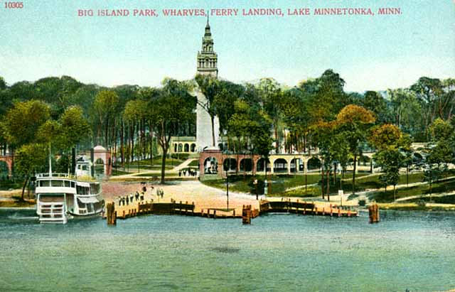
Big Island Amusement Park
Monument and historic site · 2.5 mi
Former American amusement park

Excelsior Amusement Park
Monument and historic site · 4.2 mi
Located on Lake Minnetonka in the town of Excelsior, Minnesota

Old Log Theater
Cinema and theater · 3.8 mi
Theater in Excelsior, Minnesota, United States
Museums and landmarks12

Excelsior Public School
Monument and historic site · National Register of Historic Places · 4.3 mi
School building in Excelsior, United States of America

Great Northern Depot
Monument and historic site · National Register of Historic Places · 3.5 mi
Railway station in Wayzata, Minnesota, United States

Minnehaha
Monument and historic site · National Register of Historic Places · 3.6 mi
US historic restored ship

Noerenberg Estate Barn
Monument and historic site · National Register of Historic Places · 0.4 mi
Historic barn in Orono, Minnesota, United States

Peter Gideon Farmhouse
Monument and historic site · National Register of Historic Places · 3.9 mi
Farmhouse in Minnesota, listed on the National Register of Historic Places
Thompson Summer House
Monument and historic site · National Register of Historic Places · 1.6 mi
Minnetonka Beach, Minnesota


Wyer House
Monument and historic site · National Register of Historic Places · 4.3 mi
Historic house in Minnesota, United States

Minnetonka Center for the Arts
Museum · 0.6 mi
2240 North Shore Drive, Orono
Mo,We,Sa 09:00-16:00, Tu,Th 09:00-21:00, Fr 09:00-13:00, Su closed

Parks, trails and playgrounds68



56 more on the map.
Restaurants and cafes15

Primo Plates and Pours
Restaurant · Italian · 1.9 mi
1935 Wayzata Boulevard, Long Lake
Su-Tu 17:00-20:00; Fr-Sa 17:00-21:00


Caribou Coffee
Cafe · Coffee Shop · 1.9 mi
2073 Wayzata Boulevard, Long Lake
Mo-Fr 05:30-21:00; Sa-Su 06:00-21:00
3 more on the map.
History
Orono was originally part of Excelsior Township. In 1868, it became part of Medina Township. Residents received permission from Hennepin County to form the independent town of Orono in 1889. It was incorporated as a city in 1955.
Orono is named after Orono, Maine, the hometown of early resident George A. Brackett.
On November 21, 2023, a Hennepin County Court found Orono in contempt for violating an injunctive relief order designed to safeguard the Long Lake Fire Department, its longstanding fire service provider. The court issued the order after Orono hired the Long Lake Fire Chief, attempted to take control of Long Lake Station 2, purchased a ladder truck Long Lake was considering, and asked the state legislator to forcibly transfer Long Lake's pensions to Orono to build its own fire department, while Long Lake remains contracted to serve Orono, Minnetonka Beach, and Medina. The contempt order was likely the first ever issued to a Minnesota municipality and resulted from the city willfully disobeying the provisions of the injunction prohibiting the recruitment of Long Lake firefighters and the use of Long Lake Station 2. The court also found that Mayor Dennis Walsh and Fire Chief James Van Eyll colluded to intimidate a Long Lake firefighter in violation of the order and fined the city for its violations.
From the History section of Orono, Minnesota on Wikipedia, under CC BY-SA 4.0.
Where to stay4
Churches and places of worship4
Saint Martin's by the Lake Episcopal Church
Church · Episcopal · 1.5 mi
2801 Westwood Road, Minnetonka Beach
Shopping3
Gas and EV charging5
Schools, colleges and libraries44
277 Westonka Area Learning Academy
School · 4.0 mi
5901 Sunnyfield Rd E, Minnetrista
Healthcare1
Spring Park Pharmacy
Clinic and pharmacy · 3.2 mi
4689 Shoreline Drive, Spring Park
Map of Orono
159 places. The map loads OpenStreetMap tiles when you open it.
Climate by month
Monthly table
| Month | High | Low | Rain | Snow |
|---|---|---|---|---|
| Jan | 22°F | 6°F | 0.9 in | 10.0 in |
| Feb | 27°F | 9°F | 0.9 in | 11.2 in |
| Mar | 40°F | 22°F | 1.6 in | 9.1 in |
| Apr | 55°F | 35°F | 3.2 in | 5.4 in |
| May | 68°F | 47°F | 4.4 in | 0.0 in |
| Jun | 77°F | 58°F | 4.4 in | 0.0 in |
| Jul | 81°F | 62°F | 3.9 in | 0.0 in |
| Aug | 79°F | 60°F | 4.8 in | 0.0 in |
| Sep | 71°F | 51°F | 3.3 in | 0.0 in |
| Oct | 57°F | 38°F | 2.7 in | 0.6 in |
| Nov | 41°F | 25°F | 1.7 in | 5.1 in |
| Dec | 27°F | 12°F | 1.2 in | 13.3 in |
U.S. Climate Normals 1991-2020 for Chanhassen Wsfo (8 mi away), NOAA NCEI.
People and cost of living
American Community Survey 5-year estimates, 2020-2024, U.S. Census Bureau. Estimates have margins of error, larger for small towns.
Disaster history
Hennepin County has had 10 federal disaster declarations since 2000, most often for floods.
- 2020-04-07: Covid-19 Pandemic (Biological)
- 2020-03-13: Covid-19 (Biological)
- 2016-11-02: Severe Storms And Flooding (Flood)
- 2014-07-21: Severe Storms, Straight-Line Winds, Flooding, Landslides, And Mudslides (Flood)
- 2013-07-25: Severe Storms, Straight-Line Winds, And Flooding (Severe Storm)
- 2011-06-07: Severe Storms And Tornadoes (Severe Storm)
OpenFEMA disaster declarations summaries.
Getting there and nearby towns
Flying Cloud Airport (FCM) is the nearest airport with scheduled flights listed in OpenStreetMap, 11 miles away.
- Long Lake 2 mi northeast, about 3 min by car
- Deephaven 3 mi southeast, about 6 min by car
- Mound 4 mi southwest, about 6 min by car
- Excelsior 4 mi south, about 7 min by car
- Medina 5 mi north, about 9 min by car
- Maple Plain 5 mi northwest, about 8 min by car
- Minnetrista 6 mi west, about 10 min by car
- Minnetonka 7 mi east, about 11 min by car
- Plymouth 7 mi northeast, about 12 min by car
- Victoria 7 mi southwest, about 12 min by car
Drive times are estimates from straight-line distance, not routes.
Local news
Headlines from INDB, the NEMICO news database.
Reviews, tips and questions
Loading what members have shared...
Sources and licences
- NCES EDGE (Public domain): public schools
- NOAA NCEI U.S. Climate Normals 1991-2020 (Public domain): climate by month
- OpenFEMA (Public domain): disaster declarations
- OpenStreetMap contributors (ODbL 1.0): places, airports, map data
- U.S. Census Bureau (Public domain): population, income, housing, education, commute
- Wikidata (CC0 1.0): elevation, founding date, time zone, website, landmarks and historic places
- Wikimedia Commons (see each image): photos
- Wikipedia (CC BY-SA 4.0): overview and history text
Photo credits
- Narrows bridge Cr 19, TheRoadDudeMN, CC BY-SA 4.0
- Steamboat Minnehaha in dry dock, Aaron Person, CC BY-SA 4.0
- Excelsior School 2, Elkman, CC BY-SA 4.0
- Thompson Summer House, McGhiever, CC BY-SA 4.0
- Gideon Farm 03, Elkman, CC BY-SA 4.0
- Allemarinda and James Wyer House, McGhiever, CC BY-SA 4.0
- Noerenberg Estate Barn, McGhiever, CC BY-SA 4.0
- Wayzata Depot 7, Elkman, CC BY-SA 4.0
- Excelsior Amusement Park (Minnesota), Unknown author Unknown author, Public domain
- Big Island Park, Unknown author Unknown author, Public domain
Page built October 30, 2026. Spotted a mistake? Tell us or suggest a place.