


Plymouth, Minnesota
Plymouth is a city of 79,220 people in Hennepin County, Minnesota, founded in 1852.
Why visit Plymouth
Townapedia lists 14 museums and landmarks, 148 parks and trails, 159 places to eat, 14 places to stay and 3 attractions in and around town.
Highlights include Emagine Willow Creek, New Hope Cinema Grill, Charles H. Burwell House and Great Northern Depot.
July is the warmest month, with average highs of 82°F; January lows average 7°F, and about 54 inches of snow fall in a normal year.
Weather in Plymouth
Forecast from the National Weather Service. Full forecast
About Plymouth
Plymouth is a city in Hennepin County in the U.S. state of Minnesota. A suburb in the Minneapolis–Saint Paul metropolitan area, the city is about 10 miles (16 km) west of downtown Minneapolis. The population was 81,026 at the 2020 census, making it Minnesota's 7th-largest city.
From the Wikipedia article Plymouth, Minnesota (this version), under CC BY-SA 4.0.
Things to do3

New Hope Cinema Grill
Cinema and theater · 4.1 mi
2749 Winnetka Avenue North, New Hope
Museums and landmarks14

Charles H. Burwell House
Monument and historic site · National Register of Historic Places · 5.6 mi
Historic house in Minnesota, United States

Great Northern Depot
Monument and historic site · National Register of Historic Places · 4.6 mi
Railway station in Wayzata, Minnesota, United States

Minnehaha
Monument and historic site · National Register of Historic Places · 4.5 mi
US historic restored ship
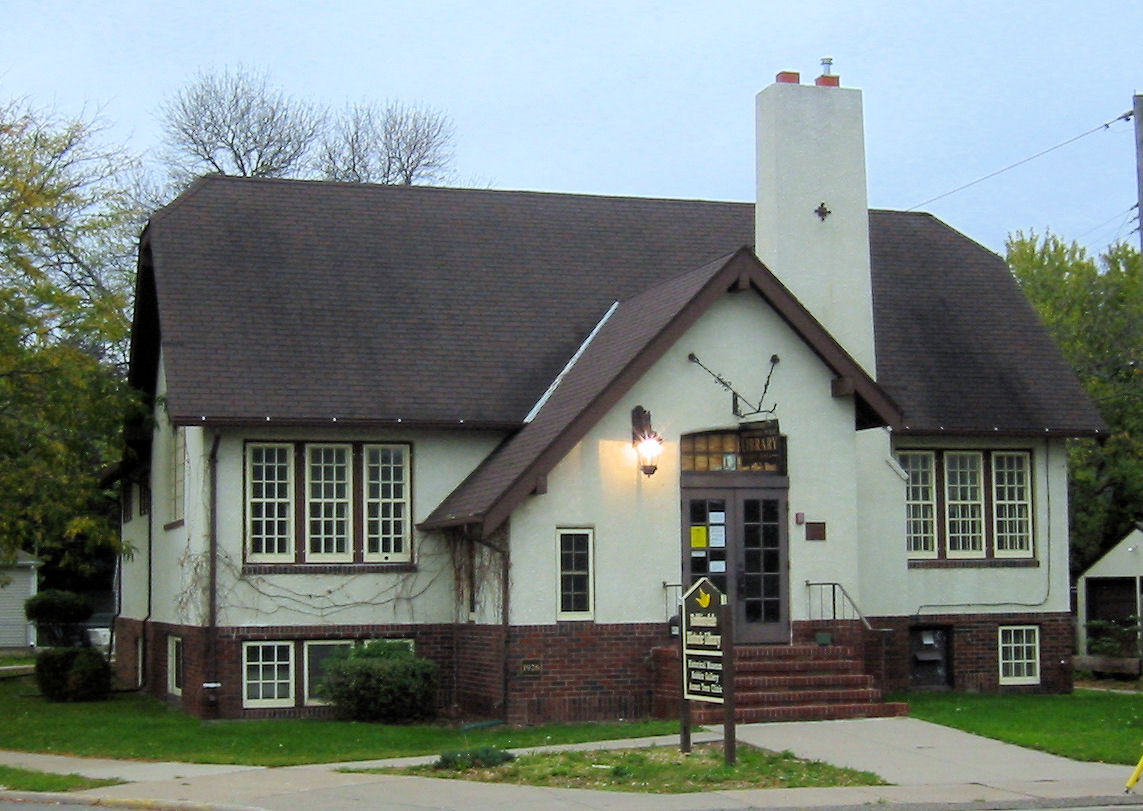


Robbinsdale Library
Monument and historic site · National Register of Historic Places · 5.9 mi
Branch library of the Hennepin County Library system in Robbinsdale, Minnesota

Golden Valley History Museum
Museum · 5.3 mi
Museum in Golden Valley, Minnesota

2 more on the map.
Parks, trails and playgrounds148

Graeser Park
Park · 6.0 mi
Park in Robbinsdale, Hennepin County, United States of America


Maple Grove Forest Preservation Area B
Hiking and trails · 3.8 mi
Mo-Su 06:00-23:00
136 more on the map.
Restaurants and cafes159

Bacio
Restaurant · Italian · 3.8 mi
1571 Plymouth Road
Tu-Fr 11:00-22:00; Sa 10:00-22:00; Su 10:00-21:00; Mo 11:00-21:00

Blackwater Cafe & Coffee
Cafe · Coffee Shop · 3.9 mi
11210 Wayzata Boulevard, Minnetonka
Mo-Fr 06:30-19:00; Sa-Su 07:00-17:00
Dave’s Hot Chicken
Restaurant · Chicken · 3.9 mi
1805 Plymouth Road
Su-Th 10:30-23:00; Fr-Sa 10:30-00:00

Fork’d
Diner · American · 3.8 mi
1641 Plymouth Road
Tu-Fr 11:00-22:00; Mo 11:00-21:00; Sa 10:00-22:00; Su 10:00-21:00
Ham’s Sandwich Shop
Restaurant · Sandwich · 3.4 mi
14200 Wayzata Boulevard
Mo-Fr 08:00-19:00; Sa 10:00-15:00
Poke & Song Tea
Restaurant · Poke, Tea, Milk Tea · 1.1 mi
3505 Vicksburg Lane North, Plymouth
Mo-Su 11:00-20:00
147 more on the map.
History
Plymouth's history can be traced to the pre-Columbian period. The original inhabitants were the Dakota. Their encampment was at the north end of Medicine Lake. The name Medicine Lake is derived from the Dakota word Mdewakanton, meaning "Lake of the Spirit." The Dakota named the lake after a warrior who overturned his canoe and his body was never recovered.
Antoine LeCounte, a guide and explorer, was the first settler in this area. He arrived in 1848, but did not settle until 1852. He carried mail from the Red River of the North to points south, trading goods to Native Americans for horses on the way. LeCounte built the first cabin at what is now East Medicine Lake Boulevard at 29th Avenue North.
Plymouth's beginning as a town occurred in 1855 on the northwest shores of what is now known as Parkers Lake. A gristmill and other structures were built in the area. In the spring of 1857, when Parkers Lake flooded, the mill was taken down and moved to Wayzata.
As new settlers arrived in the area, they organized. The Hennepin County Board of Commissioners named the new settlement Plymouth. On April 19, 1858, a group of townspeople met at Francis Day's home to open elections for town offices. On May 11, 1858, the group voted to change the town's name to Medicine Lake. This was used once at the town meeting, but for reasons not recorded, it was never used again.
From the History section of Plymouth, Minnesota on Wikipedia, under CC BY-SA 4.0.
Where to stay14
Extended Stay America - Minneapolis - Maple Grove
Motel and hotel · 3.4 mi
12970 63rd Avenue North, Maple Grove
Home2 Suites by Hilton Plymouth Minneapolis
Motel and hotel · 0.6 mi
2990 Harbor Lane North, Plymouth
Sheraton Minneapolis West Hotel
Motel and hotel · 4.2 mi
12201 Ridgedale Drive, Minnetonka
Churches and places of worship28
Mount Olivet Lutheran Church of Plymouth
Church · Lutheran · 1.4 mi
12235 Old Rockford Road, Plymouth
Saint Joseph the Worker Catholic Church
Church · Roman Catholic · 4.6 mi
7180 Hemlock Lane North, Maple Grove
Shepherd of the Grove Lutheran Church LCMS
Church · Lutheran · 4.1 mi
11875 West Eagle Lake Drive, Maple Grove
The Church of Jesus Christ of Latter-day Saints
Church · Mormon · 2.9 mi
330 Vicksburg Lane North, Plymouth
Shopping39
Gas and EV charging29
Schools, colleges and libraries72
Healthcare12
North Memorial Clinic - New Hope
Clinic and pharmacy · 4.0 mi
8100 42nd Avenue North, New Hope
Park Nicollet Clinic Minnetonka Carlson Parkway
Clinic and pharmacy · 3.4 mi
15111 Twelve Oaks Center Drive, Wayzata
Map of Plymouth
250 places. The map loads OpenStreetMap tiles when you open it.
Climate by month
Monthly table
| Month | High | Low | Rain | Snow |
|---|---|---|---|---|
| Jan | 24°F | 7°F | 0.9 in | 10.1 in |
| Feb | 29°F | 11°F | 1.0 in | 10.1 in |
| Mar | 42°F | 23°F | 1.9 in | 9.0 in |
| Apr | 57°F | 35°F | 3.3 in | 5.1 in |
| May | 69°F | 48°F | 4.5 in | 0.0 in |
| Jun | 78°F | 58°F | 4.6 in | 0.0 in |
| Jul | 82°F | 63°F | 4.5 in | 0.0 in |
| Aug | 80°F | 61°F | 4.2 in | 0.0 in |
| Sep | 72°F | 52°F | 3.5 in | 0.0 in |
| Oct | 57°F | 39°F | 3.0 in | 0.8 in |
| Nov | 41°F | 26°F | 1.9 in | 6.9 in |
| Dec | 28°F | 14°F | 1.4 in | 12.3 in |
U.S. Climate Normals 1991-2020 for New Hope (4 mi away), NOAA NCEI.
People and cost of living
American Community Survey 5-year estimates, 2020-2024, U.S. Census Bureau. Estimates have margins of error, larger for small towns.
Disaster history
Hennepin County has had 10 federal disaster declarations since 2000, most often for floods.
- 2020-04-07: Covid-19 Pandemic (Biological)
- 2020-03-13: Covid-19 (Biological)
- 2016-11-02: Severe Storms And Flooding (Flood)
- 2014-07-21: Severe Storms, Straight-Line Winds, Flooding, Landslides, And Mudslides (Flood)
- 2013-07-25: Severe Storms, Straight-Line Winds, And Flooding (Severe Storm)
- 2011-06-07: Severe Storms And Tornadoes (Severe Storm)
OpenFEMA disaster declarations summaries.
Getting there and nearby towns
Crystal Airport (MIC) is the nearest airport with scheduled flights listed in OpenStreetMap, 6 miles away.
- New Hope 4 mi east, about 6 min by car
- Crystal 5 mi east, about 8 min by car
- Golden Valley 6 mi southeast, about 9 min by car
- Minnetonka 6 mi south, about 10 min by car
- Maple Grove 7 mi north, about 11 min by car
- Hopkins 7 mi southeast, about 12 min by car
- Brooklyn Center 8 mi northeast, about 12 min by car
- Brooklyn Park 8 mi northeast, about 13 min by car
- Minneapolis 10 mi southeast, about 17 min by car
- Edina 10 mi southeast, about 17 min by car
Drive times are estimates from straight-line distance, not routes.
Local news
Headlines from INDB, the NEMICO news database.
Reviews, tips and questions
Loading what members have shared...
Sources and licences
- NCES EDGE (Public domain): public schools
- NOAA NCEI U.S. Climate Normals 1991-2020 (Public domain): climate by month
- OpenFEMA (Public domain): disaster declarations
- OpenStreetMap contributors (ODbL 1.0): places, airports, map data
- U.S. Census Bureau (Public domain): population, income, housing, education, commute
- Wikidata (CC0 1.0): elevation, founding date, time zone, website, landmarks and historic places
- Wikimedia Commons (see each image): photos
- Wikipedia (CC BY-SA 4.0): overview and history text
Photo credits
- 2009-0603-07-Air-WayzataHS, Bobak Ha'Eri, CC BY 3.0
- Collection storage, Plymouth Historical Society-Plymouth, Minnesota, Heritage Preservation Department - MNHS, CC BY-SA 2.0
- Lounge, oral history area, City of Plymouth History Center, Myotus, CC BY 4.0
- City of Plymouth History Center, side, Myotus, CC BY 4.0
- Archive research area, City of Plymouth History Center, Myotus, CC BY 4.0
- Grand reopening-City of Plymouth History Center-06, Myotus, CC BY 4.0
- Archives, City of Plymouth History Center-01, Myotus, CC BY 4.0
- Archives, City of Plymouth History Center-02, Myotus, CC BY 4.0
- Scanning station, City of Plymouth History Center, Myotus, CC BY 4.0
- City of Plymouth History Center, back, Myotus, CC BY 4.0
- Grand reopening-City of Plymouth History Center-07, Myotus, CC BY 4.0
- Plymouth History Museum, Plymouth, Minnesota, Heritage Preservation Department - MNHS, CC BY-SA 2.0
- Visitors at exhibit, City of Plymouth History Center, Myotus, CC BY 4.0
- Signage, Plymouth History Museum, Plymouth, MN, Heritage Preservation Department - MNHS, CC BY-SA 2.0
- Grand reopening-City of Plymouth History Center-09, Myotus, CC BY 4.0
- City of Plymouth History Center, from park, Myotus, CC BY 4.0
- Grand reopening-City of Plymouth History Center-11, Myotus, CC BY 4.0
- Grand reopening-City of Plymouth History Center-08, Myotus, CC BY 4.0
- Plymouth Town Hall-Plymouth, Minnesota, Myotus, CC BY-SA 4.0
- Plymouth Library 2021, McGhiever, CC BY-SA 4.0
- Plymouth Library, Paul2520, CC BY-SA 4.0
- Steamboat Minnehaha in dry dock, Aaron Person, CC BY-SA 4.0
- Charles H. Burwell House, McGhiever, CC BY-SA 4.0
- Robbinsdale Library 002, Elkman, CC BY-SA 4.0
- Wayzata Depot 7, Elkman, CC BY-SA 4.0
- MacBook Air Error (23443882792), Tony Webster from Minneapolis, Minnesota, United States, CC BY-SA 2.0
- Hospital Patient Monitor (17239884329), Tony Webster from San Francisco, California, CC BY 2.0
- Nurse Call Button at Hospital (17238701230), Tony Webster from Minneapolis, Minnesota, United States, CC BY 2.0
- BIOHAZARD Sticker (17400246206), Tony Webster from Minneapolis, Minnesota, United States, CC BY 2.0
- Pull for Help Nurse Call in Hospital (16868117184), Tony Webster from Minneapolis, Minnesota, United States, CC BY 2.0
- Arthur Prince Spear - The Nymph and the Turtle (1920), Arthur Prince Spear, Public domain
- Arthur Prince Spear - In the Studio (1942), Arthur Prince Spear, Public domain
- Arthur Prince Spear - Titania (1927), Arthur Prince Spear, Public domain
- Providence Academy (Minnesota), Darth Stabro, CC BY 4.0
- Providence Academy side view, Darth Stabro, CC BY 4.0
- Providence Academy (Minnesota) (cropped), Darth Stabro, CC BY 4.0
- Providence Academy front entrance, Darth Stabro, CC BY 4.0
- The Holder of the Crystal, Pranusha U, CC BY-SA 4.0
- 9 Pin & 15 Pin D-subminiature, Unconventional2, CC0
- Wired Chouinard RURP, Unconventional2, CC0


Page built October 30, 2026. Spotted a mistake? Tell us or suggest a place.