


Palmyra, New Jersey
Palmyra is a borough of 7,485 people in Burlington County, New Jersey, founded in April 19, 1894.
Why visit Palmyra
Townapedia lists 24 museums and landmarks, 9 parks and trails, 14 places to eat and 5 attractions in and around town.
Highlights include Tacony Music Hall, Frankford Avenue Bridge, Frankford Arsenal and Alternative Middle Years at James Martin School.
July is the warmest month, with average highs of 87°F; January lows average 25°F.
Weather in Palmyra
Forecast from the National Weather Service. Full forecast
About Palmyra
Palmyra is a borough in Burlington County, in the U.S. state of New Jersey. As of the 2020 United States census, the borough's population was 7,438, an increase of 40 (+0.5%) from the 2010 census count of 7,398, which in turn reflected an increase of 307 (+4.3%) from the 7,091 counted in the 2000 census. The borough, and all of Burlington County, is a part of the Philadelphia metropolitan area.
From the Wikipedia article Palmyra, New Jersey (this version), under CC BY-SA 4.0.
Things to do5

Tacony Music Hall
Cinema and theater · National Register of Historic Places · 1.5 mi
Historic building in the Tacony section of Philadelphia, Pennsylvania

Frankford Avenue Bridge
Bridge · National Register of Historic Places · 2.9 mi
Tacony–Palmyra Bridge
Bridge · 0.8 mi
Bridge that connects from Palmyra, New Jersey to Philadelphia (Tacony), Pennsylvania
Museums and landmarks24
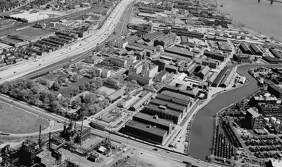
Frankford Arsenal
Monument and historic site · National Register of Historic Places · 1.7 mi
Former United States Army munitions plant

Alternative Middle Years at James Martin School
Monument and historic site · National Register of Historic Places · 3.5 mi
Public middle school in Philadelphia, Pennsylvania

Burrough-Dover House
Monument and historic site · National Register of Historic Places · 2.3 mi
Historic house in Camden County, New Jersey

Carl Mackley Houses
Monument and historic site · National Register of Historic Places · 3.4 mi
Residential building in Pennsylvania, United States of America

David Wilmot School
Monument and historic site · National Register of Historic Places · 2.5 mi
Building in Pennsylvania, United States

Ethan Allen School
Monument and historic site · National Register of Historic Places · 2.3 mi
United States historic place

Griffith Morgan House
Monument and historic site · National Register of Historic Places · 1.1 mi
Pennsauken Township, New Jersey, listed on the NRHP in Camden County

Henry Longfellow School
Monument and historic site · National Register of Historic Places · 1.9 mi
In northeast Philadelphia, Pennsylvania, NRHP-listed

John Ruan House
Monument and historic site · National Register of Historic Places · 3.0 mi
Building in Pennsylvania, United States

Philadelphia Charter School for Arts and Sciences
Monument and historic site · National Register of Historic Places · 3.1 mi
Charter school in Philadelphia, Pennsylvania

Warren G. Harding Middle School
Monument and historic site · National Register of Historic Places · 2.2 mi
Middle school in Philadelphia, Pennsylvania


William W. Axe School
Monument and historic site · National Register of Historic Places · 2.6 mi
School building in Philadelphia, United States of America
12 more on the map.
Parks, trails and playgrounds9



Restaurants and cafes14

Kaffir Thai
Restaurant · Thai · 0.8 mi
16 East Broad Street, Palmyra
Tu-Fr 11:00-15:00,16:00-22:00; Sa 16:00-22:00; Su 16:00-21:00; Mo off
Palmyra Taco House
Restaurant · Mexican · 0.7 mi
537 Cinnaminson Avenue, Palmyra
Mo-Sa 11:00-22:00; Su off

Double Nickel Brewing Company
Brewery and winery · 1.5 mi
1585 NJ 73, Pennsauken Township
Mo-Th 16:00-22:00; Fr 14:00-23:00; Sa 12:00-23:00; Su 12:00-21:00


5West Pub & Resturant
Bar and pub · 0.7 mi
5 West Broad Street, Palmyra
Su 11:00-24:00; Mo-We 15:00-21:00; Th 15:00-22:00; Fr-Sa 15:00-22:00

Domino's
Fast food · Pizza · 1.6 mi
1821 Cinnaminson Avenue, Cinnaminson
Mo-Th 10:30-24:00; Fr-Sa 10:30-01:00; Su 10:30-24:00
Dunkin' Donuts
Fast food · Donut, Coffee Shop · 1.0 mi
1041 Route 73, Pennsauken
Mo-Fr 04:30-20:00; Sa-Su 04:30-19:00
2 more on the map.
History
The area that is now Palmyra was settled in the late 17th century by Swedes, marking the northernmost border of New Sweden. A farmhouse built in 1761 by the third generation of settlers still remains as the oldest house in Palmyra. Farming was the primary use of land in Palmyra and the surrounding area until after the construction of the Camden and Amboy Railroad in 1834 with a station in the area, after which railroad workers built homes on lots they purchased along the railroad right of way. The community was originally known as Texas, but a local landowner, Isaiah Toy, a descendant of the original Swedish settlers and a stockholder in the Camden and Amboy Railroad, who wanted to have a post office established in the community, convinced the railroad to change the name of the station in 1849 to Palmyra, which came from his love of ancient history. Palmyra was the name of an ancient trading center located in central Syria. The post office was established in 1851. Palmyra, along with the city of Burlington and the townships of Bordentown, Moorestown, and Mount Holly, established its high school in the late 1890s, making it one of the oldest high schools in Burlington County and in New Jersey.
From the History section of Palmyra, New Jersey on Wikipedia, under CC BY-SA 4.0.
Churches and places of worship7
Gas and EV charging3
Schools, colleges and libraries49
Camden County Technical School-Pennsauken
School · 4.7 mi
6008 Browning Road, Pennsauken
Clara Barton Elementary School
School · 5.7 mi
223 Rhode Island Ave., Cherry Hill
Healthcare1
Map of Palmyra
112 places. The map loads OpenStreetMap tiles when you open it.
Climate by month
Monthly table
| Month | High | Low | Rain |
|---|---|---|---|
| Jan | 40°F | 25°F | 3.5 in |
| Feb | 43°F | 26°F | 2.6 in |
| Mar | 52°F | 33°F | 4.4 in |
| Apr | 64°F | 42°F | 3.9 in |
| May | 73°F | 52°F | 3.9 in |
| Jun | 82°F | 62°F | 4.6 in |
| Jul | 87°F | 68°F | 5.0 in |
| Aug | 85°F | 66°F | 4.1 in |
| Sep | 78°F | 59°F | 4.3 in |
| Oct | 66°F | 46°F | 4.1 in |
| Nov | 55°F | 36°F | 3.3 in |
| Dec | 45°F | 30°F | 4.5 in |
U.S. Climate Normals 1991-2020 for Pennsauken 1N (3 mi away), NOAA NCEI.
People and cost of living
American Community Survey 5-year estimates, 2020-2024, U.S. Census Bureau. Estimates have margins of error, larger for small towns.
Disaster history
Burlington County has had 23 federal disaster declarations since 2000, most often for hurricanes.
- 2021-09-05: Remnants Of Hurricane Ida (Hurricane)
- 2021-09-02: Remnants Of Hurricane Ida (Hurricane)
- 2020-12-11: Tropical Storm Isaias (Hurricane)
- 2020-03-25: Covid-19 Pandemic (Biological)
- 2020-03-13: Covid-19 (Biological)
- 2018-06-08: Severe Winter Storm And Snowstorm (Severe Storm)
OpenFEMA disaster declarations summaries.
Getting there and nearby towns
Northeast Philadelphia Airport (PNE) is the nearest airport with scheduled flights listed in OpenStreetMap, 6 miles away.
- Merchantville 4 mi south, about 6 min by car
- Philadelphia 5 mi west, about 8 min by car
- Cherry Hill Mall 5 mi south, about 7 min by car
- Moorestown-Lenola 5 mi southeast, about 8 min by car
- Golden Triangle 5 mi south, about 8 min by car
- Camden 6 mi southwest, about 10 min by car
- Ellisburg 6 mi south, about 10 min by car
- Collingswood 6 mi south, about 10 min by car
- Kingston Estates 6 mi south, about 10 min by car
- Westmont 7 mi south, about 11 min by car
Drive times are estimates from straight-line distance, not routes.
Local news
Headlines from INDB, the NEMICO news database.
Reviews, tips and questions
Loading what members have shared...
Sources and licences
- NCES EDGE (Public domain): public schools
- NOAA NCEI U.S. Climate Normals 1991-2020 (Public domain): climate by month
- OpenFEMA (Public domain): disaster declarations
- OpenStreetMap contributors (ODbL 1.0): places, airports, map data
- U.S. Census Bureau (Public domain): population, income, housing, education, commute
- Wikidata (CC0 1.0): elevation, founding date, time zone, website, landmarks and historic places
- Wikimedia Commons (see each image): photos
- Wikipedia (CC BY-SA 4.0): overview and history text
Photo credits
- 2018-05-23 13 50 26 View south along New Jersey State Route 73 (Palmyra Bridge Boulevard) just north of West 5th Street in Palmyra, Burlington County, New Jersey, Famartin, CC BY-SA 4.0
- 2018-05-23 13 43 00 View north along New Jersey State Route 73 (Palmyra Bridge Boulevard) just north of West 5th Street in Palmyra, Burlington County, New Jersey, Famartin, CC BY-SA 4.0
- 2020-09-07 12 40 04 View south along New Jersey State Route 73 (Palmyra Bridge Boulevard) at the exit for Burlington County Route 543 SOUTH-River Road (Camden) in Palmyra, Burlington County, New..., Famartin, CC BY-SA 4.0
- 2020-10-13 14 50 40 View south along Burlington County Route 543 (West Broad Street) at Market Street and Public Road in Palmyra, Burlington County, New Jersey, Famartin, CC BY-SA 4.0
- 2018-05-23 17 20 52 View north along Burlington County Route 543 (Broad Street) at Market Street in Palmyra, Burlington County, New Jersey, Famartin, CC BY-SA 4.0
- CR 543 sb at Public Road, Palmyra, NJ, April 2026, Mr. Matté (if there is an issue with this image, contact me using this image's Commons talk page , my Commons user talk page , or my English Wikipedia user talk page ; I'll know about it a lot faster), CC BY-SA 4.0
- Palmyra, United States (Unsplash), Ray Hennessy rayhennessy, CC0
- 2021-09-07 15 05 17 View north along New Jersey State Route 73 (Palmyra Bridge Boulevard) from the overpass for the rail line near West Broad Street in Palmyra, Burlington County, New Jersey, Famartin, CC BY-SA 4.0
- 2021-09-07 15 04 44 View south along New Jersey State Route 73 (Palmyra Bridge Boulevard) from the overpass for the rail line near West Broad Street in Palmyra, Burlington County, New Jersey, Famartin, CC BY-SA 4.0
- 2018-05-23 17 11 49 View south along Burlington County Route 543 (Public Road) between Broad Street and Spring Garden Street in Palmyra, Burlington County, New Jersey, Famartin, CC BY-SA 4.0
- Legion Field, Palmyra, NJ, Dec. 2024, Mr. Matté (if there is an issue with this image, contact me using this image's Commons talk page , my Commons user talk page , or my English Wikipedia user talk page ; I'll know about it a lot faster), CC BY-SA 4.0
- Palmyra, United States (Unsplash PBjvkCDr3aQ), Ray Hennessy rayhennessy, CC0
- 2018-05-23 17 17 47 View north along Burlington County Route 543 (Public Road) at Spring Garden Street in Palmyra, Burlington County, New Jersey, Famartin, CC BY-SA 4.0
- 2020-09-07 12 12 08 View north along New Jersey State Route 73 (Palmyra Bridge Boulevard) at the exit for Burlington County Route 543 NORTH (Riverton) in Palmyra, Burlington County, New Jersey, Famartin, CC BY-SA 4.0
- 2020-09-07 12 43 17 View south along New Jersey State Route 73 (Palmyra Bridge Boulevard) at the exit for Palmyra in Palmyra, Burlington County, New Jersey, Famartin, CC BY-SA 4.0
- 2018-05-23 17 12 53 View south along Burlington County Route 543 (New River Road) just north of New Jersey State Route 73 (Palmyra Bridge Boulevard) in Palmyra, Burlington County, New Jersey, Famartin, CC BY-SA 4.0
- 2020-10-13 11 19 47 View north along Burlington County Route 543 (River Road) at the exit for New Jersey State Route 73 NORTH (Tacony Palmyra Bridge, Philadelphia) in Palmyra, Burlington County, New..., Famartin, CC BY-SA 4.0
- 2020-10-13 14 52 47 View south along Burlington County Route 543 (River Road) at the exit for New Jersey State Route 73 SOUTH (Marlton, Shore Points) in Palmyra, Burlington County, New Jersey, Famartin, CC BY-SA 4.0
- 2021-09-07 14 57 08 View north along New Jersey State Route 73 (Palmyra Bridge Boulevard) from the overpass for Burlington County Route 543 (River Road) in Palmyra, Burlington County, New Jersey, Famartin, CC BY-SA 4.0
- 2021-09-07 14 55 15 View south along New Jersey State Route 73 (Palmyra Bridge Boulevard) from the overpass for Burlington County Route 543 (River Road) in Palmyra, Burlington County, New Jersey, Famartin, CC BY-SA 4.0
- Tacony Palmyra Bridge 20100604-jag9889, Jag9889, CC BY-SA 4.0
- 2018-05-23 17 15 32 View north along Burlington County Route 543 (New River Road) just south of New Jersey State Route 73 (Palmyra Bridge Boulevard) in Palmyra, Burlington County, New Jersey, Famartin, CC BY-SA 4.0
- 2020-09-07 12 10 01 View north along New Jersey State Route 73 (Palmyra Bridge Boulevard) at the exit for Burlington County Route 543 SOUTH-River Road (Camden) in Palmyra, Burlington County, New..., Famartin, CC BY-SA 4.0
- Burlington CR 601 nb, Palmyra, NJ (2), April 2026, Mr. Matté (if there is an issue with this image, contact me using this image's Commons talk page , my Commons user talk page , or my English Wikipedia user talk page ; I'll know about it a lot faster), CC BY-SA 4.0
- Palmyra, NJ post office, Dec. 2024, Mr. Matté (if there is an issue with this image, contact me using this image's Commons talk page , my Commons user talk page , or my English Wikipedia user talk page ; I'll know about it a lot faster), CC BY-SA 4.0
- Independence Fire Company, Palmyra, NJ, Dec. 2024, Mr. Matté (if there is an issue with this image, contact me using this image's Commons talk page , my Commons user talk page , or my English Wikipedia user talk page ; I'll know about it a lot faster), CC BY-SA 4.0
- Palmyra, NJ community center, Dec. 2024, Mr. Matté (if there is an issue with this image, contact me using this image's Commons talk page , my Commons user talk page , or my English Wikipedia user talk page ; I'll know about it a lot faster), CC BY-SA 4.0
- Palmyra, NJ borough hall (1), Dec. 2024, Mr. Matté (if there is an issue with this image, contact me using this image's Commons talk page , my Commons user talk page , or my English Wikipedia user talk page ; I'll know about it a lot faster), CC BY-SA 4.0
- FrankfordArsenal, Joseph Elliott, photographer, Public domain
- Mackley NE Philly, Smallbones, Public domain
- Phila HenryREdmondsSchool01, Davidt8, Public domain
- Wm Axe School Philly, Smallbones, Public domain
- Tacony Music Hall HABS, HABS photographer, Public domain
- Ruan House A Philly, Smallbones, Public domain
- Wilmot School Philly, Smallbones, Public domain
- E Allen School Philly, Smallbones, Public domain
- Longfellow School Philly, Smallbones, Public domain
- BURROUGH-DOVER HOUSE, PENNSAUKEN, CAMDEN COUNTY, Jerrye & Roy Klotz, MD, CC BY-SA 3.0
- Phila JamesMartinSchool01, Davidt8, Public domain
- Griffith Morgan House Interior, Paul Rudderow, CC BY-SA 3.0


Page built October 30, 2026. Spotted a mistake? Tell us or suggest a place.