
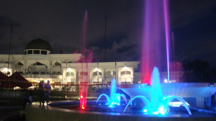


Isulan, Philippines
Isulan is a city of 101,455 people in Soccsksargen, Philippines, founded in August 30, 1957.
Why visit Isulan
Townapedia lists 4 museums and landmarks, 6 parks and trails, 55 places to eat, 9 places to stay and 1 attraction in and around town.
Highlights include Kids Paradise.
Weather in Isulan
Forecast from MET Norway (CC BY 4.0). Full forecast
About Isulan
Isulan, officially the Municipality of Isulan (Hiligaynon: Banwa sang Isulan; Maguindanaon: Inged nu Isulan, Jawi: ايڠد نو اسولن; Tagalog: Bayan ng Isulan), is a municipality and capital of the province of Sultan Kudarat, Philippines. According to the 2024 census, it has a population of 101,455 people.
From the Wikipedia article Isulan (this version), under CC BY-SA 4.0.
Travel tips from other travellers: Isulan on Wikivoyage (CC BY-SA 4.0).
Things to do1

Museums and landmarks4


Parks, trails and playgrounds6

Kids Paradise
Playground · 1.1 km
Tacurong-Isulan Highway, Isulan
Mo-Su 09:00-19:00



Restaurants and cafes55

Junjun Kambingan
Restaurant · Filipino, Goat · 10.4 km
Alunan Highway, Tacurong City
Mo-Su 08:00-18:00

Little Miss Tea
Cafe
General Siongco Street, Isulan
Mo-Su 11:00-18:00

Rogelio's Bakery Café
Bakery · 9.5 km
New Isabela Road, Tacurong City
Mo-Sa 13:00-19:00
Antonia's Resto & Catering
Restaurant · 0.6 km
Mo-Su 07:00-21:00
Goldyfood
Restaurant · 10.6 km
General Lim Street, Tacurong City
Mo-Su 08:00-05:00
Hungry Fish Seafood Grill
Restaurant · Seafood, Filipino, Fish · 8.9 km
Upper Katungal - Calean Road, Tacurong
43 more on the map.
History
The present territories of Isulan formerly belonged to the municipalities of Koronadal and Dulawan. The municipality of Koronadal was created under E.O. No. 82 dated August 8, 1947 by Pres. Manuel L. Roxas.
On March 10, 1953, the municipality of Norala was created by virtue of E.O.NO.572, whose territorial jurisdiction was taken from the municipality of Koronadal.
Datu Kudanding Camsa in the latter part of 1956 initiated the creation of another municipality to be taken from the Municipality of Norala.
On March 20, 1957, Engr. Jose M. Ancheta of the Bureau of Public Highways of Cotabato made its first endorsement to the provincial board and laid down the proposed boundaries of the new municipality.
Acting on this report, the provincial board of Cotabato thru Resolution No. 316 series of 1957, petitioned the President of the Philippines to create the proposed municipality.
Executive Order No. 266, pursuant to section 68 of the Administrative Code, issued and signed by the then President Carlos P. Garcia on August 30, 1957, creating the municipality of Isulan, whose territorial jurisdiction was taken from the municipality of Norala, South Cotabato, and Dulawan, Cotabato.
From the History section of Isulan on Wikipedia, under CC BY-SA 4.0.
Where to stay9
Churches and places of worship22
Iglesia ni Cristo
Church · Iglesia Ni Cristo · 11.1 km
Tacurong-Isulan Highway, Tacurong
Isulan Baptist Church
Church · Southern Baptist Church · 0.9 km
Municipal Road, Isulan
Isulan Baptist Convention Church
Church · Baptist · 1.1 km
Kalachuchi Street, Isulan
Kingdom Hall of Jehovah's Witnesses
Church · Jehovahs Witness · 11.1 km
Diego Silang Street, Tacurong City
Tacurong Seventh-day Adventist Church
Church · Seventh Day Adventist · 10.4 km
Ledesma Street, Tacurong City
United Methodist Church
Church · Methodist · 10.4 km
Alunan Highway, Tacurong City
Bible Baptist Church
Place of worship · 10.9 km
Tacurong-President Quirino National Highway
Shopping36
Victory Marketing
Hardware store · 11.0 km
Tacurong-President Quirino National Highway
Aseana General Merchandise
Shopping center · 10.3 km
Mabini Street, Tacurong City
DMFI Hardware and General Store
Hardware store · 10.8 km
Alunan Highway, Tacurong City
ERS General Merchandise
Hardware store · 11.3 km
Doña Alicia Street, Tacurong City
Imperial Appliance Plaza
Shopping center · 10.7 km
Tacurong-President Quirino National Highway
Gas and EV charging20
Shell
Gas station · 11.5 km
Tacurong-President Quirino National Highway, Tacurong City
Schools, colleges and libraries142
Sultan Kudarat State University
School · 10.7 km
Alunan Highway, Tacurong City
Tacurong SDA Elementary School
School · Seventh Day Adventist · 10.4 km
Ledesma Street, Tacurong City
Centerpoint College of Arts and Sciences
School · 11.0 km
Tacurong-President Quirino National Highway
Dorin Elementary School
School · 14.2 km
Isulan Junction-Ninoy Aquino Road, Bagumbayan
Healthcare25
Sultan Kudarat Provincial Hospital
Hospital · 1.6 km
Tacurong - Isulan National Highway
Cabaluna Surgical Center
Clinic and pharmacy · 10.2 km
Lapu-Lapu Street, Tacurong City
Isulan Doctor's Specialist Center
Hospital · 1.1 km
Tacurong-Isulan Highway, Isulan
Lu Clinic and Hospital
Hospital · 10.8 km
Tacurong-President Quirino National Highway
Map of Isulan
250 places. The map loads OpenStreetMap tiles when you open it.
Getting there and nearby towns
Allah Valley Airport (AAV) is the nearest airport with scheduled flights listed in OpenStreetMap, 33 km away.
- Tacurong 11 km northeast, about 11 min by car
- Esperanza 14 km northwest, about 14 min by car
- President Quirino 17 km northeast, about 17 min by car
- Buluan 24 km northeast, about 24 min by car
- Banga 30 km southeast, about 30 min by car
- Koronadal 30 km southeast, about 30 min by car
- Surallah 32 km southeast, about 32 min by car
- Lake Sebu 46 km south, about 46 min by car
- Pikit 48 km north, about 48 min by car
- Pagalungan 49 km north, about 49 min by car
Drive times are estimates from straight-line distance, not routes.
Local news
Headlines from INDB.
Reviews, tips and questions
Loading what members have shared...
Sources and licences
- GeoNames (CC BY 4.0): population, coordinates, regions and time zone
- OpenStreetMap contributors (ODbL 1.0): places, airports, map data
- Wikidata (CC0 1.0): elevation, founding date, time zone, website, landmarks and historic places
- Wikimedia Commons (see each image): photos
- Wikipedia (CC BY-SA 4.0): overview and history text
Photo credits
- Isulan, Fritz Gerald Asong, CC BY-SA 3.0
- Isulan roundabout, Teemu Väisänen, CC BY-SA 4.0
- Gen. Siongco Street, Isulan, Teemu Väisänen, CC BY-SA 4.0
- Isulan Round Ball, PeterParker22, CC BY-SA 4.0
- CityMall Isulan, PeterParker22, CC BY-SA 4.0
- Isulan Public Cemetary 01, Teemu Väisänen, CC BY-SA 4.0
- Baras Bird Sanctuary 02, Teemu Väisänen, CC BY-SA 4.0
- Tacurong Banner, Teemu Väisänen, CC BY-SA 4.0
- Baras Bird Sanctuary 03, Teemu Väisänen, CC BY-SA 4.0
- Wireless Electricity Transmission, Olmido, Harvey Jeff S, CC0
- Anti-fireworks Blast Protection Suit, Olmido, Harvey Jeff S, CC0
- Baras Bird Sanctuary 01, Teemu Väisänen, CC BY-SA 4.0


Page built November 8, 2026. Spotted a mistake? Tell us or suggest a place.