


Why visit Mabini
Townapedia lists 21 museums and landmarks, 6 parks and trails, 52 places to eat, 19 places to stay and 5 attractions in and around town.
Weather in Mabini
Forecast from MET Norway (CC BY 4.0). Full forecast
About Mabini
Mabini, officially the Municipality of Mabini (Pangasinan: Baley na Mabini; Ilocano: Ili ti Mabini; Tagalog: Bayan ng Mabini), is a municipality in the province of Pangasinan, Philippines. According to the 2024 census, it has a population of 26,589 people.
From the Wikipedia article Mabini, Pangasinan (this version), under CC BY-SA 4.0.
Travel tips from other travellers: Mabini on Wikivoyage (CC BY-SA 4.0).
Things to do5

Museums and landmarks21


9 more on the map.
Parks, trails and playgrounds6

Alaminos City Coliseum
Sports field and stadium · 9.3 km
Cockfighting stadium
Alaminos-Bugallon Road, Alaminos


Restaurants and cafes52

Badz & Pets Kaleskisan
Restaurant · Regional · 10.4 km
V. Montemayor Street, Alaminos



Island's Prime Steakhouse
Restaurant · Steak House, American · 10.5 km
Quezon Avenue

40 more on the map.
History
The Municipality of Mabini used to be part of the Province of Zambales and was surrounded by mountains, forests, and valleys. It was originally called "Balincaguin" that was derived from the Zambal phrase "Bali Lan Caguin" which means "abode of bats". This name referred to the nocturnal mammals (bats) that inhabited the caves found in the hills and mountains between the municipality and Zambales in the west and Tarlac to the south-west.
The place is believed to have been founded in 1610 by Spanish missionaries from the Order of Augustinian Recollects. In 1800, Balincaquin became a town under Don Isidro Puzon who is believed to be the founder. Some of its population (770 families) were Ilocanos who moved to the municipality due to its agricultural potential. The site where these settlers situated near the mountains used to be called "Conventa."
From the History section of Mabini, Pangasinan on Wikipedia, under CC BY-SA 4.0.
Where to stay19
Siento Islas Pension House
Motel and hotel · 13.1 km
Lucap-Magsaysay Road, Alaminos
Churches and places of worship61
Alaminos Cathedral
Church · Roman Catholic · 10.4 km
Quezon Avenue, Alaminos
Balangobong Catholic Chapel
Church · Roman Catholic · 7.7 km
Sunflower Street, Alaminos
Barangay Cabatuan Roman Catholic Chapel
Church · Roman Catholic · 8.9 km
A. Rabanillo Street, Alaminos
Barangay Quibuar Chapel
Church · Roman Catholic · 4.7 km
Quibuar Avenue, Alaminos
Kingdom Hall of Jehovah's Witnesses
Church · Jehovahs Witness · 4.0 km
Olongapo-Bugallon Road, Alos
Magsaysay Catholic Chapel
Church · Roman Catholic · 12.4 km
Cayucay Road, Alaminos
Shopping14
Gas and EV charging32
Schools, colleges and libraries107
Healthcare31
Accumed Diagnostic Center
Clinic and pharmacy · 11.5 km
Lucap-Magsaysay Road, Ploblacion
Asuncion Internal Medicine
Clinic and pharmacy · 10.6 km
M. Rabago Street, Alaminos
Barangay Palamis Health Station
Clinic and pharmacy · 9.6 km
Marcos Avenue, Alaminos
JDA Medical & Lying In Clinic
Clinic and pharmacy · 10.3 km
Quezon Avenue, Alaminos
We Care Medical Clinic
Clinic and pharmacy · 11.5 km
Lucap-Magsaysay Road, Ploblacion
Map of Mabini
250 places. The map loads OpenStreetMap tiles when you open it.
Getting there and nearby towns
San Fernando Airport (SFE) is the nearest airport with scheduled flights listed in OpenStreetMap, 70 km away.
- Alaminos 11 km northeast, about 11 min by car
- Lingayen 32 km east, about 32 min by car
- Binmaley 36 km east, about 36 min by car
- Dagupan 42 km east, about 42 min by car
- Calasiao 45 km east, about 45 min by car
- Mangaldan 50 km east, about 50 min by car
- Mangatarem 49 km southeast, about 49 min by car
- Santa Barbara 50 km east, about 50 min by car
- Urbiztondo 50 km southeast, about 50 min by car
- Aringay 57 km northeast, about 57 min by car
Drive times are estimates from straight-line distance, not routes.
Local news
Headlines from INDB.
Reviews, tips and questions
Loading what members have shared...
Sources and licences
- GeoNames (CC BY 4.0): population, coordinates, regions and time zone
- Mapillary (see each image): photos
- OpenStreetMap contributors (ODbL 1.0): places, airports, map data
- Wikidata (CC0 1.0): elevation, founding date, time zone, website
- Wikimedia Commons (see each image): photos
- Wikipedia (CC BY-SA 4.0): overview and history text
Photo credits
- Mabini Pangasinan 2, P199, CC BY-SA 3.0
- Alaminos Church in Pangasinan, Elmer B. Domingo, CC BY-SA 4.0
- ISS057-E-28250 - View of Earth, Earth Science and Remote Sensing Unit, NASA Johnson Space Center, Public domain
- ISS034-E-34349 - View of Earth, Earth Science and Remote Sensing Unit , Lyndon B. Johnson Space Center, Public domain
- Cabatuan, Alaminos, Pangasinan, Philippines - panoramio, Sindre Helvik, CC BY 3.0
- San Vicente, Alaminos, Pangasinan, Philippines - panoramio, Sindre Helvik, CC BY 3.0
- River from sual, Hynsly Jade Delos Santos Tormis, CC0
- Catholic church with the sunset behind, Rheiver Josh Enrique Edrosolan, CC0
- San Vicente, Alaminos, Pangasinan, Philippines - panoramio (1), Sindre Helvik, CC BY 3.0
- Tanaytay, Alaminos, Pangasinan, Philippines - panoramio, Sindre Helvik, CC BY 3.0
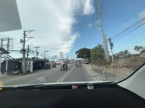
- Street-level photo, Prof_Pickell, CC BY-SA 4.0
- Street-level photo, Prof_Pickell, CC BY-SA 4.0
- Street-level photo, Prof_Pickell, CC BY-SA 4.0
- Street-level photo, Prof_Pickell, CC BY-SA 4.0
- Street-level photo, Prof_Pickell, CC BY-SA 4.0
- Street-level photo, Prof_Pickell, CC BY-SA 4.0


Page built November 7, 2026. Spotted a mistake? Tell us or suggest a place.