


Pico Rivera, California
Pico Rivera is a city of 60,272 people in Los Angeles County, California, founded in 1958.
Why visit Pico Rivera
Townapedia lists 17 museums and landmarks, 25 parks and trails, 91 places to eat, 7 places to stay and 4 attractions in and around town.
Highlights include University of the West, Cinepolis, Casa de Parley Johnson and Clarke Estate.
August is the warmest month, with average highs of 88°F; December lows average 45°F.
Weather in Pico Rivera
Forecast from the National Weather Service. Full forecast
About Pico Rivera
Pico Rivera is a city located in southeastern Los Angeles County, California. As of the 2020 United States census, the city had a population of 62,088. Pico Rivera is bordered by Montebello to the west, Downey to the south, Santa Fe Springs to the southeast, and Whittier to the east.
From the Wikipedia article Pico Rivera, California (this version), under CC BY-SA 4.0.
Things to do4

University of the West
School · 3.9 mi
Buddhist private university in Rosemead, California


Museums and landmarks17
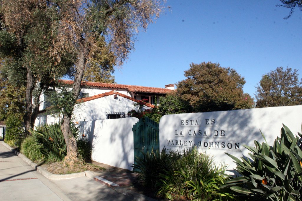
Casa de Parley Johnson
Monument and historic site · National Register of Historic Places · 3.4 mi
Historic house in Downey, California

Clarke Estate
Monument and historic site · National Register of Historic Places · 3.2 mi
Mansion in Santa Fe Springs, California

Golden Gate Theater
Monument and historic site · National Register of Historic Places · 4.4 mi
Former movie theater in East Los Angeles, California, United States, now a drugstore

Hoover Hotel
Monument and historic site · National Register of Historic Places · 3.1 mi
Historic hotel in Whittier, Los Angeles County, Southern California, US

Jonathan Bailey House
Monument and historic site · National Register of Historic Places · 3.3 mi
Historic house in California, United States

National Bank of Whittier Building
Monument and historic site · National Register of Historic Places · 3.1 mi
Historic building in Whittier, California, United States

Oldest McDonald's restaurant
Museum · National Register of Historic Places · 3.4 mi
United States historic places

Orin Jordan House
Monument and historic site · National Register of Historic Places · 3.3 mi
Whittier, California, NRHP-listed

Pio Pico State Historic Park
Monument and historic site · National Register of Historic Places · 1.1 mi
State historic park in Los Angeles County, California, United States

Southern Pacific Railroad Depot, Whittier
Monument and historic site · National Register of Historic Places · 3.1 mi
Railway station in Whittier, the United States of America


Standard Oil Building
Monument and historic site · National Register of Historic Places · 3.2 mi
Historic building in Whittier, California

Armenian Genocide Martyrs Monument
Monument and historic site · 3.6 mi
Monument in Montebello, California, USA
5 more on the map.
Parks, trails and playgrounds25


Greater Whittier Regional Aquatic Center
Sports field and stadium · 1.3 mi
8028 Pioneer Boulevard, Whittier
Mo-Fr 06:00-20:00; Sa 08:00-16:00
Santa Fe Springs Athletic Park
Park · 2.6 mi
9720 Pioneer Boulevard, Santa Fe Springs
Su-Sa 06:00-22:00

Sycamore Canyon Trailhead
Hiking and trails · 2.2 mi
5040 Workman Mill Road, Whittier
Jun-Sep Mo-Su 09:00-18:00; Oct-May Mo-Su 09:00-17:00
Veterans Memorial Park
Park · 2.4 mi
6364 Zindell Avenue, Commerce
13 more on the map.
Restaurants and cafes91

701 Restaurant & Bar
Restaurant · American, Regional, Burger, Brazilian, Mexican · 1.8 mi
620 Whittier Boulevard, Montebello
Mo-Su 11:00-22:00

Starbucks
Cafe · Coffee Shop · 2.3 mi
8801 Lakewood Boulevard, Downey
Mo-Th 04:30-23:00; Fr 04:30-23:30; Sa 05:00-23:30; Su 05:30-23:00
Two Sal's Pizza
Restaurant · Italian, Pizza · 1.4 mi
4528 Rosemead Boulevard
Mo-Sa 11:00-19:30

Ozzie's Diner
Diner · American · 2.2 mi
7780 East Slauson Avenue, Commerce
Mo-Fr 07:00-20:00; Sa-Su 07:00-15:00
Taquearte California
Restaurant · Mexican · 1.4 mi
4518 1/2 Rosemead Boulevard

BIMBO Bakeries USA
Bakery · 2.2 mi
480 South Vail Avenue, Montebello
79 more on the map.
History
Situated on a rich alluvial plain between the Rio Hondo and the San Gabriel River, Pico Rivera was originally two unincorporated agricultural communities: Pico (named for Pío Pico, the last Mexican governor of California and located in the northern portion of what is now Pico Rivera) and Rivera (the Spanish word for "riverbank", located in the southern portion). By the end of the 19th century, the Atchison, Topeka and Santa Fe Railway had been built through Rivera, while the Los Angeles and Salt Lake Railroad (later the Union Pacific) had been built through Pico. In 1902, they were joined by the Pacific Electric's Whittier Line through Rivera. The Los Nietos Townsite Company was established by J. Fletcher Isbell and William T. Bone in 1887, selling land that had once been part of Pio Pico's Rancho Paso de Bartolo. One of their first sales was to Joseph Burke, whose family cultivated orchards and operated a winery near Rivera. The area was served by three schools: Ranchito (northern), Rivera (southern), and Pico (around Jimtown), all of which fed into Whittier Union High School.
From the History section of Pico Rivera, California on Wikipedia, under CC BY-SA 4.0.
Where to stay7
Quality Inn & Suites Montebello - Los Angeles
Motel and hotel · 2.2 mi
7709 Telegraph Road, Montebello
Churches and places of worship46
Saint Mariana de Paredes Catholic Church
Church · Roman Catholic · 1.7 mi
7930 Passons Boulevard, Pico Rivera
Masroor Mosque
Place of worship · Ahmadiyya · 1.2 mi
7419 Passons Boulevard, Pico Rivera
Park Avenue Christian Church
Church · Independent Christian · 2.2 mi
113 South Park Avenue, Montebello
Shopping20
Gas and EV charging23
Schools, colleges and libraries103
Los Nietos Branch County of Los Angeles Public Library
Library · 1.9 mi
8511 Duchess Drive, Whittier
Healthcare5
Wells Medical Office Building
Clinic and pharmacy · 2.7 mi
12462 Putnam Street, Whittier
Map of Pico Rivera
250 places. The map loads OpenStreetMap tiles when you open it.
Climate by month
Monthly table
| Month | High | Low | Rain | Snow |
|---|---|---|---|---|
| Jan | 69°F | 46°F | 3.6 in | 0.0 in |
| Feb | 68°F | 47°F | 4.2 in | 0.0 in |
| Mar | 71°F | 50°F | 2.5 in | 0.0 in |
| Apr | 74°F | 53°F | 0.6 in | 0.0 in |
| May | 76°F | 58°F | 0.5 in | 0.0 in |
| Jun | 81°F | 62°F | 0.1 in | 0.0 in |
| Jul | 86°F | 65°F | 0.0 in | 0.0 in |
| Aug | 88°F | 66°F | 0.0 in | 0.0 in |
| Sep | 87°F | 64°F | 0.1 in | 0.0 in |
| Oct | 81°F | 57°F | 0.6 in | 0.0 in |
| Nov | 74°F | 51°F | 0.9 in | 0.0 in |
| Dec | 68°F | 45°F | 2.4 in | 0.0 in |
U.S. Climate Normals 1991-2020 for San Gabriel Fire Dept (7 mi away), NOAA NCEI.
People and cost of living
American Community Survey 5-year estimates, 2020-2024, U.S. Census Bureau. Estimates have margins of error, larger for small towns.
Disaster history
Los Angeles County has had 67 federal disaster declarations since 2000, most often for fires.
- 2025-08-08: Canyon Fire (Fire)
- 2025-01-08: Wildfires And Straight-Line Winds (Fire)
- 2025-01-08: Eaton Fire (Fire)
- 2025-01-08: Hurst Fire (Fire)
- 2025-01-07: Palisades Fire (Fire)
- 2024-12-10: Franklin Fire (Fire)
OpenFEMA disaster declarations summaries.
Getting there and nearby towns
San Gabriel Valley Airport (EMT) is the nearest airport with scheduled flights listed in OpenStreetMap, 7 miles away.
- West Whittier-Los Nietos 1 mi southeast, about 2 min by car
- Montebello 2 mi northwest, about 4 min by car
- Commerce 4 mi west, about 6 min by car
- Downey 4 mi southwest, about 7 min by car
- Whittier 4 mi east, about 7 min by car
- Bell Gardens 4 mi southwest, about 7 min by car
- Santa Fe Springs 4 mi south, about 7 min by car
- Monterey Park 5 mi northwest, about 8 min by car
- South El Monte 5 mi northeast, about 8 min by car
- South Whittier 5 mi southeast, about 8 min by car
Drive times are estimates from straight-line distance, not routes.
Local news
Headlines from INDB, the NEMICO news database.
Reviews, tips and questions
Loading what members have shared...
Sources and licences
- NCES EDGE (Public domain): public schools
- NOAA NCEI U.S. Climate Normals 1991-2020 (Public domain): climate by month
- OpenFEMA (Public domain): disaster declarations
- OpenStreetMap contributors (ODbL 1.0): places, airports, map data
- U.S. Census Bureau (Public domain): population, income, housing, education, commute
- Wikidata (CC0 1.0): elevation, founding date, time zone, website, landmarks and historic places
- Wikimedia Commons (see each image): photos
- Wikipedia (CC BY-SA 4.0): overview and history text
Photo credits
- PicoRiveraCityHall, Trackinfo, CC BY-SA 3.0
- Southern Pacific Railroad Depot, Whittier, Los Angeles, CC BY-SA 4.0
- Old Theater, 5190 Whittier Blvd., Los Angeles, Los Angeles, CC BY-SA 4.0
- Standard Oil Building, Whittier, Los Angeles, CC BY-SA 4.0
- Hoover Hotel, Whittier, Los Angeles, CC BY-SA 4.0
- Clarke Estate SF Springs CA from Front, Northwalker, CC0
- Jonathan Bailey House, Whittier, Los Angeles, CC BY-SA 4.0
- Orin Jordan House, Whittier, Los Angeles, CC BY-SA 4.0
- National Bank of Whittier Building, Los Angeles, CC BY-SA 4.0
- ParleyJohnson, Floatjon, CC BY-SA 3.0
- Pio Pico State Historic Park 2007, Epolk, CC BY-SA 4.0
- STS133-E-7972 - View of California, NASA, Public domain
- ISS036-E-24156 - View of Earth, Earth Science and Remote Sensing Unit , Lyndon B. Johnson Space Center, Public domain
- ISS066-E-51320 - View of Earth, Earth Science and Remote Sensing Unit , Lyndon B. Johnson Space Center, Public domain
- ISS066-E-50290 - View of Earth, Earth Science and Remote Sensing Unit , Lyndon B. Johnson Space Center, Public domain
- ISS027-E-28810 - View of Earth, Earth Science and Remote Sensing Unit , Lyndon B. Johnson Space Center, Public domain
- ISS061-E-28694 - View of Earth, Earth Science and Remote Sensing Unit, NASA Johnson Space Center, Public domain
- STS133-E-7973 - View of California, NASA, Public domain
- Zoanthus polyps, Inktomi, CC BY-SA 4.0
- Ranitomeya imitator 'Chazuta', Inktomi, CC BY-SA 4.0
- Montipora macro photo, Inktomi, CC BY-SA 4.0
- Overview of Battle of Rio San Gabriel, Oscar morales5, CC BY-SA 3.0
- CHL- 385 - Rio San Gabriel Battlefield (4430196506), Konrad Summers from Santa Clarita (Valencia) , California, USA, CC BY-SA 2.0
- LA River at 710 night aerial, Dicklyon, CC BY-SA 4.0
- 2021-10-05 14 19 14 View southwest along the San Gabriel River and Interstate 605 towards San Pedro Bay and the Port of Long Beach in southern Los Angeles County, California from an airplane heading..., Famartin, CC BY-SA 4.0
- 2021-10-05 14 19 10 View southwest towards San Pedro Bay and the Port of Long Beach in southern Los Angeles County, California from an airplane heading toward Los Angeles International Airport, Famartin, CC BY-SA 4.0
- Postal Road Trips - Montebello CA, PostalRoadTrips, CC BY-SA 4.0
- Firestone Blvd at 605, Norwalk, San Gabriel River and Rio San Gabriel Park, Downey, Dicklyon, CC BY 4.0
- Palm park, Whittier, California 0, Northwalker, CC0
- 2021-10-05 14 19 29 View southwest along the San Gabriel River and Interstate 605 towards San Pedro Bay and the Port of Long Beach in southern Los Angeles County, California from an airplane heading..., Famartin, CC BY-SA 4.0
- Whittier Greenway Trail Palm Park, Northwalker, CC0
- Palm park, Whittier, California 2, Northwalker, CC0
- Los Angeles County (26860418492), Sergei Gussev, CC BY 2.0
- Los Angeles County (26349214334), Sergei Gussev, CC BY 2.0
- Los Angeles County (26886158681), Sergei Gussev, CC BY 2.0
- 69 CHEVY IMPALA, Accord14, CC BY-SA 4.0
- Public Storage Montebello, Eric Polk, CC BY-SA 4.0
- 2021-10-05 14 19 35 View southwest along the Los Angeles River towards San Pedro Bay and the Port of Long Beach in southern Los Angeles County, California from an airplane heading toward Los Angeles..., Famartin, CC BY-SA 4.0
- Old Camry, Accord14, CC BY-SA 4.0
- Estes Express Lines semi-trailer, Eric Polk, CC BY-SA 4.0


Page built October 30, 2026. Spotted a mistake? Tell us or suggest a place.