
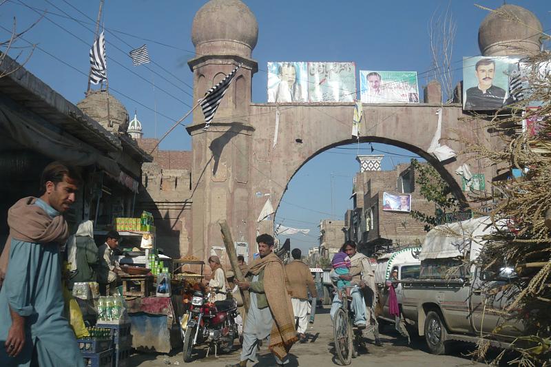

Bannu, Pakistan
بنوں
Bannu is a town of 1,357,890 people in Khyber Pakhtunkhwa, Pakistan.
Why visit Bannu
Townapedia lists 2 museums and landmarks, 8 parks and trails and 1 place to eat in and around town.
Highlights include Bannu Museum and Milad Park Bannu.
Weather in Bannu
Forecast from MET Norway (CC BY 4.0). Full forecast
About Bannu
Bannu (Urdu: بنوں, romanized: bannū̃, pronounced [bənːũː] ), also called Bani Gul or Bani (Pashto: باني, romanized: bānī, pronounced [ˈbɑni] ) is a city located on the Kurram River in southern Khyber Pakhtunkhwa, Pakistan. It is the capital of Bannu Division. Bannu's residents are primarily members of the Banuchi tribe and speak Banuchi (Baniswola), a dialect of Pashto which is similar to the distinct Waziristani dialect. The residents regardless of their tribes are commonly called Banusi, Banuchi or Banisi.
From the Wikipedia article Bannu (this version), under CC BY-SA 4.0.
Museums and landmarks2

Bannu Museum
Museum · 0.9 km
Archaeology museum in Khyber Pakhtunkhwa, Pakistan

Parks, trails and playgrounds8


Restaurants and cafes1

Churches and places of worship2

History
The history of Bannu goes back to prehistoric time, due to its strategic location along the Kurram and Tochi routes which lead into the Indus Valley. Sheri Khan Tarakai is an ancient settlement site located in the Bannu District with ruins of the oldest known village settlement in the Bannu region, which was occupied from the late fifth until the early third millennium BCE. Recent archaeological excavations at Akra, Bannu showed that it was a large urban site that existed throughout the Iron Age and had trade relations with Central Asia.
The sacred texts of Zend Avesta and Vendidad mentions Varəna, the Avestan predecessor of the name for Bannu, as the 14th in the list of the "16 perfect lands" created by Ahura Mazda. According to the Avesta, Varəna was the homeland and birthplace of the legendary King Fereydun (known in Avestan as Θraētaona, and also known as Āθβiiāni, "of the house of Abtin").
From the History section of Bannu on Wikipedia, under CC BY-SA 4.0.
Gas and EV charging3
Schools, colleges and libraries10
Healthcare4
Map of Bannu
30 places. The map loads OpenStreetMap tiles when you open it.
Getting there and nearby towns
Bannu Airport (BNP) is the nearest airport with scheduled flights listed in OpenStreetMap, 8 km away.
- Sarai Naurang 24 km southeast, about 24 min by car
- Karak 48 km east, about 48 min by car
- Doaba 50 km north, about 50 min by car
- Miran Shah 50 km west, about 50 min by car
- Lakki 51 km southeast, about 51 min by car
- Alizai 66 km north, about 1 h by car
- Abdul Khel 71 km southeast, about 1 h 15 min by car
- Kamar Mushani 72 km east, about 1 h 15 min by car
- Hangu 74 km northeast, about 1 h 15 min by car
- Lachi 81 km northeast, about 1 h 15 min by car
Drive times are estimates from straight-line distance, not routes.
Local news
Headlines from INDB.
Reviews, tips and questions
Loading what members have shared...
Sources and licences
- GeoNames (CC BY 4.0): population, coordinates, regions and time zone
- OpenStreetMap contributors (ODbL 1.0): places, airports, map data
- Wikidata (CC0 1.0): elevation, founding date, time zone, website, landmarks and historic places
- Wikimedia Commons (see each image): photos
- Wikipedia (CC BY-SA 4.0): overview and history text
Photo credits
- Bannu, Pakistan, Omer Wazir from Tucson, AZ, USA, CC BY-SA 2.0
Page built November 3, 2026. Spotted a mistake? Tell us or suggest a place.