




Mandi Bahauddin, Pakistan
منڈی بہاوالدین
Mandi Bahauddin is a town of 129,733 people in Punjab, Pakistan, founded in 1506.
Why visit Mandi Bahauddin
Townapedia lists 3 museums and landmarks, 1 park or trail, 6 places to stay and 2 attractions in and around town.
Highlights include Government College of Technology, Rasul and University of Engineering & Technology, Rasul.
Weather in Mandi Bahauddin
Forecast from MET Norway (CC BY 4.0). Full forecast
About Mandi Bahauddin
Mandi Bahauddin (Punjabi / Urdu: مَنْڈی بَہَاءُ الدِّین, romanized: manḍī bahā-ud-dīn Punjabi: [mɐ̃ɳˈɖiː ˈbä˥ʊ̯˩d̪ˑiːnᵊ]; Urdu: [mə̃nˈɖiː ˈbəɦɑːʊ̯d̪.d̪iːn]) is a city in Punjab, Pakistan. It is also called "The City of Lions" and "The Land of Judges". It is also the capital of Mandi Bahauddin District. It is the 43rd most populous city in Pakistan, according to the 2023 census.
From the Wikipedia article Mandi Bahauddin (this version), under CC BY-SA 4.0.
Travel tips from other travellers: Mandi Bahauddin on Wikivoyage (CC BY-SA 4.0).
Things to do2
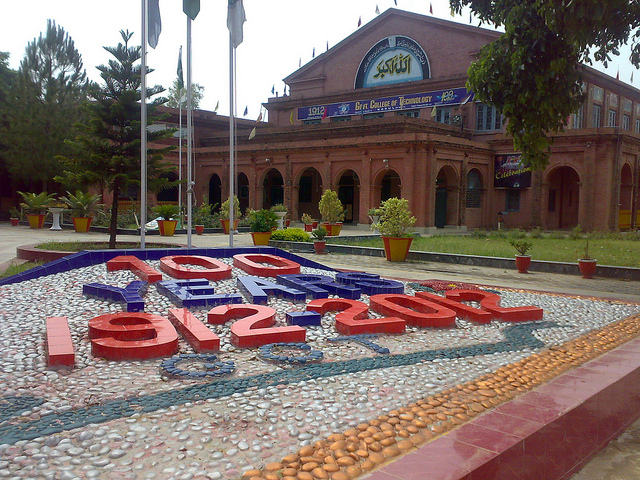
Government College of Technology, Rasul
School · 12.0 km
Engineering college in Rasul, Pakistan
Museums and landmarks3

Parks, trails and playgrounds1

Where to stay6

Dera Sardary Ka
Motel and hotel · 11.9 km
Rest house owned by Ijaz Ahmed Gondal
سڑک سرگودھا, بھکھی شریف
Dara sardary ka
Motel and hotel · 12.0 km
Rest house owned by Haji Manik Ali & Sons
12 سڑک سرگودھا, بھکھی شریف
Haweli Adeel Safdar Tarar
Motel and hotel · 8.3 km
Tarar rd منڈی بہاؤالدین - پھالیہ سڑک, mangat
Churches and places of worship3
Darbar Mohammad Jalal-ud-Din Shah, Bhikhi Sharif
Place of worship · Sunni · 11.6 km
Shopping4
Gas and EV charging7
Schools, colleges and libraries4
Healthcare3
Map of Mandi Bahauddin
33 places. The map loads OpenStreetMap tiles when you open it.
Getting there and nearby towns
Mangla (XJM) is the nearest airport with scheduled flights listed in OpenStreetMap, 53 km away.
- Lollianwala 11 km northeast, about 11 min by car
- Phalia 19 km southeast, about 19 min by car
- Dinga 22 km east, about 22 min by car
- Malakwal 26 km west, about 26 min by car
- Malakwal City 26 km west, about 26 min by car
- Sarai Alamgir 43 km northeast, about 43 min by car
- Jhelum 45 km northeast, about 45 min by car
- Wazirabad 61 km east, about 1 h by car
- New Mirpur City 67 km north, about 1 h by car
- Gujranwala 81 km southeast, about 1 h 15 min by car
Drive times are estimates from straight-line distance, not routes.
Local news
Headlines from INDB.
Reviews, tips and questions
Loading what members have shared...
Sources and licences
- GeoNames (CC BY 4.0): population, coordinates, regions and time zone
- OpenStreetMap contributors (ODbL 1.0): places, airports, map data
- Wikidata (CC0 1.0): elevation, founding date, time zone, website, landmarks and historic places
- Wikimedia Commons (see each image): photos
- Wikipedia (CC BY-SA 4.0): overview and history text
Photo credits
- Sunrise in Mandi Bahauddin, Hussain Ali Zaidi, CC BY-SA 4.0
- GCT-Rasul (photo), Hasnimirza, CC BY-SA 3.0
- IMG-20151222-WA0001, Attaurrahman007, CC BY-SA 4.0
- حویلی جاوید اقبال گوندل - panoramio, SAMEER GONDAL, CC BY 3.0
- JAVED IQBAL GONDAL HOME - panoramio, SAMEER GONDAL, CC BY 3.0
- حویلی جاوید اقبال گوندل - panoramio (1), SAMEER GONDAL, CC BY 3.0
- 23-08-2014 - panoramio (1), SAMEER GONDAL, CC BY 3.0
- 23-08-2014 - panoramio, SAMEER GONDAL, CC BY 3.0
- راستہ ڈیرہ چوہدری محمد خاں گوندل - panoramio, SAMEER GONDAL, CC BY 3.0
- ڈیرہ چوہدری محمد خاں گوندل - panoramio (1), SAMEER GONDAL, CC BY 3.0
- ڈیرہ چوہدری محمد خاں گوندل - panoramio, SAMEER GONDAL, CC BY 3.0
- Beautiful scene fields in Taratebe - Sultan Jut - panoramio, Muhammad Ibrahim sgd, CC BY-SA 3.0
- View of Taratebe - Sultan Jut - panoramio, Muhammad Ibrahim sgd, CC BY-SA 3.0
- Goats - panoramio (5), Muhammad Ibrahim sgd, CC BY-SA 3.0
- Beautiful scene of morning in Taratebe - Sultan Jut - panoramio, Muhammad Ibrahim sgd, CC BY-SA 3.0
- ISS036-E-36194 - View of Earth, Earth Science and Remote Sensing Unit , Lyndon B. Johnson Space Center, Public domain
- ISS053-E-273050 - View of Earth, Earth Science and Remote Sensing Unit , Lyndon B. Johnson Space Center, Public domain
- ISS053-E-257679 - View of Earth, Earth Science and Remote Sensing Unit , Lyndon B. Johnson Space Center, Public domain
- ISS036-E-36193 - View of Earth, Earth Science and Remote Sensing Unit , Lyndon B. Johnson Space Center, Public domain
- ISS062-E-34794 - View of Earth, Earth Science and Remote Sensing Unit, NASA Johnson Space Center, Public domain
- ISS065-E-194258 - View of Earth, Earth Science and Remote Sensing Unit , Lyndon B. Johnson Space Center, Public domain
- ISS015-E-5249 - View of Pakistan, Earth Science and Remote Sensing Unit , Lyndon B. Johnson Space Center, Public domain
- ISS062-E-34796 - View of Earth, Earth Science and Remote Sensing Unit, NASA Johnson Space Center, Public domain
- ISS062-E-34797 - View of Earth, Earth Science and Remote Sensing Unit, NASA Johnson Space Center, Public domain
- ISS053-E-257680 - View of Earth, Earth Science and Remote Sensing Unit , Lyndon B. Johnson Space Center, Public domain
- ISS053-E-273051 - View of Earth, Earth Science and Remote Sensing Unit , Lyndon B. Johnson Space Center, Public domain
- ISS062-E-34795 - View of Earth, Earth Science and Remote Sensing Unit, NASA Johnson Space Center, Public domain
- ISS014-E-11810 - View of India, Earth Science and Remote Sensing Unit , Lyndon B. Johnson Space Center, Public domain
- ISS062-E-34799 - View of Earth, Earth Science and Remote Sensing Unit, NASA Johnson Space Center, Public domain
- ISS062-E-34798 - View of Earth, Earth Science and Remote Sensing Unit, NASA Johnson Space Center, Public domain
- ISS062-E-34801 - View of Earth, Earth Science and Remote Sensing Unit, NASA Johnson Space Center, Public domain
- ISS065-E-194259 - View of Earth, Earth Science and Remote Sensing Unit , Lyndon B. Johnson Space Center, Public domain
- ISS062-E-34800 - View of Earth, Earth Science and Remote Sensing Unit, NASA Johnson Space Center, Public domain


Page built November 3, 2026. Spotted a mistake? Tell us or suggest a place.