



Why visit Rohri
Townapedia lists 5 museums and landmarks, 16 parks and trails, 73 places to eat, 27 places to stay and 4 attractions in and around town.
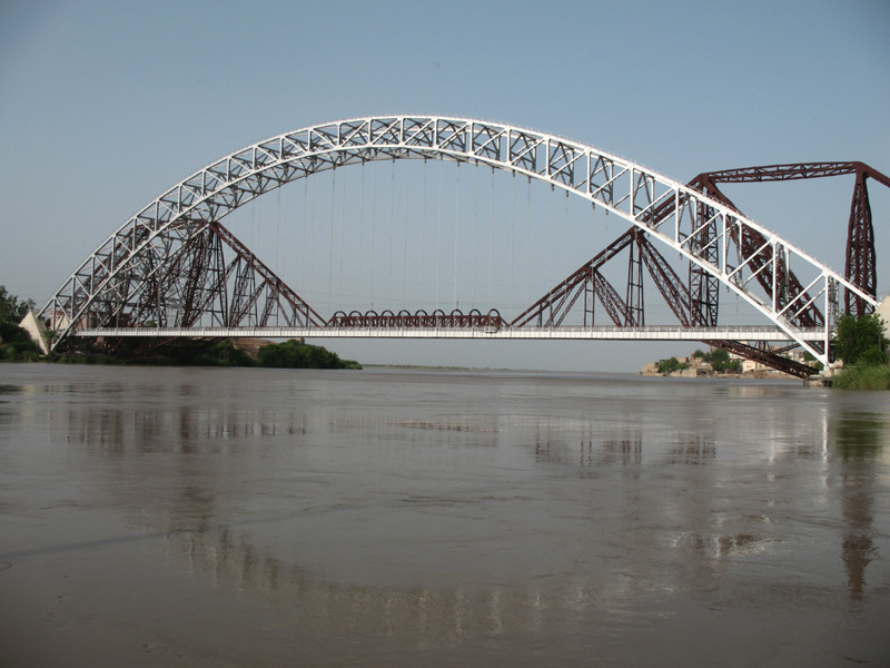
Highlights include Ayub Bridge, Begum Nusrat Bhutto Women University, Lloyd Barrage Museum and Lab-e-Mehran.
Weather in Rohri
Forecast from MET Norway (CC BY 4.0). Full forecast
About Rohri
Rohri (Sindhi: روهڙي; Urdu: روہڑی) is a city of Sukkur District, Sindh province, Pakistan. It is located on the east bank of the Indus River, directly across from Sukkur, the third most populous city in Sindh. Rohri town is the administrative headquarters of Rohri Taluka, and a tehsil of Sukkur District with which it forms a metropolitan area. Its capture marked the beginning of Muslim rule in India under Muhammad ibn al-Qasim in 711 CE, when it was named Aror.
From the Wikipedia article Rohri (this version), under CC BY-SA 4.0.
Things to do4

Begum Nusrat Bhutto Women University
School · 4.2 km
University in Sindh, Pakistan



Museums and landmarks5


Parks, trails and playgrounds16


Imam Mahdi AS Water Park
Sports field and stadium · 0.7 km
Lansdowne Bridge Road, Sukkur
King Mengh Water Park
Sports field and stadium · 4.9 km
National Highway 5, Rohri
Nasir Chohan Regional Sport Club Stadium
Sports field and stadium · 10.6 km
Shikarpur Road, Sukkur

4 more on the map.
Restaurants and cafes73

FishKar
Restaurant · Chicken, Coffee Shop, Diner, Fine Dining, Fish, Fish And Chips, Kebab · 8.6 km
100 Ft Road Opposite IBA Sukkur
Mo-Su 16:00-01:00
HD - Hotel Dreha Family Restaurant
Restaurant · Pakistani · 12.7 km
Sukkur-Jacobabad Highway, Sukkur

61 more on the map.
History
Rohri is 10 kilometres (6.2 miles) west of the ancient city of Aror. Roruka, as capital of the Sauvira Kingdom, is mentioned as an important trading center in early Buddhist literature. Little is known about the city's history prior to the Arab invasion in the eighth century, but Aror was the capital of the Rai dynasty and then the Brahman dynasty that once ruled northern Sindh.
In 711 CE, Aror was captured by the army of Muslim general Muhammad bin Qasim. In 962 CE, a massive earthquake struck the region, causing the course of the Indus River to shift. Aror was re-founded as Rohri afterwards.
Rohri served as a busy port along the Indus by the 1200s, and was a major trading centre for agricultural produce.
From the History section of Rohri on Wikipedia, under CC BY-SA 4.0.
Where to stay27
Alydia Inn Guest House
Motel and hotel · 5.4 km
Sindhi Cooperative Housing Society, Sukkur
Bhitai Nagar
Motel and hotel · 5.9 km
Friends Cooperative Housing Society, Sukkur
Decent Lodges Sukkhar
Motel and hotel · 5.5 km
Sindhi Cooperative Housing Society, Sukkur
Green Palace Guest House
Motel and hotel · 5.4 km
Sindhi Cooperative Housing Society, Sukkur
IBA Hostel 8
Motel and hotel · 5.7 km
Hamdard Cooperative Housing Society, Sukkur
IBA Hostel No 10
Motel and hotel · 5.9 km
Hamdard Cooperative Housing Society, Sukkur
IBA Hostel No.3
Motel and hotel · 6.0 km
Friends Cooperative Housing Society, Sukkur
Indus Guest House
Motel and hotel · 5.6 km
Sindhi Cooperative Housing Society, Sukkur
Churches and places of worship35
Jamia Masjid Khatam Ul Anbiya
Place of worship · Sunni · 1.8 km
Masoom Shan Minar Road, Sukkur
Muslim Bin Aqeel
Place of worship · Sunni · 8.9 km
Sukkur Bypass link road, Sukkur
Sheikh Sheen Badshah Mosque
Place of worship · Sunni · 3.3 km
Cinema Road, Sukkur
Shopping13
Ameer Hamza Kiryana Store
Grocery · 6.8 km
Professors Cooperative Housing Society, Sukkur
Ghouri Icon 2 Society Branch
Grocery · 5.5 km
Sindhi Cooperative Housing Society, Sukkur
Maillani General Store
Grocery · 5.6 km
Sindhi Cooperative Housing Society, Sukkur
Gas and EV charging40
Murshid Filling Station Total Petrol Station
Gas station · 4.9 km
Military Road, Sukkur
Schools, colleges and libraries29
Allama Iqbal Open University Regional Center Sukkur
School · 6.8 km
Jaffria Cooperative Housing Society, Sukkur
Government Comprehensive Higher Secondary School
School · 5.7 km
Shikarpur Road, Sukkur
Healthcare20
Al Rehman Maternity Home
Clinic and pharmacy · 4.8 km
Sindh Muslim Cooperative Housing Society, Sukkur
Marie Stopes Regional Office Sukkur
Hospital · 5.9 km
Friends Cooperative Housing Society, Sukkur
Map of Rohri
250 places. The map loads OpenStreetMap tiles when you open it.
Getting there and nearby towns
Sukkur Airport (SKZ) is the nearest airport with scheduled flights listed in OpenStreetMap, 11 km away.
- Sukkur 4 km west, about 4 min by car
- Bagarji 15 km northwest, about 15 min by car
- Chak 19 km north, about 19 min by car
- Khairpur Mir’s 22 km southwest, about 22 min by car
- Lakhi 26 km northwest, about 26 min by car
- Pano Aqil 28 km northeast, about 28 min by car
- Pir Jo Goth 29 km west, about 29 min by car
- Rustam 32 km north, about 32 min by car
- Shikarpur 39 km northwest, about 39 min by car
- Jacobabad 79 km northwest, about 1 h 15 min by car
Drive times are estimates from straight-line distance, not routes.
Local news
Headlines from INDB.
Reviews, tips and questions
Loading what members have shared...
Sources and licences
- GeoNames (CC BY 4.0): population, coordinates, regions and time zone
- OpenStreetMap contributors (ODbL 1.0): places, airports, map data
- Wikidata (CC0 1.0): elevation, founding date, time zone, website, landmarks and historic places
- Wikimedia Commons (see each image): photos
- Wikipedia (CC BY-SA 4.0): overview and history text
Photo credits
- The town of Roree, and the Fortress of Bukker on the Indus, Haghe, Louis, 1806-1885, lithographer; Atkinson, James, 1780-1852, artist; Haghe, Charles, -1888, lithographer, Public domain
- Lansdowne Bridge Rohri, سیانف, CC BY-SA 3.0
- Shah e Najaf Rohri - panoramio, sajidmirani125, CC BY-SA 3.0
- Aerial View of Sukkur Lansdowne Bridge and Sukkur Rohri, Mhtoori, CC BY-SA 4.0
- Ayub, Rajaislam, CC BY 2.0
- Panorama of Lansdowne Bridge Sukkur, Mhtoori, CC BY-SA 4.0
- ISS061-E-4125 - View of Earth, Earth Science and Remote Sensing Unit, NASA Johnson Space Center, Public domain
- ISS061-E-4124 - View of Earth, Earth Science and Remote Sensing Unit, NASA Johnson Space Center, Public domain
- Sukkur Pakistan Haddid - panoramio, Haddid Uddin, CC BY 3.0
- SQZSB HOME - panoramio, syed qamar zaman sha…, CC BY 3.0
- Mama Parsi Zoroastrian Fire Temple Sukkur built in 1923, مھتاب احمد سنڌي, CC BY-SA 4.0
- Bridge over the Indus, Sukkur (Landsdowne Bridge) (8091109057), Mike, CC BY-SA 2.0
- 'Duck shoot at Drig H.E. & Her Ex.' (8091085467), Mike, CC BY-SA 2.0
- 'Duck shoot at Drig some of the beaters' (8091076001), Mike, CC BY-SA 2.0
- 'Duck shoot at Drig' (8091087966), Mike, CC BY-SA 2.0
- Sukkur (8091100765), Mike, CC BY-SA 2.0
- Minaret of Masum Shah, سیانف, CC BY-SA 3.0
- Bridge over the Indus, Sukkur (Landsdowne Bridge) (8091112164), Mike, CC BY-SA 2.0
- 'Duck shoot at Drig' (my but?) (8091085296), Mike, CC BY-SA 2.0
- Sukkur (8091098095), Mike, CC BY-SA 2.0
- 'Duck shoot at Drig' (8091073735), Mike, CC BY-SA 2.0
- 'Duck shoot at Drig H.E.' (8091094194), Mike, CC BY-SA 2.0
- 'Duck shoot at Drig' (8091076560), Mike, CC BY-SA 2.0
- Sindhi Books, مھتاب احمد سنڌي, CC BY-SA 4.0
- Sukkur (8091136028), Mike, CC BY-SA 2.0
- Ahmed Ali Mangrio, Ahmedmangrio, CC BY 3.0
- Sukkar - panoramio, Najamuddin Shahwani, CC BY 3.0
- Sukkar Jail - panoramio, Najamuddin Shahwani, CC BY 3.0
- Buffalo's Taking bath - panoramio, Najamuddin Shahwani, CC BY 3.0
- Government College of Education Sukkur, مھتاب احمد سنڌي, CC BY-SA 4.0
- Foundation stone of Government College of Education Sukkur, مھتاب احمد سنڌي, CC BY-SA 4.0
- Front view of GCE Sukkur, مھتاب احمد سنڌي, CC BY-SA 4.0
- Caccobius pantherinus Arrow, 1931 male (4497474282), Udo Schmidt from Deutschland, CC BY-SA 2.0
- IBA Sukkur - panoramio, ANEES_KHADIM, CC BY 3.0
- Sukkur IBA University Academic Block III, مھتاب احمد سنڌي, CC BY-SA 4.0
- ISS061-E-4123 - View of Earth, Earth Science and Remote Sensing Unit, NASA Johnson Space Center, Public domain
- Wilson Bahadur (8091121484), Mike, CC BY-SA 2.0
- 'Water wheel' (8091138764), Mike, CC BY-SA 2.0


Page built November 3, 2026. Spotted a mistake? Tell us or suggest a place.