


Why visit Pocahontas
Townapedia lists 8 museums and landmarks, 5 parks and trails, 9 places to eat, 1 place to stay and 3 attractions in and around town.
Highlights include Old Randolph County Courthouse and Pocahontas Commercial Historic District.
July is the warmest month, with average highs of 90°F; January lows average 26°F.
Weather in Pocahontas
Forecast from the National Weather Service. Full forecast
About Pocahontas
Pocahontas is a city in and the county seat of Randolph County, Arkansas, United States, along the Black River. As of the 2020 census, Pocahontas had a population of 7,371.
From the Wikipedia article Pocahontas, Arkansas (this version), under CC BY-SA 4.0.
Things to do3

Imperial Dinner Theater
Cinema and theater · 2.0 mi
1401 Highway 304 E, Pocahontas

Museums and landmarks8

Old Randolph County Courthouse
Monument and historic site · National Register of Historic Places
Courthouse in Arkansas, United States

Pocahontas Commercial Historic District
Monument and historic site · National Register of Historic Places
Historic district in Arkansas, United States

Pocahontas Post Office
Monument and historic site · National Register of Historic Places
Post office in Pocahontas, United States of America
Black River Bridge
Monument and historic site · National Register of Historic Places · 0.6 mi
Bridge in United States of America


Marr's Creek Bridge
Bridge · National Register of Historic Places
Public Works Administration bridge in Pocahontas, Arkansas
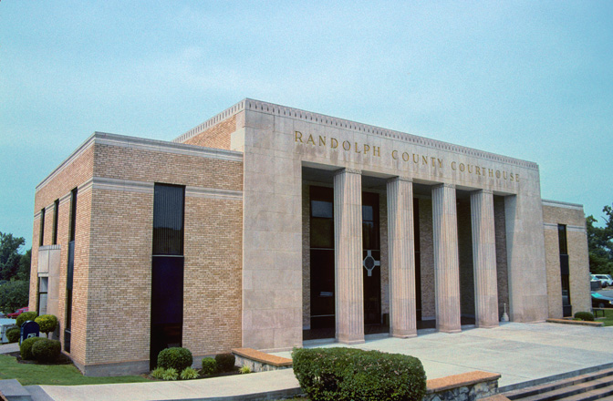
Randolph County Courthouse
Monument and historic site · National Register of Historic Places
Courthouse in Arkansas, United States

Parks, trails and playgrounds5


Restaurants and cafes9



History
This city was named after the Native American from Jamestown, Virginia. A statue of her is located in Overlook Park along the Black River.
The family of Dr. Ransom S. Bettis is given the credit for being the first settlers on the land now called Pocahontas. Dr. Bettis' daughter, Cinderella, married Thomas S. Drew, and lived on 800 acres where the town of Biggers now exists. Bettis and Drew led the founding of Pocahontas as the county seat of Randolph County.
Randolph County is famous for many "firsts"; Arkansas' oldest town, Davidsonville, was established in 1815. The first Arkansas post office was built in Davidsonville in 1817, and the first state courthouse was established in 1818. The earliest land claim was in 1809 near what is now Ravenden Springs. The first actual term of court convened in Arkansas was in 1815 in a part of Lawrence County that was given over to Randolph County. And the country's first overland route, the Natchitoches Trail (Natchitoches Trace), went through parts of Randolph County.
In 1835, the Territorial Legislature granted the formation of Randolph County from part of the area then called Lawrence County. The county was named after John Randolph, who was one of the first settlers in the area.
From the History section of Pocahontas, Arkansas on Wikipedia, under CC BY-SA 4.0.
Where to stay1
Churches and places of worship7
Eddie Mae Herron Center & Museum
Church · National Register of Historic Places · 0.6 mi
Saint Paul Catholic Church
Church · Roman Catholic
1002 Convent Street, Pocahontas
Shopping4
Gas and EV charging4
Schools, colleges and libraries12
Black River Technical College Career Center (Topps)
School · 2.0 mi
1410 Highway 304 East, Pocahontas
Healthcare2
Map of Pocahontas
55 places. The map loads OpenStreetMap tiles when you open it.
Climate by month
Monthly table
| Month | High | Low | Rain | Snow |
|---|---|---|---|---|
| Jan | 46°F | 26°F | 3.8 in | 2.3 in |
| Feb | 50°F | 29°F | 3.9 in | 1.9 in |
| Mar | 60°F | 38°F | 4.7 in | 1.4 in |
| Apr | 71°F | 46°F | 5.4 in | 0.0 in |
| May | 79°F | 56°F | 5.4 in | 0.0 in |
| Jun | 87°F | 65°F | 3.5 in | 0.0 in |
| Jul | 90°F | 69°F | 3.6 in | 0.0 in |
| Aug | 89°F | 68°F | 3.9 in | 0.0 in |
| Sep | 83°F | 60°F | 3.8 in | 0.0 in |
| Oct | 72°F | 47°F | 3.9 in | 0.1 in |
| Nov | 59°F | 36°F | 4.8 in | 0.2 in |
| Dec | 48°F | 29°F | 4.7 in | 0.4 in |
U.S. Climate Normals 1991-2020 for Pocahontas 1 Hcn (0 mi away), NOAA NCEI.
People and cost of living
American Community Survey 5-year estimates, 2020-2024, U.S. Census Bureau. Estimates have margins of error, larger for small towns.
Disaster history
Randolph County has had 21 federal disaster declarations since 2000, most often for severe storms.
- 2026-01-24: Severe Winter Storm (Winter Storm)
- 2025-05-21: Severe Storms, Tornadoes, And Flooding (Flood)
- 2025-05-08: Severe Storms And Tornadoes (Severe Storm)
- 2025-04-05: Severe Storms, Tornadoes, And Flooding (Severe Storm)
- 2024-05-30: Severe Storms, Straight-Line Winds, Tornadoes, And Flooding (Severe Storm)
- 2020-08-27: Hurricane Laura (Hurricane)
OpenFEMA disaster declarations summaries.
Getting there and nearby towns
Walnut Ridge Regional Airport (ARG) is the nearest airport with scheduled flights listed in OpenStreetMap, 10 miles away.
- Walnut Ridge 12 mi south, about 20 min by car
- Hoxie 16 mi south, about 25 min by car
- Corning 24 mi northeast, about 39 min by car
- Doniphan 26 mi north, about 42 min by car
- Paragould 30 mi southeast, about 48 min by car
- Highland 31 mi west, about 49 min by car
- Cherokee Village 33 mi west, about 54 min by car
- Brookland 33 mi southeast, about 54 min by car
- Marmaduke 33 mi east, about 53 min by car
- Jonesboro 35 mi southeast, about 56 min by car
Drive times are estimates from straight-line distance, not routes.
Local news
Headlines from INDB, the NEMICO news database.
Reviews, tips and questions
Loading what members have shared...
Sources and licences
- NCES EDGE (Public domain): public schools
- NOAA NCEI U.S. Climate Normals 1991-2020 (Public domain): climate by month
- OpenFEMA (Public domain): disaster declarations
- OpenStreetMap contributors (ODbL 1.0): places, airports, map data
- U.S. Census Bureau (Public domain): population, income, housing, education, commute
- Wikidata (CC0 1.0): elevation, founding date, time zone, website, landmarks and historic places
- Wikimedia Commons (see each image): photos
- Wikipedia (CC BY-SA 4.0): overview and history text
Photo credits
- ChrisLitherlandPocahantas, Chris Litherland (photolitherland), CC BY-SA 3.0
- Pocahontas AR Old Courthouse, NatalieMaynor, CC BY 2.0
- Front view of the Old Pocahontas Post Office, now the office of the Pocahontas Star Herald, Asimov72455, CC BY-SA 3.0
- Black River Bridge, Spanning Black River at U.S. Highway 67, Pocahontas (Randolph County, Arkansas), Louise T. Taft, Public domain
- Colored school and museum, Asimov72455, CC BY-SA 3.0
- Randolph County Arkansas Courthouse, Calvin Beale, Public domain
- Marr's Creek Bridge NRHP 07001433 Randolph County, AR, Jon Roanhaus, CC BY-SA 4.0
Page built October 30, 2026. Spotted a mistake? Tell us or suggest a place.