
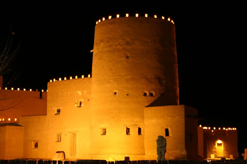

Pojoaque, New Mexico
Pojoaque is a community of 2,327 people in Santa Fe County, New Mexico.
Why visit Pojoaque
Townapedia lists 4 museums and landmarks, 3 parks and trails, 12 places to eat and 3 places to stay in and around town.
Highlights include Poeh Cultural Center, Nambé Pueblo and Pueblo Revolt Tricenteninnial Historical Marker.
July is the warmest month, with average highs of 91°F; December lows average 16°F.
Weather in Pojoaque
Forecast from the National Weather Service. Full forecast
About Pojoaque
The Pueblo of Pojoaque (Tewa: Pʼohsųwą̈geh Ówîngeh, pronounced [pʼòhsũ̀wæ̃̀ɡè ʔówîŋɡè], lit. 'water-drinking place village') is an Indian reservation in Santa Fe County, New Mexico, United States. It is part of the Santa Fe, New Mexico, Metropolitan Statistical Area.
From the Wikipedia article Pueblo of Pojoaque (this version), under CC BY-SA 4.0.
Museums and landmarks4



Nambé Pueblo
Monument and historic site · National Register of Historic Places · 2.7 mi
Human settlement in New Mexico, United States of America
Poeh Museum
Museum · 1.0 mi
Native American art museum in Pojoaque, New Mexico

Parks, trails and playgrounds3

Restaurants and cafes12

Pizza Etc.
Restaurant · Pizza · 0.8 mi
68 Cities of Gold Road, Santa Fe
Mo-Th 11:00-20:00; Fr-Su 11:00-21:00
Sopaipilla Factory Restaurant
Restaurant · New Mexican · 0.9 mi
7 West Gutierrez Street, Pojoaque
Mo-Sa 11:00-21:00; Su 10:00-15:00

El Parasol
Restaurant · Mexican, Burrito, New Mexican, Regional · 0.8 mi
30 Cities of Gold Road, Santa Fe

Where to stay3


History
Pojoaque Pueblo is one of the six Tewa-speaking Rio Grande Pueblos, and a member of the Eight Northern Pueblos. The Pueblo was settled around 500 AD, with the population peaking in the 15th and 16th centuries. Tewa tradition describes Pojoaque as a "mother village" where their ancestors gathered before spreading across the Tewa Basin.
In the early 17th century, the first Spanish mission, San Francisco de Pojoaque was founded. During the Pueblo Revolt of 1680, Pojoaque was abandoned, and was not resettled until circa 1706. By 1712, the population had reached 79. During the revolt of 1837, New Mexico Governor Manuel Armijo defeated the rebels at Puertocito Pojoaque, east of Santa Cruz de la Cañada. In the early 1900s, the Pojoaque Valley School District was established to serve the educational needs of the valley.
Around 1900, a severe smallpox epidemic caused the pueblo to be abandoned once again by 1912. In 1934, Pojoaque Pueblo was reoccupied, and became a federally recognized Indian reservation in 1936.
From the History section of Pueblo of Pojoaque on Wikipedia, under CC BY-SA 4.0.
Churches and places of worship6
Nuestra Señora de Guadalupe del Valle de Pojoaque Catholic Church
Church · Roman Catholic · 0.8 mi
9 Grazing Elk Drive, Pojoaque
Shopping2
Gas and EV charging2
Schools, colleges and libraries11
Map of Pojoaque
43 places. The map loads OpenStreetMap tiles when you open it.
Climate by month
Monthly table
| Month | High | Low | Rain |
|---|---|---|---|
| Jan | 48°F | 16°F | 0.7 in |
| Feb | 55°F | 21°F | 0.6 in |
| Mar | 62°F | 26°F | 0.9 in |
| Apr | 70°F | 33°F | 0.7 in |
| May | 78°F | 40°F | 0.7 in |
| Jun | 89°F | 49°F | 1.0 in |
| Jul | 91°F | 57°F | 2.2 in |
| Aug | 88°F | 54°F | 2.4 in |
| Sep | 82°F | 46°F | 1.4 in |
| Oct | 70°F | 34°F | 1.3 in |
| Nov | 59°F | 23°F | 0.9 in |
| Dec | 47°F | 16°F | 0.7 in |
U.S. Climate Normals 1991-2020 for Espanola (8 mi away), rain and snow from Pojoaque 1.0 E, NOAA NCEI.
People and cost of living
American Community Survey 5-year estimates, 2020-2024, U.S. Census Bureau. Estimates have margins of error, larger for small towns.
Disaster history
Santa Fe County has had 8 federal disaster declarations since 2000, most often for fires.
- 2020-04-05: Covid-19 Pandemic (Biological)
- 2020-03-13: Covid-19 (Biological)
- 2014-10-29: Severe Storms And Flooding (Severe Storm)
- 2013-10-29: Severe Storms, Flooding, And Mudslides (Flood)
- 2005-09-07: Hurricane Katrina Evacuation (Hurricane)
- 2002-05-23: Nm - Borrego Fire - 5-23-02 (Fire)
OpenFEMA disaster declarations summaries.
Getting there and nearby towns
Ohkay Owingeh Airport (ESO) is the nearest airport with scheduled flights listed in OpenStreetMap, 9 miles away.
- Nambe 2 mi east, about 4 min by car
- El Valle de Arroyo Seco 4 mi north, about 6 min by car
- La Mesilla 4 mi northwest, about 7 min by car
- El Rancho 4 mi west, about 7 min by car
- Cuartelez 7 mi north, about 11 min by car
- Española 8 mi northwest, about 13 min by car
- Chimayo 8 mi northeast, about 13 min by car
- Ohkay Owingeh 10 mi north, about 17 min by car
- Santa Fe 16 mi south, about 26 min by car
- Los Alamos 16 mi west, about 25 min by car
Drive times are estimates from straight-line distance, not routes.
Local news
Headlines from INDB, the NEMICO news database.
Reviews, tips and questions
Loading what members have shared...
Sources and licences
- NCES EDGE (Public domain): public schools
- NOAA NCEI U.S. Climate Normals 1991-2020 (Public domain): climate by month
- OpenFEMA (Public domain): disaster declarations
- OpenStreetMap contributors (ODbL 1.0): places, airports, map data
- U.S. Census Bureau (Public domain): population, income, housing, education, commute
- Wikidata (CC0 1.0): elevation, founding date, time zone, website, landmarks and historic places
- Wikimedia Commons (see each image): photos
- Wikipedia (CC BY-SA 4.0): overview and history text
Photo credits
- Poeh museum, night, Harrison Frazier from santa fe, usa, CC BY-SA 2.0
- The Kiva at Nambe Pueblo NM, John Phelan, CC BY 3.0
Page built October 30, 2026. Spotted a mistake? Tell us or suggest a place.