




Portsmouth, Virginia
Portsmouth is a city of 97,190 people in Portsmouth city, Virginia, founded in 1752.
Why visit Portsmouth
Townapedia lists 87 museums and landmarks, 63 parks and trails, 232 places to eat, 9 places to stay and 14 attractions in and around town.
Highlights include Commodore Theatre, Naro Expanded Cinema, Chrysler Museum of Art and USS Wisconsin BB-64.
July is the warmest month, with average highs of 89°F; January lows average 34°F.
Weather in Portsmouth
Forecast from the National Weather Service. Full forecast
About Portsmouth
Portsmouth is an independent city in southeastern Virginia, United States. It lies across the Elizabeth River from Norfolk. As of the 2020 census, the population was 97,915. It is the ninth-most populous city in Virginia and is part of the Hampton Roads metropolitan area.
From the Wikipedia article Portsmouth, Virginia (this version), under CC BY-SA 4.0.
Things to do14

Commodore Theatre
Cinema and theater · National Register of Historic Places · 3.9 mi
Movie theater in Portsmouth, Virginia, United States
421 High Street, Portsmouth

Chrysler Hall
Cinema and theater · 4.3 mi
Performing arts venue in Norfolk, Virginia

Craney Island Light
Lighthouse · 2.4 mi
Lighthouse in Virginia, United States

Hodges Ferry Bridge
Bridge · 3.4 mi
Bridge in United States of America
Lambert Point Light
Lighthouse · 1.9 mi
Lighthouse in Virginia, United States
Monitor-Merrimac Memorial Bridge-Tunnel
Bridge · 5.7 mi
Bridge in United States of America

Norfolk College for Young Ladies
School · 4.1 mi
Former finishing school in Virginia, United States
Norfolk State University
School · 5.6 mi
Public historically black university in Norfolk, Virginia, United States
Cinemark
Cinema and theater · 3.7 mi
2413 Chesapeake Square Ring Road, Chesapeake
2 more on the map.
Museums and landmarks87
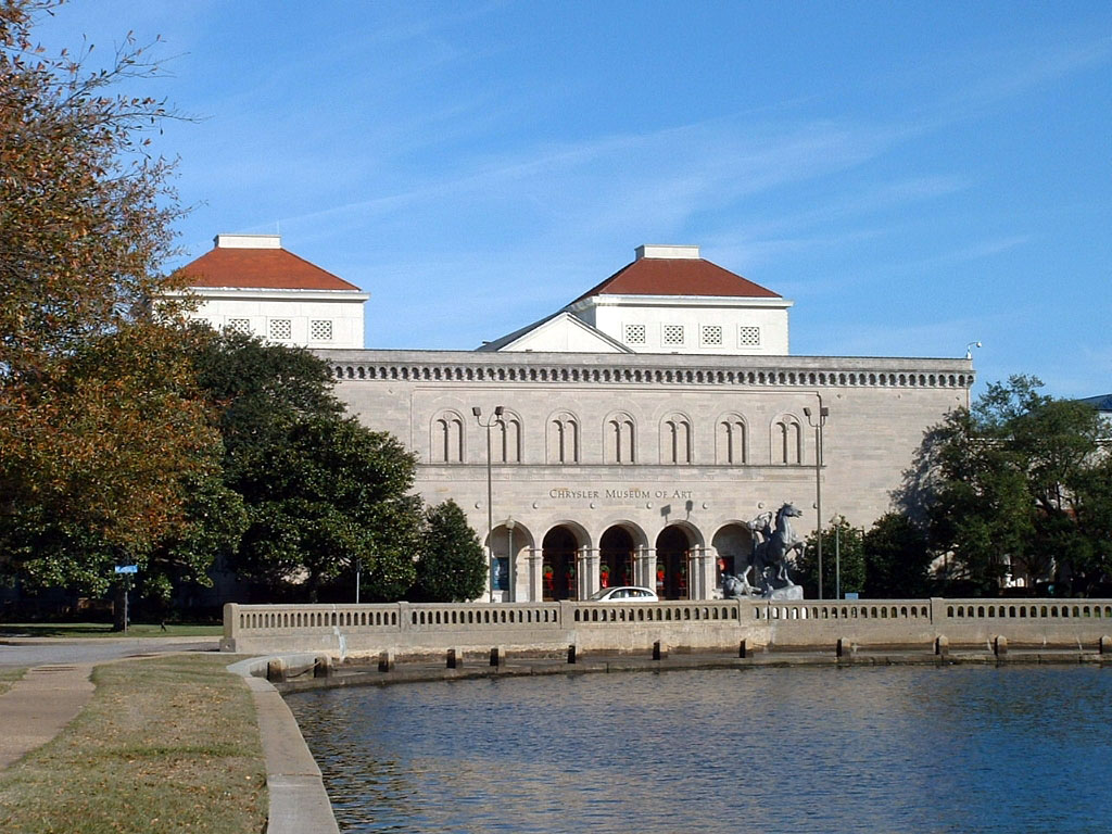
Chrysler Museum of Art
Museum · 3.9 mi
Art museum in Norfolk, Virginia
1 Memorial Place, Norfolk
Tu-Sa 10:00-17:00; Su 12:00-17:00


Fort Norfolk
Monument and historic site · National Register of Historic Places · 3.1 mi
Fort in Norfolk, Virginia
801 Front Street, Norfolk

Park View Historic District
Monument and historic site · National Register of Historic Places · 3.2 mi
Historic district in Virginia, United States

Port Norfolk Historic District
Monument and historic site · National Register of Historic Places · 1.8 mi
Historic district in Virginia, United States
Allmand-Archer House
Monument and historic site · National Register of Historic Places · 3.9 mi
United States historic place
American Cigar Company
Monument and historic site · National Register of Historic Places · 5.1 mi
Two historic cigar factory buildings located at Norfolk, Virginia

Attucks Theatre
Monument and historic site · National Register of Historic Places · 4.6 mi
Theater and movie theater in Norfolk, Virginia, United States
Basilica of Saint Mary of the Immaculate Conception, Norfolk
Monument and historic site · National Register of Historic Places · 4.6 mi
Church building in Norfolk, United States of America

Berkley
Monument and historic site · National Register of Historic Places · 4.9 mi
Unincorporated community in Virginia

Boush-Tazewell House
Monument and historic site · National Register of Historic Places · 3.6 mi
Historic house in Virginia, United States


Cedar Grove Cemetery
Monument and historic site · National Register of Historic Places · 3.5 mi
Cemetery in Portsmouth, Virginia, United States
75 more on the map.
Parks, trails and playgrounds63

Elizabeth Manor Golf & Country Club
Golf course · 3.8 mi
1 Ace Parker Drive, Portsmouth
Tu-Su 07:00-17:00


Chartway Arena at the Ted Constant Convocation Center
Sports field and stadium · 3.7 mi
4320 Hampton Boulevard, Norfolk

51 more on the map.
Restaurants and cafes232

Bangkok Garden
Restaurant · Thai · 1.6 mi
5774 Churchland Boulevard, Portsmouth
Mo-Fr 11:00-21:00; Sa-Su 12:00-21:00
Billy D's Seafood & Chicken
Restaurant · Chicken, Seafood · 1.6 mi
3205 Stamford Road, Portsmouth
Tu-Th 11:30-19:00; Fr,Sa 11:30-20:00; Su 12:00-18:00
Biscuit Belly
Restaurant · American, Regional · 3.4 mi
2401 Hampton Boulevard, Norfolk
Mo-Th 07:30-14:00; Fr-Su 07:30-15:00
California Burrito
Restaurant · Mexican · 3.7 mi
2860 Airline Boulevard, Portsmouth
Mo 11:00-20:00; Tu,Th 11:00-21:00; We 11:00-22:00; Fr 11:00-01:30;...
Domoishi
Restaurant · Asian, Poke, Ramen · 3.6 mi
6216 College Drive, Suffolk
Mo-Th 11:00-21:00; Fr-Sa 11:00-22:00; Su 12:00-21:00
High Street Pizza & Pour House
Restaurant · Pizza · 3.9 mi
501 High Street, Portsmouth
Mo-Th 17:00-22:00; Fr-Su 11:00-22:00
IHOP
Restaurant · Breakfast, Pancake · 3.5 mi
6200 College Drive, Suffolk
Mo-Th,Su 07:00-22:00; Fr,Sa 07:00-24:00

Starbucks
Cafe · Coffee Shop · 3.6 mi
361 Effingham Street, Portsmouth
Mo-Fr 04:30-20:00; Sa 06:00-18:30; Su 06:00-19:00

Yummy Wok
Restaurant · Chinese · 3.6 mi
811 Brandon Avenue, Norfolk
Mo 11:00-22:15; We-Th 11:00-22:15; Fr-Sa 11:00-22:45; Su 12:00-21:45
220 more on the map.
Where to stay9
SpringHill Suites Norfolk Old Dominion University
Motel and hotel · 3.6 mi
4500 Hampton Boulevard, Norfolk
Extended Stay America
Motel and hotel · 2.6 mi
3214 Churchland Boulevard, Chesapeake
Riverwalk Inn & Suites Portsmouth
Motel and hotel · 3.5 mi
333 Effingham Street, Portsmouth
Super Value Inn Ports Mouth/Olde Town Area
Motel and hotel · 3.5 mi
925 London Boulevard, Portsmouth
Churches and places of worship113
Monumental United Methodist Church
Church · United Methodist · 3.8 mi
450 Dinwiddie Street, Portsmouth
Saint Pauls Catholic Church
Church · Roman Catholic · 3.8 mi
522 High Street, Portsmouth
Olive Branch Baptist Church
Church · Baptist · 3.6 mi
2608 Airline Boulevard, Portsmouth
Alexander Baptist Church
Church · Baptist · 3.3 mi
3915 Turnpike Road, Portsmouth
Biltmore Baptist Church
Church · Baptist · 3.8 mi
3214 Elliott Avenue, Portsmouth
Shopping43
Gas and EV charging32
Schools, colleges and libraries85
Berkley/Campostella Early Childhood Education Center
School · 5.9 mi
1530 Cypress St, Norfolk
Healthcare25
Fresenius Kidney Care
Clinic and pharmacy · 3.8 mi
3080 Airline Boulevard, Portsmouth
Map of Portsmouth
250 places. The map loads OpenStreetMap tiles when you open it.
Climate by month
Monthly table
| Month | High | Low | Rain | Snow |
|---|---|---|---|---|
| Jan | 50°F | 34°F | 2.9 in | 2.3 in |
| Feb | 53°F | 35°F | 2.5 in | 0.7 in |
| Mar | 59°F | 41°F | 3.5 in | 0.0 in |
| Apr | 70°F | 50°F | 3.3 in | 0.0 in |
| May | 77°F | 60°F | 3.5 in | 0.0 in |
| Jun | 84°F | 68°F | 4.6 in | 0.0 in |
| Jul | 89°F | 73°F | 5.2 in | 0.0 in |
| Aug | 86°F | 72°F | 5.3 in | 0.0 in |
| Sep | 81°F | 67°F | 5.1 in | 0.0 in |
| Oct | 72°F | 56°F | 3.6 in | 0.0 in |
| Nov | 61°F | 45°F | 3.1 in | 0.0 in |
| Dec | 54°F | 38°F | 2.9 in | 0.0 in |
U.S. Climate Normals 1991-2020 for Norfolk Nas (7 mi away), NOAA NCEI.
People and cost of living
American Community Survey 5-year estimates, 2020-2024, U.S. Census Bureau. Estimates have margins of error, larger for small towns.
Disaster history
Portsmouth city has had 11 federal disaster declarations since 2000, most often for hurricanes.
- 2026-01-23: Severe Winter Storm (Winter Storm)
- 2020-04-02: Covid-19 Pandemic (Biological)
- 2020-03-13: Covid-19 (Biological)
- 2018-09-11: Hurricane Florence (Hurricane)
- 2016-11-02: Hurricane Matthew (Hurricane)
- 2012-10-29: Hurricane Sandy (Hurricane)
OpenFEMA disaster declarations summaries.
Getting there and nearby towns
Norfolk Naval Station (Chambers Field) (NGU) is the nearest airport with scheduled flights listed in OpenStreetMap, 6 miles away.
- Norfolk 8 mi northeast, about 12 min by car
- Carrollton 10 mi northwest, about 16 min by car
- Chesapeake 13 mi south, about 21 min by car
- Hampton 13 mi north, about 21 min by car
- Benns Church 13 mi west, about 21 min by car
- Newport News 17 mi northwest, about 28 min by car
- Virginia Beach 19 mi east, about 31 min by car
- Poquoson 19 mi north, about 30 min by car
- Gloucester Point 29 mi north, about 47 min by car
- Elizabeth City 40 mi south, about 1 h by car
Drive times are estimates from straight-line distance, not routes.
Local news
Headlines from INDB, the NEMICO news database.
Reviews, tips and questions
Loading what members have shared...
Sources and licences
- NCES EDGE (Public domain): public schools
- NOAA NCEI U.S. Climate Normals 1991-2020 (Public domain): climate by month
- OpenFEMA (Public domain): disaster declarations
- OpenStreetMap contributors (ODbL 1.0): places, airports, map data
- U.S. Census Bureau (Public domain): population, income, housing, education, commute
- Wikidata (CC0 1.0): elevation, founding date, time zone, website, landmarks and historic places
- Wikimedia Commons (see each image): photos
- Wikipedia (CC BY-SA 4.0): overview and history text
Photo credits
- US Navy 030820-N-9851B-011 Tug boats guide USS Harry S. Truman (CVN 75) up the Elizabeth River, past Portsmouth landmarks, U.S. Navy photo, Public domain
- 2017-07-13 12 46 35 View west along Virginia State Route 164 (Western Freeway) just east of Virginia International Gateway Boulevard in Portsmouth, Virginia, Famartin, CC BY-SA 4.0
- Former site of The Circle Restaurant in Portsmouth VA 18SEP2014, Capt1922, CC BY-SA 3.0
- Chryslermuseum, Gosscj at English Wikipedia, Public domain
- Portsmouth, Virginia (8596809033), Doug Kerr from Albany, NY, United States, CC BY-SA 2.0
- Plan of Fort Norfolk 1860, Charles E. Cassell, Public domain
- Park View Historic District, Crawford St Entrance 12SEP2014, Capt1922, CC BY-SA 3.0
- Zion Methodist Church in Norfolk, Nyttend, Public domain
- BOUSH-TAZEWELL HOUSE, NORFOLK, VA, JERRYE & ROY KLOTZ. M.D., CC BY-SA 4.0
- Stockley Gardens, North Ghent, Nyttend, Public domain
- Portsmouth, Virginia (8596813145) (3), Doug Kerr from Albany, NY, United States, CC BY-SA 2.0
- St. John's African Methodist Episcopal Church, Cathy1763, CC BY-SA 3.0
- Sunray School (1922), James Shelton32, CC BY-SA 4.0
- Willoughby-Baylor House, Cathy1763, CC BY-SA 3.0
- East Berkley Avenue (Norfolk), Jmarian7, CC BY-SA 3.0
- A Light Named Portsmouth, William J. Grimes, Public domain
- United States Post Office and Courthouse (1934), Norfolk city, Virginia, Unknown author Unknown author, Public domain
- USS Wisconsin (BB-64) underway at sea, circa 1988-1991 (NH 97206-KN), Unknown author Unknown author, Public domain
- PostcardNorfolkVACustomHouseCirca1900, Unknown author Unknown author, Public domain
- Norfolk's Freemason Historic District at Sunset, Lluck002, CC BY-SA 4.0
- Attucks Theatre, Cathy1763, CC BY-SA 3.0
- Portsmouth, Virginia (8596805587), Doug Kerr from Albany, NY, United States, CC BY-SA 2.0
- PORTSMOUTH OLDE TOWNE HISTORIC DISTRICT, PORTSMOUTH, VA, JERRYE & ROY KLOTZ, M.D., CC BY-SA 4.0
- St. Paul's Catholic Church, Porsmouth VA 12SEP2014, Capt1922, CC BY-SA 3.0
- Portsmouth, Virginia (8596812341), Doug Kerr from Albany, NY, United States, CC BY-SA 2.0
- Portsmouth Community Library 13SEP2014, Capt1922, CC BY-SA 3.0
- Monticello Arcade interior, ca 1986 CROPPED, JGKlein, Public domain
- Queen Street Baptist Church, Amandajollota, CC BY-SA 3.0
- Cedar Grove Cemetery 13Sep2014, Capt1922, CC BY-SA 3.0
- Taylor-Whittle House, Cathy1763, CC BY-SA 3.0
- First Calvary Baptist Church, Cathy1763, CC BY-SA 3.0
- Stewart Street, South Norfolk, Nyttend, Public domain
- C&SL-Norfolk, Kurt Taylor Gaubatz, CC BY-SA 3.0
- Portsmouth, Virginia (8597911744), Doug Kerr from Albany, NY, United States, CC BY-SA 2.0
- Virginia Bank and Trust Building, Cathy1763, CC BY-SA 3.0
- Brown Avenue in Norfolk, St. Peter's Episcopal Church, Nyttend, Public domain
- First Baptist Church, Norfolk, VA, Cathy1763, CC BY-SA 3.0
- PortsmouthNavalAsylum, unidentified HABS photographer, Public domain
- U.S. Post Office & Federal Courts Building, 235 East Plume Street (Norfolk city, Virginia), Charles Ansell, Photographer, Public domain
- Truxton, Portsmouth west of Dahlia, Nyttend, Public domain


Page built October 30, 2026. Spotted a mistake? Tell us or suggest a place.