




Prospect, Kentucky
Prospect is a city of 4,542 people in Jefferson County, Kentucky, founded in 1974.
Why visit Prospect
Townapedia lists 5 museums and landmarks, 3 parks and trails, 16 places to eat and 1 attraction in and around town.
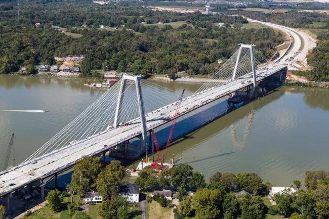
Highlights include Lewis and Clark Bridge, Rogers Clark Ballard Memorial School, Von Allmen Dairy Farm House and Hunting Creek Golf Course.
July is the warmest month, with average highs of 88°F; January lows average 27°F.
Weather in Prospect
Forecast from the National Weather Service. Full forecast
About Prospect
Prospect is a home rule-class city in Jefferson and Oldham counties in the U.S. state of Kentucky. The Jefferson County portion is a part of the Louisville Metro government. The population was 4,592 as of the 2020 census, down from 4,698 at the time of the 2010 census. It is one of the wealthiest communities in Kentucky.
From the Wikipedia article Prospect, Kentucky (this version), under CC BY-SA 4.0.
Things to do1
Museums and landmarks5

Rogers Clark Ballard Memorial School
Monument and historic site · National Register of Historic Places · 3.1 mi
School building in Louisville, United States of America

Von Allmen Dairy Farm House
Monument and historic site · National Register of Historic Places · 3.0 mi
House in Louisville, United States of America

Merriweather House
Monument and historic site · 1.8 mi
6421 River Road, Louisville
Wolf Pen Branch Mill
Monument and historic site · 1.5 mi
Wolf Pen Branch Road, Louisville
Parks, trails and playgrounds3




Restaurants and cafes16

Gracious Plenty
Restaurant · Sandwich, American, Bakery · 0.7 mi
9207 US-42, Prospect
Mo-Fr 10:00-20:00; Sa-Su 08:00-14:00

Cunningham's Creekside
Restaurant · American, Seafood · 2.0 mi
6301 River Road, Louisville


DQ Grill & Chill
Fast food · Ice Cream, Burger · 0.6 mi
9515 U S Highway 42, Prospect
Mo-Sa 06:00-23:00; Su 07:00-23:00
4 more on the map.
History
The area was first known as "Sand Hill" when it was settled by farmers in the late 18th century. The present community grew up around the "Prospect" railroad station erected by the Louisville, Harrods Creek and Westport Railway c. 1872. The name referred either to the view from the top of the hill or the expected completion of the line (which – owing to the Long Depression – never did reach Westport and collapsed into bankruptcy in 1879). When the post office was established in 1886, the local postmaster named it "Wilhoyte" in his own honor, but the community corrected this within the month.
Although a few luxury residences existed in the area from the late 19th century and the Louisville Railway Company offered hourly electrified-rail trolleys along the former LHC&W line after 1904, it was largely agricultural until the mid-1960s when large-scale high-end subdivisions were built in the area, most notably the Estates of Hunting Creek, which included a golf course. The newest large-scale high-end development, covering almost 600-acres, is Norton Commons.
An EF2 tornado struck the town on April 2, 2024, causing major damage.
From the History section of Prospect, Kentucky on Wikipedia, under CC BY-SA 4.0.
Churches and places of worship3
Shopping3
Gas and EV charging3
Schools, colleges and libraries21
Goshen At Hillcrest Elementary School
School · 2.0 mi
12518 Ridgemoor Dr, Prospect
Healthcare1
Map of Prospect
56 places. The map loads OpenStreetMap tiles when you open it.
Climate by month
Monthly table
| Month | High | Low | Rain |
|---|---|---|---|
| Jan | 43°F | 27°F | 3.3 in |
| Feb | 48°F | 30°F | 3.3 in |
| Mar | 57°F | 38°F | 4.4 in |
| Apr | 69°F | 48°F | 4.7 in |
| May | 77°F | 57°F | 5.2 in |
| Jun | 85°F | 66°F | 4.7 in |
| Jul | 88°F | 69°F | 4.6 in |
| Aug | 87°F | 68°F | 3.5 in |
| Sep | 81°F | 60°F | 3.6 in |
| Oct | 69°F | 48°F | 3.6 in |
| Nov | 57°F | 38°F | 3.4 in |
| Dec | 46°F | 31°F | 3.9 in |
U.S. Climate Normals 1991-2020 for Louisville Bowman Fld (9 mi away), NOAA NCEI.
People and cost of living
American Community Survey 5-year estimates, 2020-2024, U.S. Census Bureau. Estimates have margins of error, larger for small towns.
Disaster history
Jefferson County has had 19 federal disaster declarations since 2000, most often for severe storms.
- 2026-01-24: Severe Winter Storm (Winter Storm)
- 2025-04-24: Severe Storms, Straight-Line Winds, Tornadoes, Flooding, Landslides, And Mudslides (Severe Storm)
- 2025-04-03: Severe Storms, Straight-Line Winds, Tornadoes, And Flooding (Severe Storm)
- 2025-02-24: Severe Storms, Straight-Line Winds, Flooding, Landslides, And Mudslides (Severe Storm)
- 2025-02-16: Severe Storms, Straight-Line Winds, Flooding, And Landslides (Severe Storm)
- 2024-05-22: Severe Storms, Straight-Line Winds, Tornadoes, Landslides, And Mudslides (Severe Storm)
OpenFEMA disaster declarations summaries.
Getting there and nearby towns
Bowman Field (LOU) is the nearest airport with scheduled flights listed in OpenStreetMap, 9 miles away.
- Utica 3 mi west, about 4 min by car
- Barbourmeade 3 mi south, about 5 min by car
- Northfield 4 mi south, about 7 min by car
- Plantation 4 mi south, about 7 min by car
- Jeffersonville 5 mi west, about 8 min by car
- Orchard Grass Hills 5 mi east, about 8 min by car
- Graymoor-Devondale 5 mi south, about 8 min by car
- Indian Hills 5 mi southwest, about 8 min by car
- Coldstream 5 mi southeast, about 8 min by car
- Lyndon 6 mi south, about 10 min by car
Drive times are estimates from straight-line distance, not routes.
Local news
Headlines from INDB, the NEMICO news database.
Reviews, tips and questions
Loading what members have shared...
Sources and licences
- NCES EDGE (Public domain): public schools
- NOAA NCEI U.S. Climate Normals 1991-2020 (Public domain): climate by month
- OpenFEMA (Public domain): disaster declarations
- OpenStreetMap contributors (ODbL 1.0): places, airports, map data
- U.S. Census Bureau (Public domain): population, income, housing, education, commute
- Wikidata (CC0 1.0): elevation, founding date, time zone, website, landmarks and historic places
- Wikimedia Commons (see each image): photos
- Wikipedia (CC BY-SA 4.0): overview and history text
Photo credits
- Jefferson Jacob School, Nyttend, Public domain
- Von Allmen Dairy Farm House, Nyttend, Public domain
- Rogers Clark Ballard Memorial School, Nyttend, Public domain
- Lewis & Clark Bridge in Louisville, Kentucky, National Park Service (individual author not shown), Public domain
- James Trigg House, Nyttend, Public domain
- Wilhoyte House, Nyttend, Public domain
- Fincastle estate, Nyttend, Public domain
- Spizella passerina - wilderbombyx - 622149696, wilderbombyx, CC0
- A4h015 2mp Garvin Brown Preserve (6366276425), William Alden from Louisville, Kentucky, USA, CC BY-SA 2.0
- A4h014 2mp Garvin Brown Preserve (6366274377), William Alden from Louisville, Kentucky, USA, CC BY-SA 2.0
- A5i021 9mp view upriver from Garvin Brown Preserve (6421827159), William Alden from Louisville, Kentucky, USA, CC BY-SA 2.0
- A5i022 9mp view downriver from Garvin Brown Preserve (6421837217), William Alden from Louisville, Kentucky, USA, CC BY-SA 2.0
- Barber-Barbour House, Nyttend, Public domain
- Lane up to Belleview, Nyttend, Public domain
- Merriwether House, Nyttend, Public domain
- Drive up to Drumenard, Nyttend, Public domain
- Nitta Yuma Drive, Nyttend, Public domain
- Allison-Barrickman House, Nyttend, Public domain
- Ashbourne drive, Nyttend, Public domain
- Harrods Creek fields, Nyttend, Public domain
- Lewis and Clark Bridge 2025b, Antony-22, CC BY-SA 4.0
- 88c130 Gap in cliffs at abandoned quarry near Utica, Indiana (27804585482), William Alden from Louisville, Kentucky, USA, CC BY-SA 2.0
- Lewis and Clark Bridge 2025a, Antony-22, CC BY-SA 4.0
- 88b063 Harrods Creek Boat Harbor ramp and docks (15925897782), William Alden from Louisville, Kentucky, USA, CC BY-SA 2.0


Page built October 30, 2026. Spotted a mistake? Tell us or suggest a place.