



Why visit Utica
Townapedia lists 7 museums and landmarks, 3 parks and trails, 6 places to eat and 1 attraction in and around town.
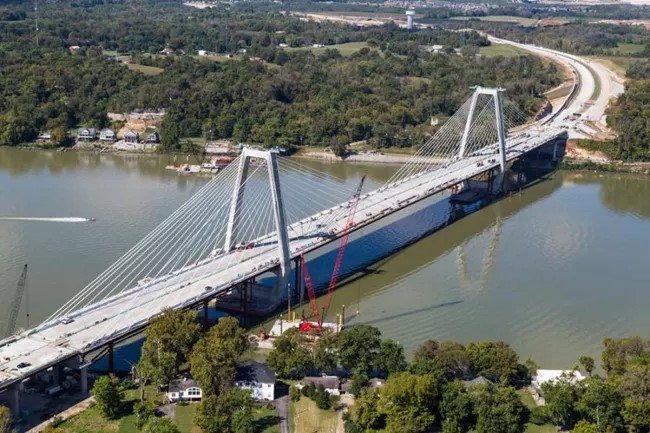
Highlights include Lewis and Clark Bridge, Boxhill and Lincliff.
July is the warmest month, with average highs of 88°F; January lows average 27°F.
Weather in Utica
Forecast from the National Weather Service. Full forecast
About Utica
Utica is a town in Utica Township, Clark County, Indiana, United States. It lies adjacent to major infrastructure: the Interstate 265 bridge across the Ohio (opened in 2016), the nearby Port of Indiana – Jeffersonville, and the River Ridge Commerce Center. These developments shape its land-use environment and limit the town's potential for large-scale growth.
From the Wikipedia article Utica, Indiana (this version), under CC BY-SA 4.0.
Things to do1
Museums and landmarks7

Boxhill
Monument and historic site · National Register of Historic Places · 2.6 mi
House in Glenview, Kentucky

Lincliff
Monument and historic site · National Register of Historic Places · 3.0 mi
Historic house in Kentucky, United States

Midlands
Monument and historic site · National Register of Historic Places · 3.3 mi
Building in Kentucky, United States

Rogers Clark Ballard Memorial School
Monument and historic site · National Register of Historic Places · 1.9 mi
School building in Louisville, United States of America


Prather Site
Monument and historic site · 3.4 mi
Archaeological site in Indiana, United States

Parks, trails and playgrounds3


Restaurants and cafes6

Cunningham's Creekside
Restaurant · American, Seafood · 1.3 mi
6301 River Road, Louisville


History
From 1794 to 1825, Utica served as a key ferry crossing of the Ohio River. Its location provided a safer alternative to the river crossings at Jeffersonville, where the nearby Falls of the Ohio presented navigational hazards.
James Noble Wood was the first ferryman and founder of Utica. In 1801 he was appointed by Governor W. H. Harrison as one of the justices of the court of general quarter of Clarke of the Territory of Indiana at Springville, Indiana.
Daniel Guernsey, migrated with his family from Connecticut to Clark County in 1817. The Guernsey family traveled by flatboat from Olean Point to their landing near Utica. After a year's farming in the township, Guernsey purchased 200 acres near Blue Lick, Indiana, where the family remained for decades. He graduated from Yale, and was the first school teacher in Monroe County.
In 1997, the town experienced significant flooding. In response, local officials strengthened building, planning and zoning regulations as a condition of receiving federal and state disaster-recovery assistance.
From the History section of Utica, Indiana on Wikipedia, under CC BY-SA 4.0.
Churches and places of worship3
Schools, colleges and libraries25
Goshen At Hillcrest Elementary School
School · 4.2 mi
12518 Ridgemoor Dr, Prospect
Greater Clark County Schools Virtual Academy
School · 3.6 mi
2710 E 10Th St, Jeffersonville
Map of Utica
45 places. The map loads OpenStreetMap tiles when you open it.
Climate by month
Monthly table
| Month | High | Low | Rain |
|---|---|---|---|
| Jan | 43°F | 27°F | 3.3 in |
| Feb | 48°F | 30°F | 3.3 in |
| Mar | 57°F | 38°F | 4.4 in |
| Apr | 69°F | 48°F | 4.7 in |
| May | 77°F | 57°F | 5.2 in |
| Jun | 85°F | 66°F | 4.7 in |
| Jul | 88°F | 69°F | 4.6 in |
| Aug | 87°F | 68°F | 3.5 in |
| Sep | 81°F | 60°F | 3.6 in |
| Oct | 69°F | 48°F | 3.6 in |
| Nov | 57°F | 38°F | 3.4 in |
| Dec | 46°F | 31°F | 3.9 in |
U.S. Climate Normals 1991-2020 for Louisville Bowman Fld (8 mi away), NOAA NCEI.
People and cost of living
American Community Survey 5-year estimates, 2020-2024, U.S. Census Bureau. Estimates have margins of error, larger for small towns.
Disaster history
Clark County has had 14 federal disaster declarations since 2000, most often for severe storms.
- 2026-01-24: Severe Winter Storm (Winter Storm)
- 2025-07-22: Severe Storms, Straight-Line Winds, Tornadoes, And Flooding (Flood)
- 2020-04-03: Covid-19 Pandemic (Biological)
- 2020-03-13: Covid-19 (Biological)
- 2018-05-04: Severe Storms And Flooding (Flood)
- 2012-03-09: Severe Storms, Straight-Line Winds, And Tornadoes (Severe Storm)
OpenFEMA disaster declarations summaries.
Getting there and nearby towns
Bowman Field (LOU) is the nearest airport with scheduled flights listed in OpenStreetMap, 7 miles away.
- Jeffersonville 2 mi west, about 4 min by car
- Clarksville 6 mi west, about 10 min by car
- St. Matthews 6 mi south, about 10 min by car
- Lyndon 6 mi southeast, about 10 min by car
- Sellersburg 8 mi northwest, about 12 min by car
- New Albany 9 mi west, about 15 min by car
- Jeffersontown 10 mi southeast, about 17 min by car
- Louisville/Jefferson County 12 mi south, about 19 min by car
- Shively 13 mi southwest, about 21 min by car
- La Grange 16 mi east, about 25 min by car
Drive times are estimates from straight-line distance, not routes.
Local news
Headlines from INDB, the NEMICO news database.
Reviews, tips and questions
Loading what members have shared...
Sources and licences
- NCES EDGE (Public domain): public schools
- NOAA NCEI U.S. Climate Normals 1991-2020 (Public domain): climate by month
- OpenFEMA (Public domain): disaster declarations
- OpenStreetMap contributors (ODbL 1.0): places, airports, map data
- U.S. Census Bureau (Public domain): population, income, housing, education, commute
- Wikidata (CC0 1.0): elevation, founding date, time zone, website, landmarks and historic places
- Wikimedia Commons (see each image): photos
- Wikipedia (CC BY-SA 4.0): overview and history text
Photo credits
- Midlands, Louisville, Nyttend, Public domain
- Rogers Clark Ballard Memorial School, Nyttend, Public domain
- Lincliff gates, Nyttend, Public domain
- Winkworth, Boxhill, in Louisville, Nyttend, Public domain
- Lewis & Clark Bridge in Louisville, Kentucky, National Park Service (individual author not shown), Public domain
- Prather Site from Charlestown Pike, Nyttend, Public domain
Page built October 30, 2026. Spotted a mistake? Tell us or suggest a place.