


Provincetown, Massachusetts
Provincetown is a community of 3,452 people in Barnstable County, Massachusetts.
Why visit Provincetown
Townapedia lists 63 museums and landmarks, 30 parks and trails, 87 places to eat, 57 places to stay and 11 attractions in and around town.
Highlights include Long Point Light, Wood End Light, Pilgrim Monument and Provincetown Public Library.
Weather in Provincetown
Forecast from the National Weather Service. Full forecast
About Provincetown
Provincetown (CDP) is a census-designated place (CDP) in the town of Provincetown in Barnstable County, Massachusetts, United States. The population was 2,642 at the 2010 census, out of 2,942 in the entire town.
From the Wikipedia article Provincetown (CDP), Massachusetts (this version), under CC BY-SA 4.0.
Things to do11

Long Point Light
Lighthouse · National Register of Historic Places · 1.8 mi
Lighthouse in Massachusetts, United States
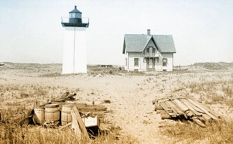
Wood End Light
Lighthouse · National Register of Historic Places · 2.9 mi
Lighthouse in Massachusetts, United States


Museums and landmarks63

Pilgrim Monument
Monument and historic site · 1.1 mi
Monument in Provincetown, Massachusetts, USA
1 High Pole Hill Road, Provincetown

Provincetown Public Library
Monument and historic site · National Register of Historic Places · 0.9 mi
Historic building in Provincetown, Massachusetts, United States
356 Commercial Street, Provincetown
Dune Shacks of Peaked Hill Bars Historic District
Monument and historic site · National Register of Historic Places · 0.4 mi
Historic district in Provincetown and Truro, Massachusetts
Hawthorne Class Studio
Monument and historic site · National Register of Historic Places · 0.6 mi
Historic studio building in Provincetown, Massachusetts, United States

Old Harbor U.S. Life Saving Station
Monument and historic site · National Register of Historic Places · 2.7 mi
Historic maritime rescue station and museum

Provincetown Art Association & Museum;Provincetown Art Association and Museum
Museum · 0.5 mi
460 Commercial Street, Provincetown

Provincetown Historic District
Monument and historic site · National Register of Historic Places · 1.1 mi
O portion of downtown Provincetown that is listed in the National Register of Historic Places

United States Post Office
Monument and historic site · National Register of Historic Places · 1.2 mi
Government building in Provincetown, Massachusetts
51 more on the map.
Parks, trails and playgrounds30






18 more on the map.
Restaurants and cafes87


Blue Monkey Cafe
Cafe · 0.9 mi
334 Commercial Street, Provincetown
Mo-Th off; Fr 10:00-15:00; Sa,Su 09:00-16:00
French Patisserie Cafe Provincetown
Cafe · Coffee Shop, Pastry · 0.8 mi
353 Commercial Street, Provincetown


Provincetown Brewing Co.
Bar and pub · 0.9 mi
141 Bradford Street, Provincetown
Mo-Sa 09:00-23:00; Su 09:00-22:00
361 Coffee & Espresso Bar
Cafe · Coffee · 0.8 mi
361 Commercial Street, Provincetown
Su-Th 06:30-22:00; Fr,Sa 06:30-23:00
Brewhouse 1620
Restaurant · Burger · 1.2 mi
214 Commercial Street
Mo-Su 11:25-21:45
75 more on the map.
Where to stay57
Churches and places of worship6
Center Methodist Church
Church · National Register of Historic Places · 0.8 mi
First Universalist Church
Church · National Register of Historic Places · 1.1 mi
Unitarian Universalist Meeting House of Provincetown
Place of worship · 1.1 mi
236 Commercial Street, Provincetown
The Church of Saint Mary of the Harbor
Church · Episcopal
517 Commercial Street, Provincetown
Shopping27
Gas and EV charging4
Schools, colleges and libraries2
Healthcare4
Map of Provincetown
250 places. The map loads OpenStreetMap tiles when you open it.
People and cost of living
American Community Survey 5-year estimates, 2020-2024, U.S. Census Bureau. Estimates have margins of error, larger for small towns.
Disaster history
Barnstable County has had 16 federal disaster declarations since 2000, most often for hurricanes.
- 2023-09-15: Hurricane Lee (Hurricane)
- 2020-03-27: Covid-19 Pandemic (Biological)
- 2020-03-13: Covid-19 (Biological)
- 2018-06-25: Severe Winter Storm And Flooding (Severe Storm)
- 2015-04-13: Severe Winter Storm, Snowstorm, And Flooding (Severe Storm)
- 2013-04-19: Severe Winter Storm, Snowstorm, And Flooding (Severe Storm)
OpenFEMA disaster declarations summaries.
Getting there and nearby towns
Provincetown Municipal Airport (PVC) is the nearest airport with scheduled flights listed in OpenStreetMap, 2 miles away.
- North Eastham 17 mi southeast, about 27 min by car
- Orleans 21 mi southeast, about 33 min by car
- Brewster 21 mi south, about 34 min by car
- East Dennis 22 mi south, about 36 min by car
- Dennis 23 mi south, about 37 min by car
- Green Harbor 25 mi west, about 39 min by car
- Cedar Crest 25 mi west, about 41 min by car
- Duxbury 26 mi west, about 42 min by car
- South Yarmouth 27 mi south, about 44 min by car
- Barnstable Town 29 mi south, about 47 min by car
Drive times are estimates from straight-line distance, not routes.
Local news
Headlines from INDB, the NEMICO news database.
Reviews, tips and questions
Loading what members have shared...
Sources and licences
- NCES EDGE (Public domain): public schools
- OpenFEMA (Public domain): disaster declarations
- OpenStreetMap contributors (ODbL 1.0): places, airports, map data
- U.S. Census Bureau (Public domain): population, income, housing, education, commute
- Wikidata (CC0 1.0): elevation, founding date, time zone, website, landmarks and historic places
- Wikimedia Commons (see each image): photos
- Wikipedia (CC BY-SA 4.0): overview and history text
Photo credits
- View of Provincetown from Pilgrim Monument looking east, MA, John Phelan, CC BY 3.0
- String Deep Fried Onion Rings at Fanizzi's, Provincetown (29500017862), Carlos Pacheco from Toronto, Canada, CC BY 2.0
- Old Colony Nature Pathway, 2, Provincetown MA, John Phelan, CC BY-SA 4.0
- Provincetown Harbour, Massachusetts (493679) (11110052664), Robert Linsdell from St. Andrews, Canada, CC BY 2.0
- Provincetown Jetty in Provincetown, Massachusetts, Griffinrocco1, CC BY-SA 4.0
- Provincetown, United States (Unsplash), Thomas Kelley thkelley, CC0
- Letter box in Provincetown, MA, USA, Le grand Cricri, CC BY-SA 3.0
- Donald Baxter MacMillan House, Provincetown, MA, USA Sep 2013, User:WestportWiki, CC BY-SA 3.0
- Old Colony Nature Pathway, Provincetown MA, John Phelan, CC BY-SA 4.0
- Provincetown Harbour, Massachusetts (493680) (11110064256), Robert Linsdell from St. Andrews, Canada, CC BY 2.0
- Provincetown, MA, USA - panoramio (52), bynyalcin, CC BY 3.0
- Provincetown, MA, USA - panoramio (53), bynyalcin, CC BY 3.0
- Provincetown, MA, USA - panoramio (51), bynyalcin, CC BY 3.0
- Provincetown, MA, USA - panoramio (55), bynyalcin, CC BY 3.0
- Provincetown, MA, USA - panoramio - ingawh (1), ingawh, CC BY-SA 3.0
- Provincetown Harbour, Massachusetts (493681) (11110196653), Robert Linsdell from St. Andrews, Canada, CC BY 2.0
- Provincetown, MA, USA - panoramio (50), bynyalcin, CC BY 3.0
- Provincetown, MA, USA - panoramio (54), bynyalcin, CC BY 3.0
- Fine Arts Work Center, Provincetown, Massachusetts, CastIronSeasoner, CC BY 4.0
- PilgrimMonumentbasrelief, Peter Whitlock (Transferred by adavyd /Originally uploaded by Willster3 ), CC BY-SA 3.0
- Long Point Light Station, Meatba11, CC BY-SA 3.0
- Wood End Lighthouse MA, US Coast Guard, Public domain
- 1stUniversalist Church Provincetown, Peter Whitlock, Public domain
- Ptown post office, Peter Whitlock, Public domain
- Old Harbor Life Saving Station, JCefaly, CC BY-SA 3.0
- Viking Professional Sep 2013, User:WestportWiki, CC BY-SA 3.0
- Phallus rugulosus 296445086, Annie Weissman, CC BY 4.0
- Firehall (8034109340), BriYYZ from Toronto, Canada, CC BY-SA 2.0
- Massachusetts State Route 6A 050706 661, Dougtone, CC BY-SA 2.0
- Massachusetts State Route 6A 050706 662, Dougtone, CC BY-SA 2.0
- Driving through Cape Cod National Seashore (14097678143), m01229 from USA, CC BY 2.0
- Massachusetts State Route 6A 050706 663, Dougtone, CC BY-SA 2.0
- A perfect cottage (8034108770), BriYYZ from Toronto, Canada, CC BY-SA 2.0
- Massachusetts State Route 6A 050706 664, Dougtone, CC BY-SA 2.0
- Massachusetts State Route 6A 050706 665, Dougtone, CC BY-SA 2.0
- Lucy Cross House, Connor Williams, CC BY 2.0
- Dennis Courtney, Theatrelover777, CC BY-SA 4.0
- Anomia simplex 543709330, Robbie, CC BY 4.0
- Anomia simplex 543709417, Robbie, CC BY 4.0
- Crassostrea virginica 543709316, Robbie, CC BY 4.0


Page built October 30, 2026. Spotted a mistake? Tell us or suggest a place.