


Rensselaer, Indiana
Rensselaer is a city of 5,573 people in Jasper County, Indiana, founded in June 12, 1839.
Why visit Rensselaer
Townapedia lists 16 museums and landmarks, 14 parks and trails, 12 places to eat, 1 place to stay and 4 attractions in and around town.
Highlights include Fountain Stone Theaters, Ritz Cinema, Charles Halleck Student Center and Hugh and Leona Rank House.
July is the warmest month, with average highs of 84°F; January lows average 16°F, and about 25 inches of snow fall in a normal year.
Weather in Rensselaer
Forecast from the National Weather Service. Full forecast
About Rensselaer
Rensselaer is a city located along the Iroquois River in Marion Township, Jasper County, Indiana, United States. The population was 5,733 at the 2020 census, down slightly from 5,859 at the 2010 census. The city is the county seat of Jasper County. Saint Joseph's College is located just south of the city limits.
From the Wikipedia article Rensselaer, Indiana (this version), under CC BY-SA 4.0.
Things to do4

Ritz Cinema
Cinema and theater · 1.0 mi
116 South Van Rensselaer Street, Rensselaer
closed

Rensselaer Farmers Market
Farm and orchard · 1.1 mi
Farmers market runs May - October every year.
Sa 07:30-11:30
Museums and landmarks16

Charles Halleck Student Center
Monument and historic site · National Register of Historic Places · 2.0 mi
Building in Indiana, United States

Hugh and Leona Rank House
Monument and historic site · National Register of Historic Places · 2.6 mi
Building in Indiana, United States
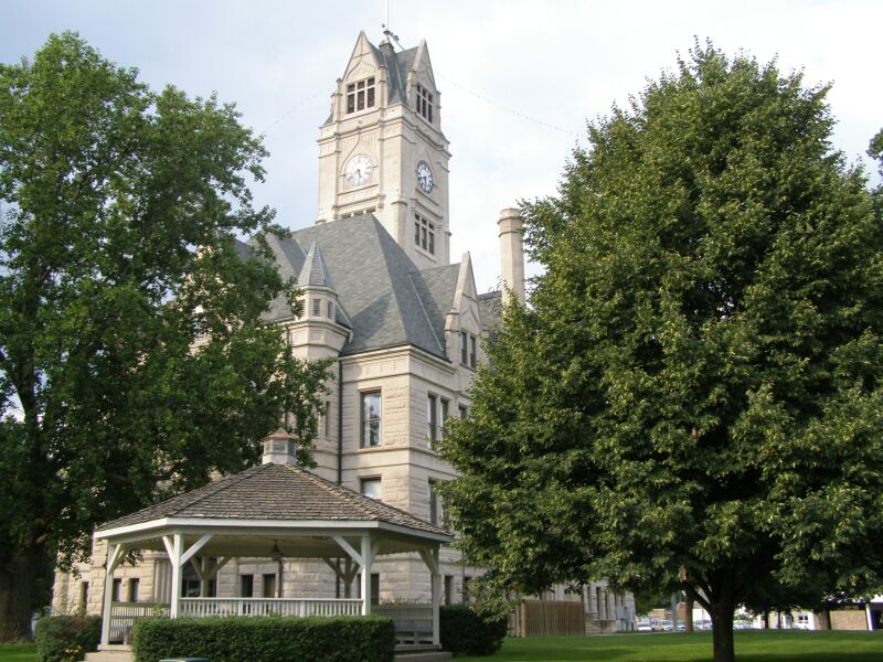
Jasper County Courthouse
Monument and historic site · National Register of Historic Places · 1.0 mi
Courthouse in Indiana, United States
Oren F. and Adelia Parker House
Monument and historic site · National Register of Historic Places · 1.1 mi
Historic house in Indiana, United States

Rensselaer Carnegie Library
Monument and historic site · National Register of Historic Places · 0.9 mi
Carnegie library in Indiana, United States of America
Rensselaer Courthouse Square Historic District
Monument and historic site · National Register of Historic Places · 1.0 mi
Historic district in Indiana, United States
Schwietermann Hall
Monument and historic site · National Register of Historic Places · 2.2 mi
Building in Indiana, United States


St. Joseph Indian Normal School
Monument and historic site · National Register of Historic Places · 2.0 mi

Lilian Fendig Gallery
Museum · 0.9 mi
301 North Van Rensselaer Street, Rensselaer
Tu 12:00-16:00; Th 14:00-18:00
Jasper County Historical Society
Museum · 0.7 mi
479 North Van Rensselaer Street, Rensselaer
4 more on the map.
Parks, trails and playgrounds14

Filson Park
Park · 1.0 mi
This shopping center burned down in 2019. The owner has donated to the city as a public park.
West Kellner Boulevard
Foundation Park
Park · 1.3 mi
A public park on the grounds of the Monet grade school.
Halleck Park
Park · 1.1 mi
Https://rensselaeradventures.blogspot.com/2009/01/halleck-park.html
2 more on the map.
Restaurants and cafes12

eMbers Station Bistro & Bar
Restaurant · Pizza, American · 1.0 mi
230 West Washington Street, Rensselaer
Tu-Sa 11:00-21:00

Cup of Joy Too
Cafe · Coffee Shop, Sandwich, Dessert, Soup, Pastry · 1.0 mi
215 West Washington Street, Rensselaer
Ayda's Mexican Cuisine
Restaurant · Mexican, Bar And Grill · 1.1 mi
208 South Van Rensselaer Street, Rensselaer

Brick Street Ice Cream
Ice cream · 1.1 mi
128 South Van Rensselaer Street, Rensselaer
We-Su 12:00-18:00

La Trinidad Bakery
Bakery · Ice Cream · 1.1 mi
209 West Harrison Street, Rensselaer
Pizza King
Restaurant · Pizza, Chicken, Sandwich · 1.3 mi
227 South College Avenue, Rensselaer
UNOCCUPIED
Restaurant · Mexican, American · 1.0 mi
114 South Van Rensselaer Street, Rensselaer

The Wine Room
Bar and pub · 0.9 mi
128 North Cullen Street, Rensselaer
Fenwick Farms Brew Co
Bar and pub · 1.0 mi
219 West Washington Street, Rensselaer

History
This settlement, first platted on June 12, 1839, was originally named "Newton" and was established at the rapids of the Iroquois River. By 1844, it had been renamed "Rensselaer", after James Van Rensselaer, a merchant from Utica, New York, who came to the area after his business failed in the Panic of 1837. He took over the land from Joseph D. Yeoman, who had established a farm some years earlier and had begun to plan the village.
St. Joseph Indian Normal School was established in 1888 by St. Katherine Drexel, an heiress from Philadelphia, who donated $50,000 for the education of Catholic American Indian boys. The school trained 60 boys annually until 1896. The school was operated by the Bureau of Catholic Indian Missions.
In addition to St. Joseph Indian Normal School, the Jasper County Courthouse, Oren F. and Adelia Parker House, Rensselaer Carnegie Library, and Rensselaer Courthouse Square Historic District are listed on the National Register of Historic Places.
From the History section of Rensselaer, Indiana on Wikipedia, under CC BY-SA 4.0.
Where to stay1
The White House on Park Avenue Bed & Breakfast
Motel and hotel · 1.4 mi
508 South Park Avenue, Rensselaer
Churches and places of worship3
Shopping5
Upstairs Gallery and Healing Arts Studio
Shop · 1.0 mi
112 West Washington Street, Rensselaer
Gas and EV charging1
Schools, colleges and libraries8
Healthcare1
Map of Rensselaer
65 places. The map loads OpenStreetMap tiles when you open it.
Climate by month
Monthly table
| Month | High | Low | Rain | Snow |
|---|---|---|---|---|
| Jan | 32°F | 16°F | 2.6 in | 8.2 in |
| Feb | 36°F | 19°F | 2.0 in | 8.8 in |
| Mar | 48°F | 29°F | 2.7 in | 3.5 in |
| Apr | 61°F | 39°F | 3.9 in | 0.1 in |
| May | 72°F | 51°F | 4.3 in | 0.0 in |
| Jun | 81°F | 60°F | 4.8 in | 0.0 in |
| Jul | 84°F | 63°F | 4.5 in | 0.0 in |
| Aug | 82°F | 61°F | 4.0 in | 0.0 in |
| Sep | 77°F | 53°F | 3.2 in | 0.0 in |
| Oct | 64°F | 41°F | 3.2 in | 0.0 in |
| Nov | 49°F | 31°F | 2.6 in | 0.5 in |
| Dec | 37°F | 22°F | 2.2 in | 4.2 in |
U.S. Climate Normals 1991-2020 for Rensselaer Hcn (2 mi away), NOAA NCEI.
People and cost of living
American Community Survey 5-year estimates, 2020-2024, U.S. Census Bureau. Estimates have margins of error, larger for small towns.
Disaster history
Jasper County has had 15 federal disaster declarations since 2000, most often for severe storms.
- 2026-08-15: Severe Storms, Straight-Line Winds, Tornadoes, And Flooding (Flood)
- 2026-01-24: Severe Winter Storm (Winter Storm)
- 2020-04-03: Covid-19 Pandemic (Biological)
- 2020-03-13: Covid-19 (Biological)
- 2018-05-04: Severe Storms And Flooding (Flood)
- 2014-04-22: Severe Winter Storm And Snowstorm (Severe Storm)
OpenFEMA disaster declarations summaries.
Getting there and nearby towns
Jasper County Airport (RNZ) is the nearest airport with scheduled flights listed in OpenStreetMap, 2 miles away.
- Monon 16 mi east, about 25 min by car
- Morocco 16 mi west, about 25 min by car
- DeMotte 17 mi north, about 28 min by car
- Kentland 20 mi southwest, about 32 min by car
- Monticello 25 mi southeast, about 40 min by car
- Hebron 26 mi north, about 42 min by car
- Kouts 26 mi north, about 42 min by car
- Lowell 27 mi northwest, about 44 min by car
- Crown Point 33 mi north, about 54 min by car
- Cedar Lake 33 mi northwest, about 53 min by car
Drive times are estimates from straight-line distance, not routes.
Local news
Headlines from INDB, the NEMICO news database.
Reviews, tips and questions
Loading what members have shared...
Sources and licences
- NCES EDGE (Public domain): public schools
- NOAA NCEI U.S. Climate Normals 1991-2020 (Public domain): climate by month
- OpenFEMA (Public domain): disaster declarations
- OpenStreetMap contributors (ODbL 1.0): places, airports, map data
- U.S. Census Bureau (Public domain): population, income, housing, education, commute
- Wikidata (CC0 1.0): elevation, founding date, time zone, website, landmarks and historic places
- Wikimedia Commons (see each image): photos
- Wikipedia (CC BY-SA 4.0): overview and history text
Photo credits
- JCC Courthouse P2130082, Chris Light, CC BY-SA 4.0
- Hoosier State at Rensselaer, Indiana (2), February 2017, David Wilson from Oak Park, Illinois, USA, CC BY 2.0
- Hoosier State at Rensselaer, Indiana, February 2017, David Wilson from Oak Park, Illinois, USA, CC BY 2.0
- Rensselaer Courthouse Square Historic District (cropped) Ritz Theatre, Nyttend, Public domain
- Rensselaer Courthouse Square Historic District, Nyttend, Public domain
- Alfred Thompson House in Rensselaer, Nyttend, Public domain
- Hugh and Leona Rank House, Nyttend, Public domain
- Carnegie Library P6120010, Chris Light ( talk ), CC BY-SA 3.0
- Jasper County Courthouse Rensselaer Indiana, Chris Light ( talk ), CC BY-SA 3.0
- Saint Joseph's College Core Building, Tim McFarland, CC BY-SA 3.0
- St Joseph College (Indian School) P6120027, Chris Light ( talk ), CC BY-SA 3.0
- Oren F. and Adelia Parker House, Nyttend, Public domain
- Schafer 1870, Chris Light, CC BY-SA 4.0
- Renssaeler 9873, Chris Light, CC BY-SA 4.0
- Charles Halleck Student Center, Nyttend, Public domain
- Drexel 9881, Chris Light, CC BY-SA 4.0
- Drexel 9884, Chris Light, CC BY-SA 4.0
- Drexel 9882, Chris Light, CC BY-SA 4.0
- Monon (300 S) 1617, Chris Light, CC BY-SA 4.0
- Monon (300 S) 1616, Chris Light, CC BY-SA 4.0
- Monon (300 S) 1615, Chris Light, CC BY-SA 4.0
- Monon (300 S) 1614, Chris Light, CC BY-SA 4.0
- Schwietermann Hall from driveway, Nyttend, Public domain


Page built October 30, 2026. Spotted a mistake? Tell us or suggest a place.