


Riverside, California
Riverside is a city of 319,069 people in Riverside County, California, founded in 1870.
Why visit Riverside
Townapedia lists 38 museums and landmarks, 9 parks and trails, 252 places to eat, 1 place to stay and 20 attractions in and around town.
Highlights include Bourns College of Engineering, California Baptist University, UCR ARTS and Arlington Branch Library and Fire Hall.
August is the warmest month, with average highs of 97°F; December lows average 42°F.
Weather in Riverside
Forecast from the National Weather Service. Full forecast
About Riverside
Riverside is a city in and the county seat of Riverside County, California, United States. It is named for its location beside the Santa Ana River in Southern California. It is the most populous city in the Inland Empire and Riverside County, 12th-most populous city in California, and 62nd-most populous city in the U.S. with a population of 314,998 at the 2020 census. The Riverside–San Bernardino metropolitan area at 4.74 million residents is the 12th-largest metropolitan area in the nation.
From the Wikipedia article Riverside, California (this version), under CC BY-SA 4.0.
Things to do20

Bourns College of Engineering
School · 4.6 mi
Engineering school at the University of California, Riverside
California Baptist University
School · 1.9 mi
University in Riverside, California, United States

Castle Park
Monument and historic site · 4.9 mi
Family amusement centre in California
La Sierra University
School · 6.4 mi
Seventh-day Adventist university in Riverside, California, United States

Riverside Fox Theater
Cinema and theater · 3.3 mi
Theater and movie theater in Riverside, California, United States
University of California, Riverside
School · 4.4 mi
Public research university in Riverside, California, United States


8 more on the map.
Museums and landmarks38

UCR ARTS
Museum · 3.2 mi
3824 Main Street, Riverside
Th,Fr 12:00-17:00; Sa,Su 11:00-17:00; Mo-We,PH off

Arlington Branch Library and Fire Hall
Monument and historic site · National Register of Historic Places · 3.3 mi
United States historic place

Harada House
Monument and historic site · National Register of Historic Places · 3.5 mi
Historic house in California, United States

Heritage House
Monument and historic site · National Register of Historic Places · 1.7 mi
Museum in Riverside, California, United States
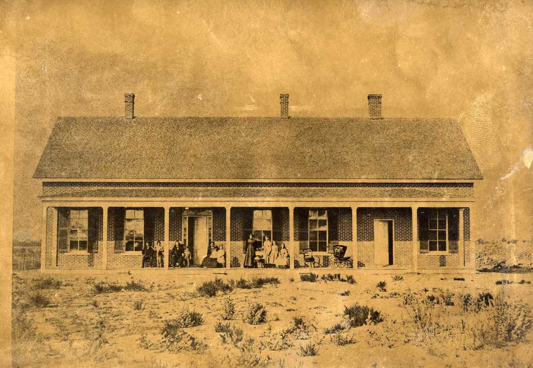
Jensen Alvarado Ranch
Monument and historic site · National Register of Historic Places · 4.0 mi
Human settlement in Jurupa Valley, California, United States of America
Masonic Temple
Monument and historic site · National Register of Historic Places · 3.0 mi
Masonic temple in Riverside, California

Mission Inn
Monument and historic site · National Register of Historic Places · 3.3 mi
Hotel in Riverside, California

Riverside Art Museum
Museum · National Register of Historic Places · 3.3 mi
Art museum in Riverside, California

Riverside Municipal Auditorium
Cinema and theater · National Register of Historic Places · 3.3 mi
Event venue in Riverside, California, U.S
Riverside station
Monument and historic site · National Register of Historic Places · 3.2 mi
Former railway station in Riverside, California


Victoria Avenue
Monument and historic site · National Register of Historic Places · 0.9 mi
Street in Riverside, California, United States of America
California Citrus State Historic Park
Museum · 3.3 mi
Historic site in California, United States
26 more on the map.
Parks, trails and playgrounds9

Martha McLean – Anza Narrows
Park · 2.6 mi
Regional park in California, United States
Fairmount Park
Park · 4.2 mi
Park in Riverside, California, United States of America

Restaurants and cafes252

The Old Spaghetti Factory
Restaurant · Italian · 3.3 mi
Italian restaurant with traditional entrees.
3191 Mission Inn Avenue, Riverside
Mo-Th, Su 11:30-21:30; Fr, Sa 11:30-22:00

7 Leaves Cafe
Cafe · Coffee Shop, Vietnamese · 4.1 mi
1201 University Avenue, Riverside
Mo-Th 07:00-22:00; Fr 07:00-23:00; Sa 08:00-23:00; Su 08:00-22:00

Beignet Spot
Cafe · Chicken · 3.1 mi
4019 Market Street
Mo-We 08:00-17:00; Th-Sa 08:00-19:00; Su 09:00-15:00
Butch's Grinders
Restaurant · Sandwich · 2.7 mi
4602 Pine Street, Riverside
Mo-Sa 09:00-20:00; Su 10:00-16:00
Daily Brew Coffee House
Cafe · Coffee Shop · 3.1 mi
2955 Van Buren Boulevard, Riverside
Mo-Su 05:30-17:00
Palenque Kitchen by Mezcal
Restaurant · Mexican · 3.2 mi
3737 STE 101 Main Street
Su-Mo 11:00-21:00; Tu 11:00-22:00; We-Th 17:00-22:00; Fr-Sa 11:00-01:00
R Burgers
Restaurant · Burger, Breakfast · 3.7 mi
1666 University Avenue, Riverside
Mo-Sa 06:00-23:00; Su 07:00-23:00
Sushi Asahi
Restaurant · Japanese, Sushi · 3.1 mi
2955 Van Buren Boulevard, Riverside
Mo-Th 11:30-21:30; Fr-Su 11:30-22:00
240 more on the map.
History
In the late 18th century and the early 19th century, the area was inhabited by Cahuilla and the Serrano people. Californios such as Bernardo Yorba and Juan Bandini established ranches during the first half of the 19th century.
In the 1860s, Louis Prevost launched the California Silk Center Association, a short-lived experiment in sericulture. In the wake of its failure, John W. North purchased some of its land and formed the Southern California Colony Association to promote the area's development. In March 1870, North distributed posters announcing the formation of a colony in California. North, a staunch temperance-minded abolitionist from the State of New York, had formerly founded Northfield, Minnesota. Riverside was temperance-minded, and Republican. There were four saloons in Riverside when it was founded. The license fees were raised until the saloons moved out of Riverside. Investors from England and Canada transplanted traditions and activities adopted by prosperous citizens. As a result, the first golf course and polo field in southern California were built in Riverside.
From the History section of Riverside, California on Wikipedia, under CC BY-SA 4.0.
Where to stay1
Churches and places of worship150
First Church of Christ, Scientist
Church · National Register of Historic Places · 3.3 mi
First Congregational Church of Riverside
Church · National Register of Historic Places · 3.2 mi
Universalist Unitarian Church of Riverside
Church · National Register of Historic Places · 3.3 mi
Shopping29
Gas and EV charging54
Riverside - Canyon Springs Parkway Supercharger
EV charging · 6.3 mi
2755 Canyon Springs Parkway, Riverside
Schools, colleges and libraries82
California School For The Deaf-Riverside
School · 0.8 mi
3044 Horace St., Riverside
Healthcare19
Riverside University Health System - Arlington Mental Health Facility
Hospital · 4.0 mi
9990 County Farm Road, Riverside
Riverside University Health System - Arlington Recovery Community
Hospital · 4.1 mi
10001 County Farm Road, Riverside
Map of Riverside
250 places. The map loads OpenStreetMap tiles when you open it.
Climate by month
Monthly table
| Month | High | Low | Rain | Snow |
|---|---|---|---|---|
| Jan | 70°F | 43°F | 2.2 in | 0.0 in |
| Feb | 70°F | 44°F | 2.5 in | 0.0 in |
| Mar | 73°F | 46°F | 1.6 in | 0.0 in |
| Apr | 78°F | 50°F | 0.6 in | 0.0 in |
| May | 81°F | 55°F | 0.2 in | 0.0 in |
| Jun | 89°F | 59°F | 0.1 in | 0.0 in |
| Jul | 95°F | 64°F | 0.1 in | 0.0 in |
| Aug | 97°F | 64°F | 0.1 in | 0.0 in |
| Sep | 93°F | 62°F | 0.1 in | 0.0 in |
| Oct | 84°F | 54°F | 0.4 in | 0.0 in |
| Nov | 76°F | 46°F | 0.7 in | 0.0 in |
| Dec | 69°F | 42°F | 1.4 in | 0.0 in |
U.S. Climate Normals 1991-2020 for Riverside Fire Stn 3 (1 mi away), NOAA NCEI.
People and cost of living
American Community Survey 5-year estimates, 2020-2024, U.S. Census Bureau. Estimates have margins of error, larger for small towns.
Disaster history
Riverside County has had 47 federal disaster declarations since 2000, most often for fires.
- 2026-05-20: Bain Fire (Fire)
- 2024-09-11: Airport Fire (Fire)
- 2024-07-21: Hawarden Fire (Fire)
- 2023-11-21: Tropical Storm Hilary (Hurricane)
- 2023-01-09: Severe Winter Storms, Flooding, And Mudslides (Flood)
- 2022-09-06: Fairview Fire (Fire)
OpenFEMA disaster declarations summaries.
Getting there and nearby towns
- Woodcrest 4 mi south, about 7 min by car
- Jurupa Valley 6 mi northwest, about 10 min by car
- El Sobrante 6 mi southwest, about 10 min by car
- Grand Terrace 8 mi northeast, about 13 min by car
- Home Gardens 8 mi southwest, about 13 min by car
- Bloomington 8 mi north, about 14 min by car
- Colton 9 mi northeast, about 14 min by car
- Norco 9 mi west, about 15 min by car
- Mead Valley 10 mi southeast, about 15 min by car
- Moreno Valley 11 mi east, about 17 min by car
Drive times are estimates from straight-line distance, not routes.
Local news
Headlines from INDB, the NEMICO news database.
Reviews, tips and questions
Loading what members have shared...
Sources and licences
- NCES EDGE (Public domain): public schools
- NOAA NCEI U.S. Climate Normals 1991-2020 (Public domain): climate by month
- OpenFEMA (Public domain): disaster declarations
- OpenStreetMap contributors (ODbL 1.0): places, airports, map data
- U.S. Census Bureau (Public domain): population, income, housing, education, commute
- Wikidata (CC0 1.0): elevation, founding date, time zone, website, landmarks and historic places
- Wikimedia Commons (see each image): photos
- Wikipedia (CC BY-SA 4.0): overview and history text
Photo credits
- Race and ethnicity 2010- Riverside (5560442038), Eric Fischer, CC BY-SA 2.0
- Parent Navel Orange Tree Riverside, Eric T. Gunther, CC BY 3.0
- Riverside Gold Star Mothers Plaque, Josiah.r.white, CC0
- First Church Of Christ Historical 0196 Wiki a, Steve Rouhotas, CC BY-SA 3.0
- Harada House 20091024c, MissionInn.Jim, Public domain
- Exterior view of the Frank Miller's Glenwood Mission Inn (hotel), Riverside, ca.1910 (CHS-5259), C. C. Pierce, Public domain
- FirstCongregationalChurch20090821f, MissionInn.Jim, Public domain
- RiversideArtMuseum20090821g, Unknown author, Public domain
- JensenAlvaradoRanch1870, Jensen Alvarado (Life time: 1870), Public domain
- All Souls Universalist Church, Steve Rouhotas, CC BY-SA 3.0
- RiversideCA VictoriaAve, Qwerty510 at English Wikipedia, Public domain
- RiversideMunicipalAuditorium20090821z, MissionInn.Jim, Public domain
- Heritage House - Riverside, California, Mliedel, CC BY-SA 3.0
- Riverside Library, Mliedel, CC BY-SA 3.0
- Fiat 500 Spiaggina 58, nccmrm97, CC BY-SA 2.0
- Magnolia United Presbyterian Church, Mimir557, CC BY-SA 4.0
- Washington Navel Orange Tree Exterior, Josiah.r.white, CC0
- Parent Washington Navel Orange Tree, Riley Mayuga, CC BY-SA 3.0
- Marsh Grapefruit Tree Commemorative Plaque, Josiah.r.white, CC0
- Chicago White Sox Redwood Tree Plaque, Josiah.r.white, CC0
- Chicago White Sox Redwood Tree and Low Park, Josiah.r.white, CC0
- Jessie C. Underwood Plaque, Josiah.r.white, CC0
- Holden House Exterior, Josiah.r.white, CC0
- Hartree Grove Exterior, Josiah.r.white, CC0
- Hartree Grove City Landmark Plaque, Josiah.r.white, CC0
- Victoria Avenue 1928 concrete bridge from street view, 3Kathleen3, CC BY-SA 3.0
- Arch given by Friends of Victoria Avenue, 3Kathleen3, CC BY-SA 3.0
- Victoria Avenue south to Central Avenue, 3Kathleen3, CC BY-SA 3.0
- Victoria Avenue 1928 concrete bridge, 3Kathleen3, CC BY-SA 3.0
- Palm Elementary School City Landmark Plaque, Josiah.r.white, CC0
- John Swanson House Exterior, Dan Cocco, CC0
- John Swanson Residence City Landmark Plaque, Josiah.r.white, CC0


Page built October 30, 2026. Spotted a mistake? Tell us or suggest a place.