


Romulus, Michigan
Romulus is a city of 24,831 people in Wayne County, Michigan, founded in 1826.
Why visit Romulus
Townapedia lists 14 museums and landmarks, 50 parks and trails, 152 places to eat, 30 places to stay and 5 attractions in and around town.
Highlights include State-Wayne Theater, Waltz Road–Huron River Bridge, Annapolis Park Historic District and Ephraim and Emma Woodworth Truesdell House.
July is the warmest month, with average highs of 84°F; January lows average 19°F, and about 45 inches of snow fall in a normal year.
Weather in Romulus
Forecast from the National Weather Service. Full forecast
About Romulus
Romulus is a city in Wayne County in the U.S. state of Michigan. A western suburb of Detroit, Romulus is located roughly 20 miles (32.2 km) southwest of downtown Detroit, and is most notable as the location of Detroit Metropolitan Airport. As of the 2020 census, the city had a population of 25,178.
From the Wikipedia article Romulus, Michigan (this version), under CC BY-SA 4.0.
Things to do5

State-Wayne Theater
Cinema and theater · 4.4 mi
Movie theater and theater in Wayne, Michigan, United States
35310 West Michigan Avenue, Wayne

Waltz Road–Huron River Bridge
Bridge · National Register of Historic Places · 4.5 mi
NRHP-listed bridge in Michigan
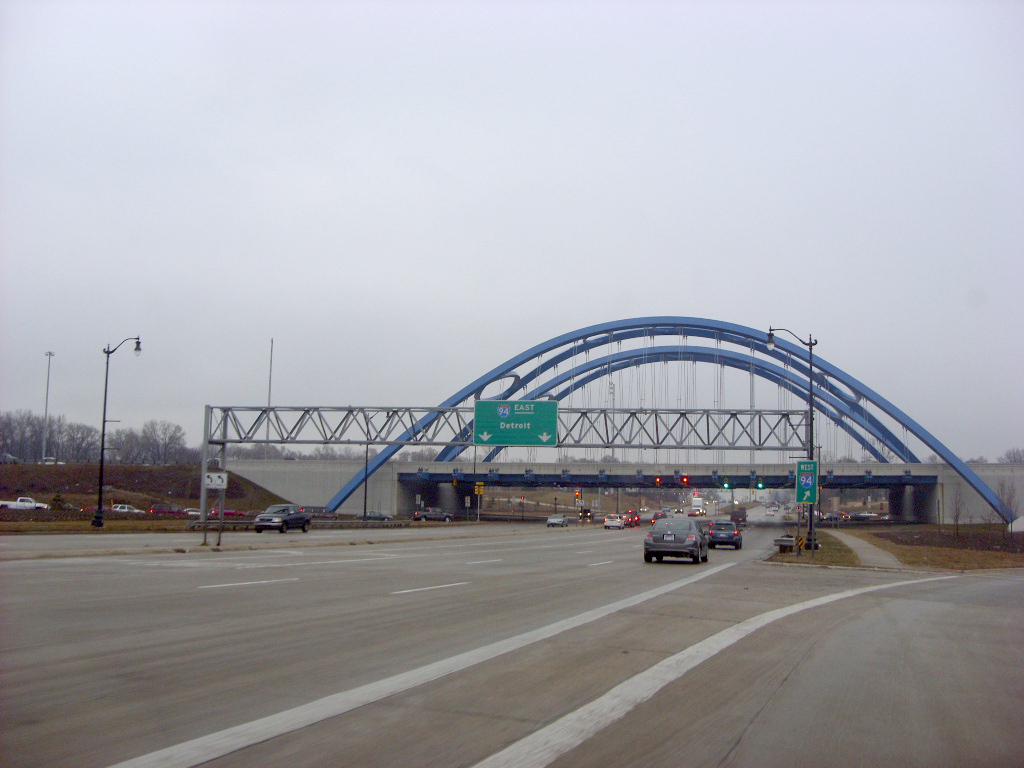
Gateway Bridge (Michigan)
Bridge · 5.8 mi
Tied-arch bridge in Taylor, Michigan


Museums and landmarks14

Annapolis Park Historic District
Monument and historic site · National Register of Historic Places · 3.8 mi
Historic district in Westland, Michigan

Ephraim and Emma Woodworth Truesdell House
Monument and historic site · National Register of Historic Places · 6.8 mi
Historic house in Michigan, United States

John and Edna Truesdell Fischer Farmstead
Monument and historic site · National Register of Historic Places · 6.5 mi
House in Sheldon, Michigan, NRHP-listed

Lilley Road–Lower Rouge River Bridge
Bridge · National Register of Historic Places · 6.1 mi
Place in Michigan listed on National Register of Historic Places

Malcolm X House
Monument and historic site · National Register of Historic Places · 4.8 mi
House in Inkster, Michigan, United States of America

Norwayne Historic District
Monument and historic site · National Register of Historic Places · 4.9 mi
Historic district in Westland, Michigan, United States

Sheldon Inn
Monument and historic site · National Register of Historic Places · 6.6 mi
Building in Michigan, United States

Romulus Historical Museum
Museum · 1.4 mi
11120 Hunt Street, Romulus
Northwest Airlines Flight 255 Crash Site Memorial
Monument and historic site · 2.5 mi
2 more on the map.
Parks, trails and playgrounds50


Lower Huron Metropark
Park · 4.4 mi
Public park in Wayne County, Michigan




38 more on the map.
Restaurants and cafes152


Mr. Pizza
Restaurant · Pizza · 4.1 mi
9860 Haggerty Road, Belleville
Mo-Th 10:00-22:00; Fr 10:00-24:00; Sa 11:00-24:00; Su 12:00-22:00

Tim Hortons
Cafe · Coffee Shop · 3.0 mi
7070 Middlebelt Road, Romulus
Mo-We 06:00-20:00; Fr 06:00-20:00; Sa-Su 06:00-18:00
Tim Hortons
Cafe · Coffee Shop · 3.5 mi
39315 Ecorse Road, Romulus
Mo-We 06:00-18:00; Fr-Su 06:00-18:00
Tim Hortons
Cafe · Coffee Shop · 3.7 mi
11175 Haggerty Road, Belleville
Mo 05:00-22:00; Tu-We 04:00-23:00; Fr-Sa 04:00-23:00; Su 04:30-22:00
Biggby Coffee
Cafe · Coffee Shop · 4.1 mi
25700 Goddard Road
Mo-Fr 06:00-20:00; Sa 06:00-20:00; Su 07:00-20:00
140 more on the map.
History
The first white settler in Romulus was Samuel Polyne, a French Canadian, who settled on section 2 in 1826, though he left soon after the township was organized in 1835.
The first settler in the village proper (prior to the 1865 annexation of the whole village and township into one city) was Samuel McMath, who moved from New York state to the area in 1827. He improved land and planned to bring his family to settle there, but he died before he could carry out this plan.
Solomon Whitaker, Charles and Joseph Pulcifer located in the area in 1830, and in 1833, Jenks Pullen and his six sons settled at what became known as "Pullen's Corners" (located in section 19 at the intersection of Ozga and Goddard roads, now commonly called "Five Points"). Pullen's Corners was platted in 1836. The community later took on the name of the township.
The township of Romulus was set off from a part of Huron Township by an act of the Michigan Territorial Council on March 17, 1835, and the first township meeting was held on April 16, 1835, two years before the State of Michigan was admitted in to the Union (1837), in the house of Joseph T. Pullen. The first supervisor was David J. Pullen. The township's name was changed to "Wayne" on March 19, 1845, but was changed back to Romulus on January 16, 1848.
From the History section of Romulus, Michigan on Wikipedia, under CC BY-SA 4.0.
Where to stay30
Fairfield Inn & Suites Detroit Metro Airport Romulus
Motel and hotel · 2.0 mi
7800 Merriman Road, Romulus
SpringHill Suites by Marriott Detroit Metro Airport Romulus
Motel and hotel · 1.8 mi
8280 Merriman Road, Romulus
Churches and places of worship24
St Joseph Traditional Catholic Church
Church · Catholic · 4.2 mi
3521 4th Street, Wayne
Shopping15
Gas and EV charging54
Schools, colleges and libraries78
Wayne County Community College District - Ted Scott Campus
School · 3.9 mi
9555 Haggerty Road, Belleville
Healthcare11
Primary Care & Urgent Care
Clinic and pharmacy · 5.0 mi
24345 Northline Road, Taylor
Map of Romulus
250 places. The map loads OpenStreetMap tiles when you open it.
Climate by month
Monthly table
| Month | High | Low | Rain | Snow |
|---|---|---|---|---|
| Jan | 32°F | 19°F | 2.2 in | 14.0 in |
| Feb | 35°F | 21°F | 2.1 in | 12.5 in |
| Mar | 46°F | 29°F | 2.4 in | 6.2 in |
| Apr | 59°F | 39°F | 3.3 in | 1.5 in |
| May | 70°F | 50°F | 3.7 in | 0.0 in |
| Jun | 80°F | 60°F | 3.3 in | 0.0 in |
| Jul | 84°F | 64°F | 3.5 in | 0.0 in |
| Aug | 81°F | 63°F | 3.3 in | 0.0 in |
| Sep | 74°F | 56°F | 3.2 in | 0.0 in |
| Oct | 62°F | 44°F | 2.5 in | 0.0 in |
| Nov | 49°F | 34°F | 2.6 in | 1.9 in |
| Dec | 37°F | 25°F | 2.2 in | 8.9 in |
U.S. Climate Normals 1991-2020 for Detroit Metro Ap 72537 (2 mi away), NOAA NCEI.
People and cost of living
American Community Survey 5-year estimates, 2020-2024, U.S. Census Bureau. Estimates have margins of error, larger for small towns.
Disaster history
Wayne County has had 9 federal disaster declarations since 2000, most often for severe storms.
- 2024-02-08: Severe Storms, Tornadoes, And Flooding (Flood)
- 2021-07-15: Severe Storms, Flooding, And Tornadoes (Severe Storm)
- 2020-03-27: Covid-19 Pandemic (Biological)
- 2020-03-13: Covid-19 (Biological)
- 2014-09-25: Severe Storms And Flooding (Flood)
- 2005-09-07: Hurricane Katrina Evacuation (Hurricane)
OpenFEMA disaster declarations summaries.
Getting there and nearby towns
Detroit Metropolitan Airport (DTW) is the nearest airport with scheduled flights listed in OpenStreetMap, 1 miles away.
- Inkster 6 mi northeast, about 9 min by car
- Garden City 7 mi north, about 12 min by car
- Allen Park 8 mi east, about 14 min by car
- Dearborn Heights 9 mi northeast, about 14 min by car
- Riverview 9 mi east, about 15 min by car
- Dearborn 10 mi northeast, about 16 min by car
- Lincoln Park 10 mi east, about 16 min by car
- Flat Rock 10 mi southeast, about 16 min by car
- Melvindale 10 mi northeast, about 17 min by car
- Livonia 12 mi north, about 20 min by car
Drive times are estimates from straight-line distance, not routes.
Local news
Headlines from INDB, the NEMICO news database.
Reviews, tips and questions
Loading what members have shared...
Sources and licences
- NCES EDGE (Public domain): public schools
- NOAA NCEI U.S. Climate Normals 1991-2020 (Public domain): climate by month
- OpenFEMA (Public domain): disaster declarations
- OpenStreetMap contributors (ODbL 1.0): places, airports, map data
- U.S. Census Bureau (Public domain): population, income, housing, education, commute
- Wikidata (CC0 1.0): elevation, founding date, time zone, website, landmarks and historic places
- Wikimedia Commons (see each image): photos
- Wikipedia (CC BY-SA 4.0): overview and history text
Photo credits
- Romulus-MI-01s, Traveler100, CC BY-SA 3.0
- Romulus, MI, USA - panoramio (3), Eric Friedebach, CC BY 3.0
- State Wayne Theater, Wayne Michigan, Dwight Burdette, CC BY 3.0
- NorwayneStreetscapeSingleFam, Andrew Jameson, CC BY-SA 3.0
- EphraimAndEmmaWoodworthTruesdellHouseCantonMi, Andrew Jameson, CC BY-SA 3.0
- Waltz Road-Huron River Bridge New Boston MI, Andrew Jameson, CC BY-SA 3.0
- LilleyRoadLowerRougeRiverBridgeCantonMi, Andrew Jameson, CC BY-SA 3.0
- JohnAndEdnaTrusdellFischerHouseCantonMi, Andrew Jameson, CC BY-SA 3.0
- SheldonInnCantonMi, Andrew Jameson, CC BY-SA 3.0
- Annapolis Park A, Andrew Jameson, CC BY-SA 3.0
- I-94 bridge over US 24, Doug Kerr from Albany, NY, United States, CC BY-SA 2.0
- Willow metropark children's play area, Dwight Burdette, CC BY 3.0
- Lower huron metropark huron river bridge, Dwight Burdette, CC BY 3.0
- N606NK (7785048896), redlegsfan21 from Vandalia, OH, United States, CC BY-SA 2.0
- FedEx B757-230(F), N997FD, as FX 1982 EWR-DTW (16786958988), Charles from Port Chester, New York, CC BY 2.0
- FedEx B757-23A(SF), N994FD, as FX 1982 EWR-DTW (16353218824), Charles from Port Chester, New York, CC BY 2.0
- FedEx DC-10-30(F), N559FE, as FX 1711 IND-DTW (16786962978), Charles from Port Chester, New York, CC BY 2.0
- FedEx DC-10-10(F), N570FE, as FX 1711 IND-DTW (16974340992), Charles from Port Chester, New York, CC BY 2.0
- N7547A (6302436763), redlegsfan21 from Vandalia, OH, United States, CC BY-SA 2.0
- N424UA (7896610660), redlegsfan21 from Vandalia, OH, United States, CC BY-SA 2.0
- N909XJ (6302434695), redlegsfan21 from Vandalia, OH, United States, CC BY-SA 2.0
- Delta Air Lines B767-332(ER), N173DZ, as DL 52 GRU-DTW (16974649561), Charles from Port Chester, New York, CC BY 2.0
- DTW Tram 2, Sanibel sun at English Wikipedia, Public domain
- Delta Air Lines A320-211, N328NW, as DL 1619 ATL-DTW (16354530203), Charles from Port Chester, New York, CC BY 2.0
- Delta Air Lines B737-932(ER), N808DN, as DL 1604 FLL-DTW (16973695721), Charles from Port Chester, New York, CC BY 2.0
- Delta Air Lines B737-932(ER), N825DN, as DL 86 SAN-DTW (16973730511), Charles from Port Chester, New York, CC BY 2.0
- N663US (6302961824), redlegsfan21 from Vandalia, OH, United States, CC BY-SA 2.0
- Expressjet CRJ-200(ER), N838AS, as DL 4882 BTV-DTW (16767271057), Charles from Port Chester, New York, CC BY 2.0
- SkyWest Airlines CRJ-200(ER), N440SW, as DL 4440 GRB-DTW (16958126746), Charles from Port Chester, New York, CC BY 2.0
- N453XJ (6302964076), redlegsfan21 from Vandalia, OH, United States, CC BY-SA 2.0
- Detroit Metropolitan Wayne County Airport, Detroit, United States (Unsplash), Augusto Navarro augustnn, CC0
- N8883E (7896610060), redlegsfan21 from Vandalia, OH, United States, CC BY-SA 2.0
- Spirit Airlines A319-132, N534NK, as NK 645 DTW-TPA (16355576963), Charles from Port Chester, New York, CC BY 2.0
- N344NB Delta Air Lines Airbus A319-114 DTW 300119, Steve Knight, CC BY 2.0
- Detroit Metropolitan Wayne County International Airport, Detroit, Michigan, USA - panoramio (1), qwesy qwesy, CC BY 3.0
- Aircraft Cabin 1 2016-08-22, F ASTILY, CC BY-SA 4.0
- Delta Air Lines B757-351, N589NW, as DL 212 DTW-RSW (16787153640), Charles from Port Chester, New York, CC BY 2.0
- Mesa Airlines E-175(LR), N85320, as UA 3746 DTW-IAH (16776808087), Charles from Port Chester, New York, CC BY 2.0
- N672DL (7640945524), redlegsfan21 from Vandalia, OH, United States, CC BY-SA 2.0
- Delta Air Lines B757-232, N699DL, as DL 748 DTW-ATL (16786915648), Charles from Port Chester, New York, CC BY 2.0


Page built October 30, 2026. Spotted a mistake? Tell us or suggest a place.