
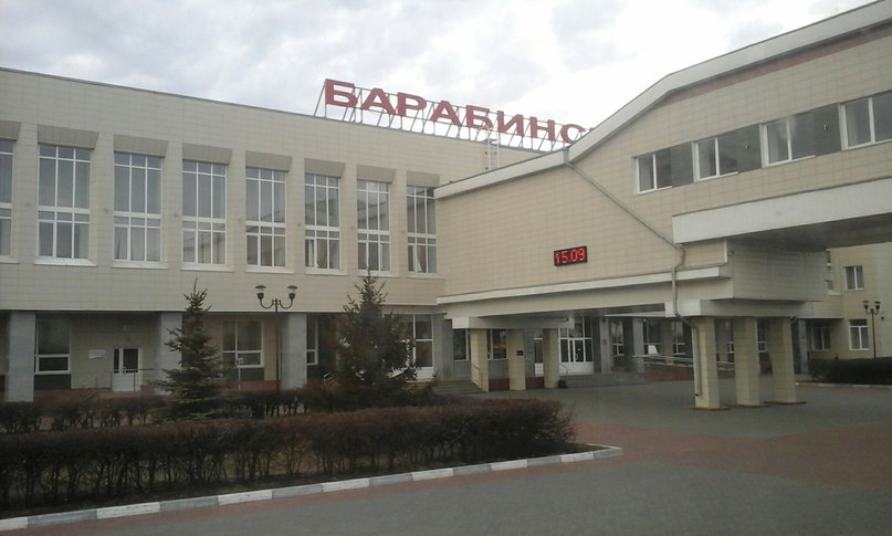


Barabinsk, Russia
Барабинск
Barabinsk is a town of 31,508 people in Novosibirsk Oblast, Russia, founded in 1893.
Why visit Barabinsk
Townapedia lists 11 museums and landmarks, 1 park or trail, 6 places to eat and 2 places to stay in and around town.
Weather in Barabinsk
Forecast from MET Norway (CC BY 4.0). Full forecast
About Barabinsk
Barabinsk (Russian: Бара́бинск, Siberian Tatar: Көгүтей-тура, romanized: Köğütey-Tura) is a town in Novosibirsk Oblast, Russia, located in the Baraba Steppe on the Trans-Siberian Railway between Omsk and Novosibirsk. Population: 30,394 (2010 census); 32,501 (2002 census); 36,501 (1989 Soviet census).
From the Wikipedia article Barabinsk (this version), under CC BY-SA 4.0.
Museums and landmarks11

Parks, trails and playgrounds1

Restaurants and cafes6


Where to stay2


History
The town of Barabinsk is named after Baraba Tatars, the indigenous inhabitants of the Baraba steppe. During the construction of the Trans-Siberian Railway, the swampy terrain forced the railway line to be laid away from the town of Kainsk. The Kainsk-Tomsky railway station (opened in 1896) was built at the point closest to the town, and a settlement for railway employees sprang up around it.
The settlement developed rapidly, and in 1911 a project was proposed to create a town called Alexeyevsk based on the station settlement, whose population had already reached 4,000 by that time. At a meeting of the provincial board for peasant affairs held on 18 March 1911, it was resolved that "the settlement at Kainsk station is to be recognised as subject to conversion into a non-district town with simplified administration"; however, for reasons that are not entirely clear, the change in status did not occur. It was only towards the end of 1916 that the settlement at Kainsk station became a non-district town of Tomsk Governorate, named Barabinsk after its location on the Baraba Lowland.
In 1920, the first issue of the newspaper Barabinsky Vestnik was published, then called Izvestiya of the Barabinsk Revolutionary Committee.
From the History section of Barabinsk on Wikipedia, under CC BY-SA 4.0.
Churches and places of worship1
Shopping8
Gas and EV charging4
Schools, colleges and libraries1
Healthcare2
Map of Barabinsk
36 places. The map loads OpenStreetMap tiles when you open it.
Getting there and nearby towns
- Kuybyshev 11 km north, about 11 min by car
- Zdvinsk 75 km south, about 1 h 15 min by car
- Tagan 81 km southwest, about 1 h 15 min by car
Drive times are estimates from straight-line distance, not routes.
Local news
Headlines from INDB.
Reviews, tips and questions
Loading what members have shared...
Sources and licences
- GeoNames (CC BY 4.0): population, coordinates, regions and time zone
- OpenStreetMap contributors (ODbL 1.0): places, airports, map data
- Wikidata (CC0 1.0): elevation, founding date, time zone, website
- Wikimedia Commons (see each image): photos
- Wikipedia (CC BY-SA 4.0): overview and history text
Photo credits
- Вокзал станции Барабинск, Илья Драконов, CC BY-SA 4.0
- Barabinsk railway station platforms, Ninara from Helsinki, Finland, CC BY 2.0
- 4Y1A8602 Barabinsk, Russia (28254995626), Ninara from Helsinki, Finland, CC BY 2.0
- Barabinsk, Russia (11442718515), Clay Gilliland, CC BY-SA 2.0
- Arriving Barabinsk, Russia (11442928204), Clay Gilliland, CC BY-SA 2.0
- Near Barabinsk, Russia (11442878865), Clay Gilliland, CC BY-SA 2.0
- R254 cloverleaf interchange near Barabinsk, Rosavtodor, CC BY 4.0
- Л-1067 Барабинск тыл, Апатинаити, CC BY-SA 3.0
- Паровоз и электровоз на станции Барабинск, MikSed, CC BY-SA 4.0
- Электровоз ЭП2К-345 на станции Барабинск, MikSed, CC BY-SA 4.0
- Л-1067 Барабинск шильд, Апатинаити, CC BY-SA 3.0
- Паровоз Л-1067 на станции Барабинск, MikSed, CC BY-SA 4.0
- Л-1067 Барабинск памятник, Апатинаити, CC BY-SA 3.0
- Электровоз ЧС2-010 на станции Барабинск, MikSed, CC BY-SA 4.0
- Станция Барабинск (вокзал), MikSed, CC BY-SA 4.0
- Сибиряк-Барабинец мемдоска, Апатинаити, Public domain
- ЧС2-010 Барабинск пам, Апатинаити, CC BY-SA 3.0


Page built November 4, 2026. Spotted a mistake? Tell us or suggest a place.