
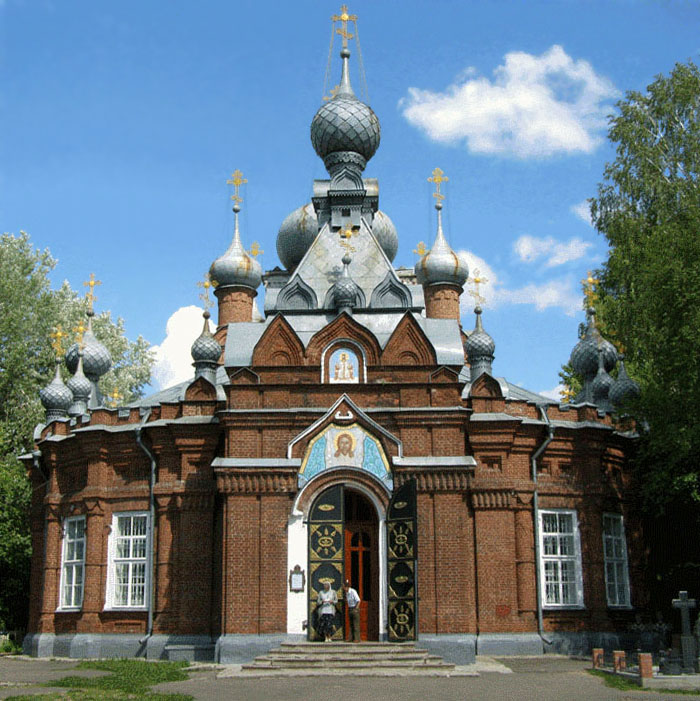


Why visit Bezhetsk
Townapedia lists 20 museums and landmarks, 6 parks and trails, 14 places to eat, 2 places to stay and 1 attraction in and around town.
Highlights include Дом детства и юношества and Районный Дом народного творчества.
Weather in Bezhetsk
Forecast from MET Norway (CC BY 4.0). Full forecast
About Bezhetsk
Bezhetsk (Russian: Бе́жецк) is a town and the administrative center of Bezhetsky District in Tver Oblast, Russia, located on the Mologa River at its confluence with the Ostrechina. Population: 24,522 (2010 census); 28,643 (2002 census); 30,377 (1989 Soviet census); 20,618 (2024). It was previously known as Gorodetsk (until 1766).
From the Wikipedia article Bezhetsk (this version), under CC BY-SA 4.0.
Things to do1

Museums and landmarks20


8 more on the map.
Parks, trails and playgrounds6

Restaurants and cafes14



2 more on the map.
History
The settlement of Bezhichi was first mentioned in 1137, when it was owned by Novgorod. The original name, with the literal meaning of "refugees", suggests that early settlers were former Novgorodians. Historical Bezhichi was located 20 kilometers (12 mi) north from the present-day town; the settlement was destroyed by raiders in 1272 and re-established on the present site as the fortress of Gorodetsk (Городецк).
In the early 15th century, the area of Bezhetsky Verkh was annexed by Grand Duchy of Moscow. Since 1433, Bezhetsk had its own prince, who was subordinate to the Grand Prince of Moscow.
In the course of the administrative reform carried out in 1708 by Peter the Great, Gorodetsk was included into Ingermanland Governorate (known since 1710 as St. Petersburg Governorate), but in 1727 it was transferred to Moscow Governorate. In 1766, Gorodetsk was renamed Bezhetsk. In 1775, Tver Viceroyalty was formed from the lands which previously belonged to Moscow and Novgorod Governorates. In 1776, Bezhetsk became the seat of Bezhetsky Uyezd. In 1796, Tver Viceroyalty was transformed into Tver Governorate. Bezhetsk remained the administrative center of the uyezd until 1929.
From the History section of Bezhetsk on Wikipedia, under CC BY-SA 4.0.
Where to stay2
Churches and places of worship14
Церковь Преображения Господня
Church · Russian Orthodox · 0.7 km
31 площадь им. Константина Чернышова
Церковь Покрова Пресвятой Богородицы при Тюремном замке (старая)
Church · 2.0 km
28 Тверская улица
Shopping19
Gas and EV charging4
Schools, colleges and libraries12
Healthcare8
Map of Bezhetsk
100 places. The map loads OpenStreetMap tiles when you open it.
Getting there and nearby towns
- Sonkovo 27 km east, about 27 min by car
- Krasnyy Kholm 40 km northeast, about 40 min by car
- Kesova Gora 42 km southeast, about 42 min by car
- Molokovo 43 km north, about 43 min by car
- Maksatikha 49 km west, about 49 min by car
- Rameshki 63 km southwest, about 1 h by car
- Kashin 72 km southeast, about 1 h 15 min by car
- Sandovo 77 km north, about 1 h 15 min by car
- Breytovo 89 km northeast, about 1 h 30 min by car
- Lesnoye 89 km northwest, about 1 h 30 min by car
Drive times are estimates from straight-line distance, not routes.
Local news
Headlines from INDB.
Reviews, tips and questions
Loading what members have shared...
Sources and licences
- GeoNames (CC BY 4.0): population, coordinates, regions and time zone
- OpenStreetMap contributors (ODbL 1.0): places, airports, map data
- Wikidata (CC0 1.0): elevation, founding date, time zone, website
- Wikimedia Commons (see each image): photos
- Wikipedia (CC BY-SA 4.0): overview and history text
Photo credits
- Спасо-кладбищенский храм (Бежецк), Александр Симонов ( user:alsim ), Public domain
- Bezhetsk, Tverskaya oblast', Russia - panoramio (1), Лач Андрей, CC BY-SA 3.0
- Bezetsk 2020-12 1 7, Svetlov Artem, CC0
- Bezetsk 2020-12 1 5, Svetlov Artem, CC0
- Bezetsk 2020-12 1 6, Svetlov Artem, CC0
- Bezetsk 2020-12 1 8, Svetlov Artem, CC0
- Bezetsk 2020-12 2 11, Svetlov Artem, CC0
- Bezetsk 2020-12 2 12, Svetlov Artem, CC0
- Bezetsk 2020-12 2 13, Svetlov Artem, CC0
- Bezetsk 2020-12 2 6, Svetlov Artem, CC0
- Bezetsk 2020-12 4 5, Svetlov Artem, CC0
- Bezetsk 2020-12 5, Svetlov Artem, CC0
- Bezetsk 2020-12 5 3, Svetlov Artem, CC0
- Bezetsk 2020-12 1 11, Svetlov Artem, CC0
- Bezetsk 2020-12 2 4, Svetlov Artem, CC0
- Bezetsk 2020-12 5 5, Svetlov Artem, CC0
- Bezetsk 2020-12 5 8, Svetlov Artem, CC0
- Bezetsk 2020-12 5 6, Svetlov Artem, CC0
- Bezetsk 2020-12 5 4, Svetlov Artem, CC0
- Памятник в Бежецке 2, Milomory, CC BY-SA 4.0
- Bezetsk 2020-12 5 2, Svetlov Artem, CC0
- Bezetsk 2020-12 5 9, Svetlov Artem, CC0
- Bezetsk 2020-12 4 6, Svetlov Artem, CC0
- Купеческий дом, Большая улица, 59-27, Александра продукт распада П, CC BY-SA 4.0
- Бежецк. Деревянные дома. 2, Svetlov Artem, CC0
- Бежецк. Деревянные дома. 4, Svetlov Artem, CC0
- Bezetsk 2020-12 4 7, Svetlov Artem, CC0
- Bezetsk 2020-12 4 14, Svetlov Artem, CC0
- Памятник в Бежецке 1, Milomory, CC BY-SA 4.0
- Кафедральный собор Спаса Нерукотворного образа (Бежецк), Андрей Агафонов, CC BY-SA 4.0
- Bezetsk 2020-12 4 16, Svetlov Artem, CC0
- Bezetsk 2020-12 5 7, Svetlov Artem, CC0
- Bezetsk 2020-12 1 9, Svetlov Artem, CC0
- Bezetsk 2020-12 2 15, Svetlov Artem, CC0
- Bezetsk 2020-12 1 4, Svetlov Artem, CC0
- Bezetsk 2020-12 4 8, Svetlov Artem, CC0
- Bezetsk 2020-12 4 13, Svetlov Artem, CC0
- Bezetsk 2020-12 2 2, Svetlov Artem, CC0
- Bezetsk 2020-12 4 10, Svetlov Artem, CC0
- ОСОБНЯК БРАТЬЕВ НЕВОРТИНЫХ, НАЧ. XX В, ElenaVoskresenskaya, CC BY-SA 4.0


Page built November 4, 2026. Spotted a mistake? Tell us or suggest a place.