
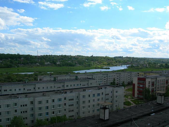


Dorogobuzh, Russia
Дорогобуж
Dorogobuzh is a town of 12,293 people in Smolensk Oblast, Russia.
Why visit Dorogobuzh
Townapedia lists 3 museums and landmarks and 2 places to stay in and around town.
Weather in Dorogobuzh
Forecast from MET Norway (CC BY 4.0). Full forecast
About Dorogobuzh
Dorogobuzh (Russian: Дорогобуж; Belarusian: Дарагабуж) is a historic town and the administrative center of Dorogobuzhsky District in Smolensk Oblast, Russia, straddling the Dnieper River and located 125 kilometers (78 mi) east of Smolensk, the administrative center of the oblast. Population: 10,720 (2010 census); 12,250 (2002 census); 12,254 (1989 Soviet census).
From the Wikipedia article Dorogobuzh (this version), under CC BY-SA 4.0.
Museums and landmarks3

Where to stay2

Churches and places of worship3

Shopping5

History
First mentioned in 1150, it was established as a fortress defending eastern approaches to Smolensk. It was located in the Principality of Smolensk, which in 1404 became part of Lithuania. It passed to the Grand Duchy of Moscow after the Battle of Vedrosha in 1500. In 1508, Vasily III sent Italian masters to build a wooden fort there.
During the Time of Troubles, Dorogobuzh passed between Lithuania and various Muscovite factions several times, and was ravaged, with its population reduced to ten people in 1614. It was captured by Russia in 1613, and then re-captured by Polish Prince Władysław IV Vasa in 1617. Within the Polish–Lithuanian Commonwealth, it was part of the Smolensk Voivodeship. During the Smolensk War, in 1632, it was besieged and captured by Russia, however, it was restored to the Polish–Lithuanian Commonwealth by the Treaty of Polyanovka in 1634. In 1667, it passed to Russia.
During the Napoleonic Wars, it was captured by French troops in August 1812, and re-captured by Russia in October 1812. In the late 19th century, the town held an annual fair for grain, horses and cattle.
From the History section of Dorogobuzh on Wikipedia, under CC BY-SA 4.0.
Schools, colleges and libraries2
Healthcare2
Map of Dorogobuzh
17 places. The map loads OpenStreetMap tiles when you open it.
Getting there and nearby towns
Smolensk South Tikhvinka Airport (LNX) is the nearest airport with scheduled flights listed in OpenStreetMap, 81 km away.
- Verkhnedneprovskiy 8 km north, about 8 min by car
- Safonovo 22 km north, about 22 min by car
- Yel’nya 38 km south, about 38 min by car
- Glinka 41 km southwest, about 41 min by car
- Yartsevo 42 km northwest, about 42 min by car
- Kardymovo 55 km west, about 55 min by car
- Dukhovshchina 64 km northwest, about 1 h by car
- Ugra 68 km east, about 1 h 15 min by car
- Vyaz’ma 72 km northeast, about 1 h 15 min by car
- Smolensk 81 km west, about 1 h 15 min by car
Drive times are estimates from straight-line distance, not routes.
Local news
Headlines from INDB.
Reviews, tips and questions
Loading what members have shared...
Sources and licences
- GeoNames (CC BY 4.0): population, coordinates, regions and time zone
- OpenStreetMap contributors (ODbL 1.0): places, airports, map data
- Wikidata (CC0 1.0): elevation, founding date, time zone, website
- Wikimedia Commons (see each image): photos
- Wikipedia (CC BY-SA 4.0): overview and history text
Photo credits
- Dorogobuzh View of Dnieper, MaxS, CC BY-SA 3.0
- Dorogobuj-DSC 0147, Burov.yl, CC BY-SA 4.0
- Dorogobuj-DSC 0141, Burov.yl, CC BY-SA 4.0
- Dorogobuj-DSC 0193, Burov.yl, CC BY-SA 4.0
- Dorogobuj-DSC 0172, Burov.yl, CC BY-SA 4.0
- Dorogobuj-DSC 0190, Burov.yl, CC BY-SA 4.0
- Dorogobuj-DSC 0188, Burov.yl, CC BY-SA 4.0
- Dorogobuj-DSC 0184, Burov.yl, CC BY-SA 4.0
- Dorogobuj-DSC 0178, Burov.yl, CC BY-SA 4.0
- Dorogobuj-DSC 0181, Burov.yl, CC BY-SA 4.0
- Dorogobuj-DSC 0182, Burov.yl, CC BY-SA 4.0
- Кон. XIX — нач. XX в, Marianna Ra, CC BY-SA 4.0
- Dorogobuj-DSC 0755, Burov.yl, CC BY-SA 4.0
- Dorogobuj-DSC 0756, Burov.yl, CC BY-SA 4.0
- Dorogobuj-DSC 0746, Burov.yl, CC BY-SA 4.0
- Dorogobuj-DSC 0742, Burov.yl, CC BY-SA 4.0
- Dorogobuj-DSC 0743, Burov.yl, CC BY-SA 4.0
- Dorogobuj-DSC 0740, Burov.yl, CC BY-SA 4.0
- Dorogobuj-DSC 0737, Burov.yl, CC BY-SA 4.0
- Здание ЗАГСа, Дорогобуж, Denis Khatulev, CC BY-SA 3.0
- Здание городской тюрьмы. Дорогобуж, Denis Khatulev, CC BY-SA 3.0
- Дорогобуж. Магистрат. вт. пол. 18 в. 23.06.11., Сержант Пеппер, CC BY-SA 3.0
- Здание Дорогобужской школы №1. Дорогобуж, Кутузова, д.5, Denis Khatulev, CC BY-SA 3.0
- Здание тюрьмы, Дорогобуж, Denis Khatulev, CC BY-SA 3.0
- Церковь Апостолов Петра и Павла, г.Дорогобуж, Denis Khatulev, CC BY-SA 3.0
- Здание больницы, наркологический корпус., Denis Khatulev, CC BY-SA 3.0
- Здание Дорогобужской школы №1., Denis Khatulev, CC BY-SA 3.0
- Здание ЗАГСа, Дорогобуж (магистрат), Denis Khatulev, CC BY-SA 3.0
- Часовня больницы. Дорогобуж, Denis Khatulev, CC BY-SA 3.0
- Руины усадьбы Свешниковых (нач. 20 в.)., Сержант Пеппер, CC BY-SA 3.0
- Церковь Петра и Павла, г. Дорогобуж, Denis Khatulev, CC BY-SA 3.0
- Дорогобуж. Церковь Петра и Павла (1835)., Сержант Пеппер, CC BY-SA 3.0
- Здание больницы, терапевтический корпус., Denis Khatulev, CC BY-SA 3.0
- Дорогобужский ЗАГС,, Denis Khatulev, CC BY-SA 3.0
- Мертвецкая с часовней., Denis Khatulev, CC BY-SA 3.0
- Дорогобуж. Дом купцов Свешниковых. кон. 19 в., Сержант Пеппер, CC BY-SA 3.0
- Дорогобужская СОШ №1, Denis Khatulev, CC BY-SA 3.0
- Часовня больницы. Построена в начале 20 века, Denis Khatulev, CC BY-SA 3.0
- Здание больницы, приёмное отделение., Denis Khatulev, CC BY-SA 3.0
- Dorogobuj-DSC 0128, Burov.yl, CC BY-SA 4.0


Page built November 4, 2026. Spotted a mistake? Tell us or suggest a place.