


Kamensk-Ural’skiy, Russia
Каменск-Уральский
Kamensk-Ural’skiy is a town of 182,500 people in Sverdlovsk Oblast, Russia, founded in 1701.
Why visit Kamensk-Ural’skiy
Townapedia lists 68 museums and landmarks, 13 parks and trails, 55 places to eat, 10 places to stay and 28 attractions in and around town.
Highlights include Каменск-Уральский театр драмы, 36 Krasnykh Orlov Street, Kamensk-Uralsky, Краеведческий музей and Арочный железнодорожный мост.
Weather in Kamensk-Ural’skiy
Forecast from MET Norway (CC BY 4.0). Full forecast
About Kamensk-Ural’skiy
Kamensk-Uralsky (Russian: Ка́менск-Ура́льский, IPA: [ˈkamʲɪnsk ʊˈralʲskʲɪj]) is a city in Sverdlovsk Oblast, Russia, located at the confluence of the Kamenka and Iset Rivers (Ob's basin). Population: 174,689 (2010 census); 186,153 (2002 census); 207,780 (1989 Soviet census); 173,000 (1972); 51,000 (1939).
From the Wikipedia article Kamensk-Uralsky (this version), under CC BY-SA 4.0.
Things to do28

Каменск-Уральский театр драмы
Cinema and theater · 2.0 km
47 Алюминиевая улица
Mo-We 10:00-18:00; Th-Sa 10:00-23:00; Su 10:00-16:00

36 Krasnykh Orlov Street, Kamensk-Uralsky
Monument and historic site · 2.6 km
Building in Kamensk-Uralsky, Russia

Architectural complex “Socgorod Trubnyi”, Kamensk-Uralsky
Monument and historic site · 4.2 km
Building complex in Kamensk-Uralsky, Russia

Bucharev’s manufactory shop
Monument and historic site · 2.7 km
Architectural monument in Russia

Church of the Intercession of the Most Holy Mother of God, Kamensk-Uralsky
Monument and historic site · 2.5 km
Church building in Kamensk-Uralsky, Russia

Estate of the Caretaker of the Kamensk Plant
Monument and historic site · 2.9 km
Historical building

Gerasimov Merchant’s Shop
Monument and historic site · 2.7 km
Building in Russia

Gostiny Dvor, Kamensk-Uralsky
Monument and historic site · 2.6 km
Shopping center in Russia

Grachev merchants’ revenue house
Monument and historic site · 2.5 km
Building in Kamensk-Uralsky, Russia

Merchant Kosyakov’s manor house
Monument and historic site · 2.5 km
Mansion in Kamensk-Uralsky, Russia

Merchants Zyryanov’s manor house
Monument and historic site · 2.4 km
Mansion in Kamensk-Uralsky, Russia

Molchanov Merchants’ Shop
Monument and historic site · 2.6 km
Building in Kamensk-Uralsky, Russia
16 more on the map.
Museums and landmarks68

Краеведческий музей
Museum · 2.9 km
Музей был открыт в 1924 году. В его запасниках хранится более 78 тысяч экспонатов. Главная гордость, артиллерийская коллекция, собранная...
1 улица Коммунистической Молодёжи, Каменск-Уральский
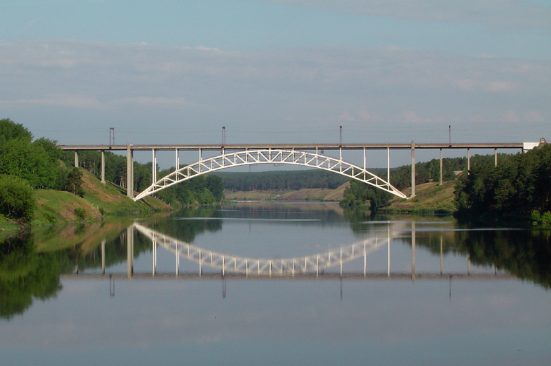
Арочный железнодорожный мост
Monument and historic site · 2.4 km
Уникальный мост через реку Исеть. Автор проекта, Василий Росновский. Спроектированная им конструкция открыла новую страницу в истории...

Здание госпиталя Каменского чугунолитейного завода
Monument and historic site · 2.1 km
4 улица Красных Орлов

Здание казённого заводского училища
Monument and historic site · 3.3 km
17 улица Карла Маркса


Провиантские склады (памятник архитектуры регионального значения)
Monument and historic site · 2.7 km

56 more on the map.
Parks, trails and playgrounds13



1 more on the map.
Restaurants and cafes55

Well&Done
Restaurant · 3.6 km
В пабе гости могут насладиться великолепной европейской кухней, а шеф-повар своим кулинарным мастерством удовлетворит любые капризы...
17 Октябрьская улица, Каменск-Уральский



За хлебушком
Bakery · 2.6 km
104 Октябрьская улица, Каменск-Уральский
Mo-Sa 09:30-20:00
Уральские пельмени
Cafe · 1.7 km
Mo-Su 12:00-24:00; Fr,Sa 12:00-02:00
43 more on the map.
History
Kamensky Zavod was founded in the late 17th century as a settlement next to the cast iron smelting factory and foundry, commissioned on October 15, 1701. For the first two centuries of existence it was known for its cannons.
First schools opened in Kamensk in 1724. The cast iron smelting factory was rebuilt in 1825–1829. Railway traffic started on December 6, 1885. The first library opened in 1899. In 1934, Sinarsky Pipe Works was established. In 1939, Ural Aluminum Factory was established.
Kamensk was granted city status in 1935 and renamed Kamensk-Uralsky in 1940.
From the History section of Kamensk-Uralsky on Wikipedia, under CC BY-SA 4.0.
Where to stay10
Churches and places of worship10
Преображенский мужской монастырь. Церковь Спаса Преображения.
Church · Orthodox · 3.0 km
18 улица Кирова
Часовня Александра Невского
Church · Russian Orthodox · 1.3 km
1Б проспект Победы, Каменск-Уральский
Shopping87
Gas and EV charging26
Schools, colleges and libraries65
Healthcare72
Map of Kamensk-Ural’skiy
250 places. The map loads OpenStreetMap tiles when you open it.
Getting there and nearby towns
Koltsovo International Airport (SVX) is the nearest airport with scheduled flights listed in OpenStreetMap, 79 km away.
- Martyush 3 km west, about 3 min by car
- Pokrovskoye 21 km west, about 21 min by car
- Ust’-Bagaryak 31 km south, about 31 min by car
- Sovkhoznyy 36 km northwest, about 36 min by car
- Baraba 40 km north, about 40 min by car
- Bogdanovich 42 km north, about 42 min by car
- Kataysk 42 km east, about 42 min by car
- Gryaznovskoye 44 km north, about 44 min by car
- Beloyarskiy 50 km northwest, about 50 min by car
- Sukhoy Log 56 km north, about 56 min by car
Drive times are estimates from straight-line distance, not routes.
Local news
Headlines from INDB.
Reviews, tips and questions
Loading what members have shared...
Sources and licences
- GeoNames (CC BY 4.0): population, coordinates, regions and time zone
- OpenStreetMap contributors (ODbL 1.0): places, airports, map data
- Wikidata (CC0 1.0): elevation, founding date, time zone, website, landmarks and historic places
- Wikimedia Commons (see each image): photos
- Wikipedia (CC BY-SA 4.0): overview and history text
Photo credits
- Kamensk-Uralsky photo collage, Evgeniy Smirnov, CC BY-SA 4.0
- 36, Red Eagles Street (Kamensk-Uralsky) 013, Смирнов Евгений, CC BY-SA 4.0
- "Соцгород Трубный", Беляева, Фото Алина, CC BY-SA 4.0
- Bukharev shop 002, Смирнов Евгений, CC BY-SA 4.0
- Church of Intercession of the Theotokos (Kamensk-Uralsky, 1883 - August 2022) - 1, Vyacheslav Bukharov, CC BY-SA 4.0
- Manor caretaker Kamensky plant 008, Смирнов Евгений, CC BY-SA 4.0
- Shop of merchant Gerasimov 002, Смирнов Евгений, CC BY-SA 4.0
- Views of Kamensk-Uralsky (Historical center) (93), Смирнов Евгений, CC BY-SA 4.0
- Grachevs revenue house 001, Смирнов Евгений, CC BY-SA 4.0
- Усадьба купца Косякова, Фото Алина, CC BY-SA 4.0
- Manor of Zyryanovs merchants 001, Смирнов Евгений, CC BY-SA 4.0
- Shop of merchant Molchanov 003, Смирнов Евгений, CC BY-SA 4.0
- Покрова Пресвятой Богородицы2, Леонид Макаров, CC BY-SA 4.0
- Введенская церковь. Село Травянское, Shoonechka, CC BY-SA 4.0
- Здание заводского училища г. Каменск-Уральский, улица Карла Маркса, 17, AviaTor 66.ru, CC BY-SA 3.0
- Warehouses of the Kamensky plant (August 2022) - 5, Vyacheslav Bukharov, CC BY-SA 4.0
- Ул. Красных Орлов 4, Долганов Алексей, CC BY-SA 3.0
- Kamensk Bridge, No machine-readable author provided. DenWiki assumed (based on copyright claims)., CC BY-SA 3.0
- The building of the Kamensk factory school 013, Смирнов Евгений, CC BY-SA 4.0


Page built November 4, 2026. Spotted a mistake? Tell us or suggest a place.