
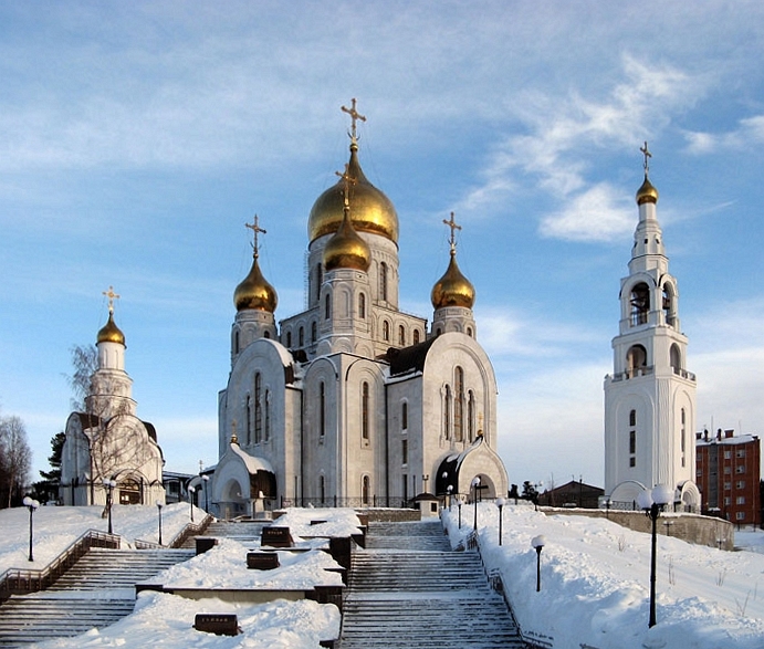


Khanty-Mansiysk, Russia
Ханты-Мансийск
Khanty-Mansiysk is a regional capital of 101,466 people in Khanty-Mansia, Russia, founded in 1931.
Why visit Khanty-Mansiysk
Townapedia lists 34 museums and landmarks, 9 parks and trails, 103 places to eat, 54 places to stay and 8 attractions in and around town.
Highlights include Театр кукол, Red Dragon Bridge, Этнографичекий музей "ТорумМаа" and Этнографический музей под открытым небом "Торум Маа".
Weather in Khanty-Mansiysk
Forecast from MET Norway (CC BY 4.0). Full forecast
About Khanty-Mansiysk
Khanty-Mansiysk (Russian: Ха́нты-Манси́йск; Khanty: Ёмвоҷ, Jomvoćś; Mansi: Абга, Abga) is a city in west-central Siberia in Russia. It lies on the eastern bank of the Irtysh River, 15 kilometers (9.3 mi) from its confluence with the Ob, in the oil-rich region of Western Siberia. Though it is an independent city, Khanty-Mansiysk also functions as the administrative centre of Khanty-Mansiysky District, and the administrative center of Khanty-Mansi Autonomous Okrug–Yugra.
From the Wikipedia article Khanty-Mansiysk (this version), under CC BY-SA 4.0.
Travel tips from other travellers: Khanty-Mansiysk on Wikivoyage (CC BY-SA 4.0).
Things to do8



Yugra State University
School
Education organization in Khanty-Mansiysk, Russia

Museums and landmarks34

Этнографичекий музей "ТорумМаа"
Museum · 0.8 km
30 Комсомольская улица, Ханты-Мансийск
Tu-Fr 10:00-19:00; Sa 11:00-18:00
Этнографический музей под открытым небом "Торум Маа"
Museum · 1.3 km
Экспозиция под открытым небом бюджетного учреждения Ханты-Мансийского автономного округа - Югры "Этнографический музей под открытым...
1 улица Собянина, Ханты-Мансийск
Jun-Sep: 11:00-19:00; Oct-Apr: 10:00-18:00
Галерея-мастерская имени художника Г.С. Райшева
Museum
1 улица Чехова, Ханты-Мансийск

Дом-музей народного художника СССР В.А.Игошина
Monument and historic site
7 улица Лопарева
22 more on the map.
Parks, trails and playgrounds9

Веревочный парк "Каснэ Маа - Земля покорителей"
Sports field and stadium · 1.5 km
3Г улица Механизаторов, Ханты-Мансийск
Mo-Su 11:00-19:00

Сквер лавки премирения.
Park · 3.0 km
Сквер основан в день установки изогнутой лавки для премирения. Так же близкое расположение бара влияет на популярность места в вечернее вермя.

Restaurants and cafes103


Фарфор
Cafe · 4.0 km
26 Заводская улица, Ханты-Мансийск
Mo-Th 10:00-23:00; Fr 10:00-23:59; Sa 11:00-23:59; Su 11:00-23:00

Диван-Сарай
Restaurant · Asian · 0.8 km
Mo-Su 08:00-23:00
Хаят
Cafe · 1.6 km
4 Промышленная улица
Mo-Th 11:00-23:00; Fr-Sa 11:00-01:00; Su 12:00-22:00
Времена Года
Cafe · Cake, Hot Dog, Local, Russian, Breakfast · 0.9 km
Mo-Fr 09:00-17:00; Sa 09:00-15:00
91 more on the map.
History
It was founded in 1930 as a work settlement of Ostyako-Vogulsk (Остяко-Вогульск), around an existing village.
The Church of the Intercession of the Theotokos in Samarovo is an historic church in the city. The original church was built sometime after 1582; in Kungur Chronicles, Cossack Yermak, defeated Khan Kuchum’s army under Tobolsk, after praying for the days. A stone structure was built in 1816, designed by an architect named Shangin. During the years of Soviet regime, the church was plundered. In 1994, excavations were organized and the foundation of the church was discovered. On the Feast of Nativity of the Most Holy Theotokos on September 21, 1996, priest Sergiy Kravtsov held a public prayer and works on restoration of the church of the Intercession of the Most Holy Theotokos started. In 2001, the church was consecrated and Patriarch of Moscow and All Russia, Alexy II of Moscow, visited it the same year.
From the History section of Khanty-Mansiysk on Wikipedia, under CC BY-SA 4.0.
Where to stay54
Гостевой дом "Звездный"
Motel and hotel · 1.6 km
16 Звёздная улица, Ханты-Мансийск
Гостевой дом "На Луговой"
Motel and hotel · 3.5 km
28 Луговая улица, Ханты-Мансийск
Churches and places of worship11
Church of the Intercession of the Most Holy Mother of God in Khanty-Mansiysk
Church · 3.7 km
Кафедральный собор Воскресения Христова
Church · Russian Orthodox
9 улица Гагарина, Ханты-Мансийск
Церковь иконы Божией Матери Знамение
Church · Russian Orthodox · 0.8 km
61/1 улица Калинина, Ханты-Мансийск
Церковь Покрова Пресвятой Богородицы
Church · Russian Orthodox · 3.7 km
277 улица Гагарина, Ханты-Мансийск
Храм в честь святых благоверных князей Петра и Февронии Муромских
Church · 5.2 km
30 Кооперативная улица
Церковь в честь святого праведного отрока Артемия Веркольского
Church · Russian Orthodox · 2.0 km
Shopping84
Gas and EV charging14
Schools, colleges and libraries25
Healthcare52
Map of Khanty-Mansiysk
250 places. The map loads OpenStreetMap tiles when you open it.
Getting there and nearby towns
Khanty-Mansiysk Airport (HMA) is the nearest airport with scheduled flights listed in OpenStreetMap, 4 km away.
Local news
Headlines from INDB.
Reviews, tips and questions
Loading what members have shared...
Sources and licences
- GeoNames (CC BY 4.0): population, coordinates, regions and time zone
- OpenStreetMap contributors (ODbL 1.0): places, airports, map data
- Wikidata (CC0 1.0): elevation, founding date, time zone, website, landmarks and historic places
- Wikimedia Commons (see each image): photos
- Wikipedia (CC BY-SA 4.0): overview and history text
Photo credits
- Khanty-Mansiysk Cathedral, The original uploader was Vow at Russian Wikipedia ., Public domain
- Khanty-Mansiysk, Khanty-Mansi Autonomous Okrug, Russia - panoramio (8), alexandergroshev, CC BY 3.0
- Khanty-Mansiysk, Boris Losev Park, alexandergroshev, CC BY 3.0
- Khanty-Mansiysk, Khanty-Mansi Autonomous Okrug, Russia - panoramio (9), alexandergroshev, CC BY 3.0
- Khanty-Mansiysk, Khanty-Mansi Autonomous Okrug, Russia - panoramio (6), alexandergroshev, CC BY 3.0
- Khanty-Mansiysk, Khanty-Mansi Autonomous Okrug, Russia - panoramio (7), alexandergroshev, CC BY 3.0
- Red dragon bridge 01, ФГБУ "ИНФОРМАВТОДОР", CC BY 4.0
- Ugrasu glavnii korpus, Crystalline lens, CC BY-SA 4.0
- Temple of Veil of the Most Holy Mother of God, Милютин Станислав Викторович, Public domain
- Fomitopsis pinicola 96019292, Tatiana, CC BY 4.0
- Югорский государственный университет, Scherbakovag, Public domain
- Fomitopsis pinicola 98214086, Tatiana, CC BY 4.0
- Fomitopsis pinicola 99172143, Tatiana, CC BY 4.0
- Ханты-Мансийская мозаика - panoramio, Alkhimov Maxim, CC BY 3.0
- Peduch, Agishev, CC BY-SA 4.0
- Самаровский чугас Июнь 2018, Malikov Vladimir, CC BY-SA 4.0
- Ханты-Мансийск, собор Воскресения Христова, Милютин Станислав Викторович, Public domain
- Coprinopsis atramentaria 95751064, Viktoria Bilous, CC BY 4.0
- Gymnopilus penetrans 95750295, Viktoria Bilous, CC BY 4.0
- Pholiota gummosa 95748798, Viktoria Bilous, CC BY 4.0
- Pholiota gummosa 95748776, Viktoria Bilous, CC BY 4.0
- Leccinum scabrum 95748897, Viktoria Bilous, CC BY 4.0
- Phanerochaete sanguinea 100662767, Виктория Билоус, CC BY 4.0
- Datronia mollis 100662741, Виктория Билоус, CC BY 4.0
- Clitocybe nebularis 98216197, Tatiana, CC BY 4.0
- Fomitopsis pinicola 98917556, Viktoria Bilous, CC BY 4.0
- Самаровский чугас мост, Сам Чугас, CC BY-SA 4.0
- Самаровский чугас Июнь 2018 2, Malikov Vladimir, CC BY-SA 4.0
- Educational session on Wikipedia on the forum - Community. Khanty -Mansiysk, May 2018 02, JukoFF, CC BY-SA 4.0
- Educational session on Wikipedia on the forum - Community. Khanty -Mansiysk, May 2018 03, JukoFF, CC BY-SA 4.0
- Educational session on Wikipedia on the forum - Community. Khanty -Mansiysk, May 2018 01, JukoFF, CC BY-SA 4.0
- Educational session on Wikipedia on the forum - Community. Khanty -Mansiysk, May 2018 05, JukoFF, CC BY-SA 4.0
- Educational session on Wikipedia on the forum - Community. Khanty -Mansiysk, May 2018 04, JukoFF, CC BY-SA 4.0
- Educational session on Wikipedia on the forum - Community. Khanty -Mansiysk, May 2018 06, JukoFF, CC BY-SA 4.0
- Ледяные скульптуры - panoramio (1), Oldayn, CC BY 3.0
- Marasmius epiphyllus 96021746, Tatiana, CC BY 4.0
- Marasmius epiphyllus 96021723, Tatiana, CC BY 4.0
- Самаровский чугас, Сам Чугас, CC BY-SA 4.0
- Spathularia flavida 80317951, Viktoria Bilous, CC BY 4.0
- Spathularia flavida 80317971, Viktoria Bilous, CC BY 4.0


Page built November 4, 2026. Spotted a mistake? Tell us or suggest a place.