
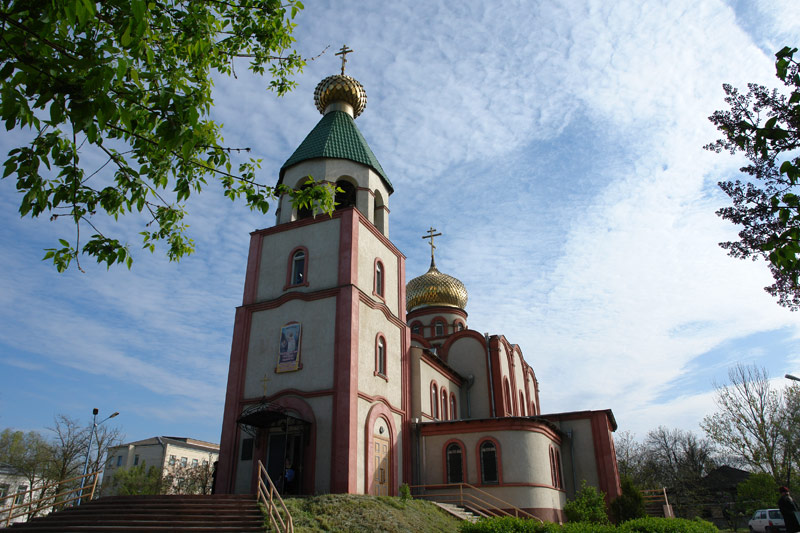


Kizlyar, Russia
Кизляр
Kizlyar is a town of 50,564 people in Dagestan, Russia, founded in 1735.
Why visit Kizlyar
Townapedia lists 17 museums and landmarks, 7 parks and trails, 22 places to eat, 4 places to stay and 3 attractions in and around town.
Highlights include Darman's park.
Weather in Kizlyar
Forecast from MET Norway (CC BY 4.0). Full forecast
About Kizlyar
Kizlyar (Russian: Кизля́р; Avar: Гъизляр; Kumyk: Къызлар, Qızlar) is a town in the Republic of Dagestan, Russia, located on the border with the Chechen Republic in the delta of the Terek River 221 kilometers (137 mi) northwest of Makhachkala, the capital of the republic. As of the 2010 Census, its population was 48,984.
From the Wikipedia article Kizlyar (this version), under CC BY-SA 4.0.
Travel tips from other travellers: Kizlyar on Wikivoyage (CC BY-SA 4.0).
Things to do3


Museums and landmarks17


5 more on the map.
Parks, trails and playgrounds7



Restaurants and cafes22



10 more on the map.
History
The first documented reference to Kizlyar dates back to 1609, although some historians associate the place with Samandar, the 8th-century capital of Khazaria. In 1735 the Russian government built a fortress in Kizlyar and laid foundations for the Caucasus fortified borderline. In the 18th and 19th centuries, Kizlyar operated as one of the trading posts between Russia and the Middle East and Central Asia. During this period, the population was largely Armenian and Russian. In 1796 2,800 Armenians and 1,000 Russians lived in Kizlyar. During the Russian Empire, the settlement was the administrative capital of the Kizlyarsky Otdel of the Terek Oblast. In 1942 the Germans briefly took Kizylar (Kizjlar).
In January 1996 Chechen separatists raided the local airbase in the course of the Kizlyar raid, which claimed the lives of seventy-eight Russian soldiers.
On February 18, 2018, five people were killed and five wounded after a shooting attack took place outside a Christian church in Kizlyar. Police killed the attacker in a shootout.
From the History section of Kizlyar on Wikipedia, under CC BY-SA 4.0.
Where to stay4
Churches and places of worship19
Собор Георгия Победоносца
Church · Russian Orthodox · 1.0 km
14А Советская улица, Кизляр
Shopping12
Gas and EV charging5
Schools, colleges and libraries31
Healthcare15
Map of Kizlyar
135 places. The map loads OpenStreetMap tiles when you open it.
Getting there and nearby towns
Grozny Airport (GRV) is the nearest airport with scheduled flights listed in OpenStreetMap, 97 km away.
- Pervomayskoye 8 km north, about 8 min by car
- Komsomol’skiy 15 km north, about 15 min by car
- Kargalinskaya 22 km southwest, about 22 min by car
- Babayurt 28 km south, about 28 min by car
- Tarumovka 29 km northwest, about 29 min by car
- Khamamatyurt 31 km southwest, about 31 min by car
- Adil’-Yangiyurt 33 km south, about 33 min by car
- Utsmiyurt 40 km southwest, about 40 min by car
- Khasavyurt 67 km south, about 1 h by car
- Kizilyurt 73 km south, about 1 h 15 min by car
Drive times are estimates from straight-line distance, not routes.
Local news
Headlines from INDB.
Reviews, tips and questions
Loading what members have shared...
Sources and licences
- GeoNames (CC BY 4.0): population, coordinates, regions and time zone
- OpenStreetMap contributors (ODbL 1.0): places, airports, map data
- Wikidata (CC0 1.0): elevation, founding date, time zone, website
- Wikimedia Commons (see each image): photos
- Wikipedia (CC BY-SA 4.0): overview and history text
Photo credits
- Свято-Георгиевский храм г. Кизляр, Аксянов, CC BY-SA 3.0
- Крестовоздвиженский храм в Кизляре, Tamdikatamdikabalebale, CC BY-SA 4.0
- Женский монастырь в Кизляре, Tamdikatamdikabalebale, CC BY-SA 4.0
- Фрагменты керамики Некрасовского городища, Tamdikatamdikabalebale, CC BY-SA 4.0
- Посёлок им. Кирова, Кизлярский р-н, Tamdikatamdikabalebale, CC BY-SA 4.0
- Виноград ККЗ, Василий Петрович ом, CC BY-SA 4.0
- Russian cognac "Saradzhev", Василий Петрович ом, CC BY-SA 4.0
- Пос. им. Кирова, Дагестан, Tamdikatamdikabalebale, CC BY-SA 4.0
- Один из производственных цехов ККЗ, Kizlyar Brandy Factory, CC BY 2.0
- Один из производственных цехов, Kizlyar Brandy Factory, CC BY 2.0
- ККЗ 2018 (6), Василий Петрович ом, CC BY-SA 4.0
- ККЗ 2018 (1), Василий Петрович ом, CC BY-SA 4.0
- Cognac Russian "Saradzhev", Василий Петрович ом, CC BY-SA 4.0
- Бутылки ККЗ (1), Василий Петрович ом, CC BY-SA 4.0
- ККЗ 2018 (7), Василий Петрович ом, CC BY-SA 4.0
- ККЗ 2018 (5), Василий Петрович ом, CC BY-SA 4.0
- ККЗ 2018 (4), Василий Петрович ом, CC BY-SA 4.0
- Памятник Багратиону на ККЗ 2018 (5), Василий Петрович ом, CC BY-SA 4.0
- Памятник Багратиону на ККЗ 2018 (1), Василий Петрович ом, CC BY-SA 4.0
- ККЗ 2018 (3), Василий Петрович ом, CC BY-SA 4.0
- ККЗ 2018 (2), Василий Петрович ом, CC BY-SA 4.0
- Памятник Багратиону на ККЗ 2018 (2), Василий Петрович ом, CC BY-SA 4.0
- Памятник Багратиону на ККЗ 2018 (3), Василий Петрович ом, CC BY-SA 4.0
- Старые коньяки Кизлярского коньячного завода, Zurabomarov, CC BY-SA 4.0
- Бутылки ККЗ (2), Василий Петрович ом, CC BY-SA 4.0
- Багратион ККЗ табличка, Василий Петрович ом, CC BY-SA 4.0
- «Золотая пальма»., Zurabomarov, CC BY-SA 4.0
- Производственный цех ККЗ, Kizlyar Brandy Factory, CC BY 2.0
- ККЗ цех, Kizlyar Brandy Factory, CC BY 2.0
- Первый производственный цех ККЗ, Василий Петрович ом, CC BY-SA 4.0
- Первый производственный цех Кизлярского коньячного завода, Василий Петрович ом, CC BY-SA 4.0
- Дубовая бочка для выдержки коньяков Кизлярского коньячного завода, Василий Петрович ом, CC BY-SA 4.0
- Старый купажный цех ККЗ, построенный в 1885 году, Василий Петрович ом, CC BY-SA 4.0
- Бочки из горного кавказского дуба в ККЗ, Василий Петрович ом, CC BY-SA 4.0
- Дубовые бочки для выдержки коньяков ККЗ, Василий Петрович ом, CC BY-SA 4.0
- Старый купажный цех, Василий Петрович ом, CC BY-SA 4.0
- Первый производственный цех ККЗ, 1885 год, Василий Петрович ом, CC BY-SA 4.0
- Купажный цех ККЗ, построенный в 1885 году, Василий Петрович ом, CC BY-SA 4.0
- Купажный цех ККЗ, Василий Петрович ом, CC BY-SA 4.0
- Бочки из горного кавказского дуба, Василий Петрович ом, CC BY-SA 4.0


Page built November 4, 2026. Spotted a mistake? Tell us or suggest a place.