
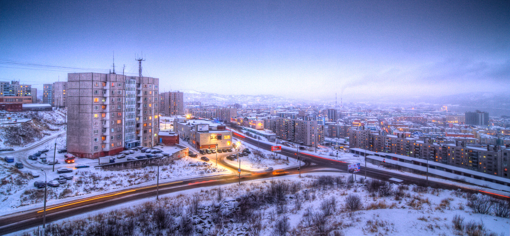


Murmansk, Russia
Мурманск
Murmansk is a regional capital of 295,374 people in Murmansk, Russia, founded in October 4, 1916.
Why visit Murmansk
Townapedia lists 76 museums and landmarks, 14 parks and trails, 160 places to eat, 26 places to stay and 10 attractions in and around town.
Highlights include Мурманский областной драматический театр, Mirage, Мурманский областной краеведческий музей and Мурманский областной художественный музей.
Weather in Murmansk
Forecast from MET Norway (CC BY 4.0). Full forecast
About Murmansk
Murmansk (Russian: Мурманск) is the administrative center and largest city of Murmansk Oblast in the far northwest part of Russia. It is a major port city and is the world's most populous city north of the Arctic Circle. It sits on both slopes and banks of Kola Bay, with its bulk on the east bank of the inlet. The bay, a modest fjord, is an estuarine inlet of the Barents Sea.
From the Wikipedia article Murmansk (this version), under CC BY-SA 4.0.
Travel tips from other travellers: Murmansk on Wikivoyage (CC BY-SA 4.0).
Things to do10




Monument to the Victims of the Intervention
Monument and historic site · 1.1 km
Monument in Russia
Мурманский областной театр кукол
Cinema and theater · 1.7 km
Бывший Дом Офицеров Мурманского Гарнизона
27 проспект Ленина, Мурманск

Museums and landmarks76

Мурманский областной краеведческий музей
Museum · 0.9 km
90 проспект Ленина, Мурманск
Tu-Su 11:00-20:00

Мурманский областной художественный музей
Museum · 1.1 km
13 улица Коминтерна, Мурманск
We-Su 11:00-18:00



Memorial to Defenders of the Soviet Arctic during the Great Patriotic War
Monument and historic site · 3.0 km
World War II memorial in Russia
Container Hall
Museum · 2.1 km
22 улица Генералова
Tu-Fr 16:00-20:00; Sa-Su 14:00-21:00

Аллея писателей
Monument and historic site
Бюсты Н. М. Рубцову, В. А. Смирнову, В. С. Пикулю, В. С. Маслову
Английское кладбище
Monument and historic site · 1.1 km
Кладбище английских интервентов 1919 года. Перенесено с улицы Буркова в 1930 году
В честь 75-летия научно-промысловых исследований Баренцева моря
Monument and historic site · 1.4 km
В честь 75-летия научно-промысловых исследований Баренцева моря
64 more on the map.
Parks, trails and playgrounds14



Детская спортивная площадка
Playground · 1.5 km
Баскетбольное кольцо, окружено высокой сеткой, полимерное напольное покрытие


2 more on the map.
Restaurants and cafes160

Moroshka
Cafe · Ramen, International, Cake, Tea, Coffee Shop, Noodles, Russian, Chicken · 1.0 km
13 улица Егорова
Mo-Fr 10:00-22:00; Sa-Su 11:00-22:00


Chop BBQ
Restaurant · Barbecue, Burger, Italian, Seafood, Fish, International, Salad, Dessert, Soup, European · 1.4 km
10А улица Полярные Зори, Мурманск
Mo,Tu,We,Th,Su 12:00-23:00; Fr-Sa 12:00-00:00;

148 more on the map.
History
In 1915, World War I needs led to the construction of the northern part of the Kirov Railway: a railroad from Petrozavodsk to an ice-free location on the Murman Coast in the Russian Arctic, to which Russia's allies shipped military supplies.
The terminus became known as the Murman station and soon boasted a port, a naval base, and an adjacent settlement with a population that quickly grew in size and soon surpassed the nearby towns of Alexandrovsk and Kola.
On June 29 [O.S. July 12], 1916, Russian Transport Minister Alexander Trepov petitioned to grant urban status to the railway settlement. On July 6 [O.S. July 19], 1916, the petition was approved and the town was named Romanov-on-Murman (Рома́нов-на-Му́рмане, Romanov-na-Murmane), after the Imperial Russian dynasty, the Romanovs.
On September 21 [O.S. October 4], 1916, the official ceremony was performed, and the date is now considered the official date of the city's foundation. After the February Revolution of March 1917, on April 3 [O.S. April 16], 1917, the town was given its present name.
In the winter of 1917 the British North Russia Squadron under Rear Admiral Thomas Kemp was based at Murmansk.
From 1918 to 1920, during the Russian Civil War, the town was occupied by the Western powers, who had been allied in World War I, and was also controlled by White Army forces.
From the History section of Murmansk on Wikipedia, under CC BY-SA 4.0.
Where to stay26
Churches and places of worship12
Церковь Спаса на Водах
Church · Orthodox · 2.2 km
1 проспект Героев Североморцев, Мурманск
Церковь Всех Святых
Church · Russian Orthodox · 0.9 km
7А Скальная улица, Мурманск
Спасо-Преображенский морской кафедральный собор
Church · Orthodox · 2.2 km
1 к2 проспект Героев Североморцев, Мурманск
Церковь Святого Великомученика Пантелеймона
Church · Orthodox · 1.5 km
7А Терский переулок, Мурманск
Закладной крест часовни Святого Николая покровителя Мурманска
Church · Orthodox · 0.8 km
Церковь Христиан Веры Евангельской на Мурмане
Church · 1.3 km
10Б улица Полярные Зори, Мурманск
Shopping92
Gas and EV charging6
Schools, colleges and libraries66
Мурманский арктический университет
School · 0.9 km
15 улица Егорова, Мурманск
Healthcare83
Map of Murmansk
250 places. The map loads OpenStreetMap tiles when you open it.
Getting there and nearby towns
Murmansk (MMK) is the nearest airport with scheduled flights listed in OpenStreetMap, 25 km away.
- Abram Mys 3 km west, about 3 min by car
- Roslyakovo 9 km northeast, about 9 min by car
- Kola 10 km south, about 10 min by car
- Safonovo 13 km northeast, about 13 min by car
- Molochnyy 13 km south, about 13 min by car
- Severomorsk 17 km northeast, about 17 min by car
- Murmashi 20 km southwest, about 20 min by car
- Snezhnogorsk 26 km north, about 26 min by car
- Shonguy 25 km south, about 25 min by car
- Polyarnyy 29 km northeast, about 29 min by car
Drive times are estimates from straight-line distance, not routes.
Local news
Headlines from INDB.
Reviews, tips and questions
Loading what members have shared...
Sources and licences
- GeoNames (CC BY 4.0): population, coordinates, regions and time zone
- OpenStreetMap contributors (ODbL 1.0): places, airports, map data
- Wikidata (CC0 1.0): elevation, founding date, time zone, website, landmarks and historic places
- Wikimedia Commons (see each image): photos
- Wikipedia (CC BY-SA 4.0): overview and history text
Photo credits
- Murmansk, Tom Thiel, CC BY 2.0
- Murmansk trolleybus 124 2022-05 Polyarnye Zori street, Svetlov Artem, CC0
- Murmansk Skalnyi quarter 2022-05-09 2, Svetlov Artem, CC0
- UEMI-50 amplifier with ASEMI-50 loudspeaker in Murmansk, 2016, FingerWiki, CC BY-SA 4.0
- Oktyabrskiy okrug, Murmansk, Murmanskaya oblast', Russia - panoramio (1), Konstantin Mednikov, CC BY-SA 3.0
- Murmansk Starostina street 2022-05, Svetlov Artem, CC0
- Maritime Bank office in Murmansk, 2017, FingerWiki, CC BY-SA 4.0
- Murmansk Center of Scientific and Technical Information, 2017, FingerWiki, CC BY 4.0
- Murmansk Skalnyi quarter 2022-05-09 5, Svetlov Artem, CC0
- Murmansk Skalnyi quarter 2022-05-09 4, Svetlov Artem, CC0
- Murmansk Skalnyi quarter 2022-05-09 6, Svetlov Artem, CC0
- Murmansk Skalnyi quarter 2022-05-09, Svetlov Artem, CC0
- Открытая библиотека 2018-05-08, Murmansk, MGOUNB 3, JukoFF, CC BY-SA 4.0
- Открытая библиотека 2018-05-08, Murmansk, MGOUNB 1, JukoFF, CC BY-SA 4.0
- Открытая библиотека 2018-05-08, Murmansk, MGOUNB 2, JukoFF, CC BY-SA 4.0
- Открытая библиотека 2018-05-08, Murmansk, MGOUNB, JukoFF, CC BY-SA 4.0
- Murmansk Marksa street 2022-05, Svetlov Artem, CC0
- Murmansk Profsoyzov street, Svetlov Artem, CC0
- Card catalogs in Murmansk Regional Scientific Library, 2018, FingerWiki, CC BY-SA 4.0
- Murmansk Bridge, Superchango, CC BY 2.0
- Алёша зимой, Ted.ns, CC BY-SA 4.0
- Памятник Жертвам интервенции 2, Insider, CC BY-SA 4.0
- Lenin icebreaker, Palefire at English Wikipedia, CC BY-SA 3.0
- Azimut Hotel Murmansk, ООО «АЗИМУТ Хотелс Компани», CC BY-SA 4.0
- МГТУ, kkv1970, CC BY-SA 3.0
- Oblastnoi dramteatr murmansk, Azalaza, CC BY-SA 3.0
- Краеведческий музей Мурманска 5, Insider, CC BY-SA 3.0
- Museum Murman 2, Сорокин Андрей Александрович, CC BY-SA 3.0
- Hram Spasa-Na-Vodah Murmansk 01, Maarten (Superchango), CC BY 2.0
- Центральный стадион профсоюзов зимой, Insider, CC BY-SA 3.0
- Ледокол ЛЕНИН, FynjyRepmvby, CC BY-SA 4.0
- Museum Murman, Сорокин Андрей Александрович, CC BY-SA 3.0
- Мурманск (49527940477), Sergei Gussev, CC BY 2.0
- Мурманск (49527716876), Sergei Gussev, CC BY 2.0
- Ул. Капитана Буркова возле дома 45 (справа не видно) Июнь 2011 - panoramio, Солнечный Фрукт, CC BY 3.0
- Медико-санитарная часть УВД Мурманской области - panoramio, Николай Максимович, CC BY 3.0
- Скальный 2022-05, Svetlov Artem, CC BY-SA 4.0
- Деревянная мостовая у парка атракционов в Мурманске, Insider, CC BY-SA 4.0
- Вид на микрорайон Скальный и Мурманск, Терский берег, CC BY-SA 3.0
- Bumper cars, Tom Thiel, CC BY 2.0


Page built November 4, 2026. Spotted a mistake? Tell us or suggest a place.