
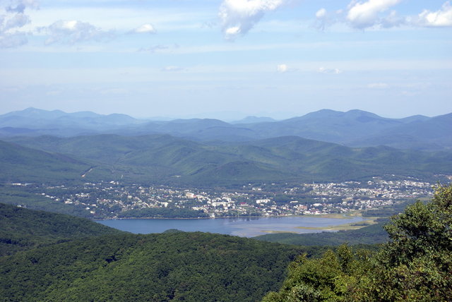

Ol’ga, Russia
Ольга
Ol’ga is a town of 4,328 people in Primorye, Russia, founded in 1858.
Why visit Ol’ga
Townapedia lists 1 place to eat in and around town.
Weather in Ol’ga
Forecast from MET Norway (CC BY 4.0). Full forecast
About Ol’ga
Olga (Russian: О́льга) is an urban locality (an urban-type settlement) and the administrative center of Olginsky District of Primorsky Krai, Russia, located on the Olga Bay of the Sea of Japan, 240 kilometers (150 mi) northeast of Nakhodka. Population: 4,026 (2010 census); 4,453 (2002 census); 4,802 (1989 Soviet census).
From the Wikipedia article Olga, Russia (this version), under CC BY-SA 4.0.
Restaurants and cafes1

Ёшкин Кот
Cafe · Coffee Shop, Russian
Tu,Mo,We-Fr 09:00-19:00; Su,Sa 09:00-19:00
Gas and EV charging1
Schools, colleges and libraries3

Healthcare3


History
During the Balhae Kingdom period, a town called Anju was founded near present-day Olga on the shores of Olga Bay.
The Russian military post of Olga was established in 1858, several months after the region passed to Russia under the terms of the Treaty of Aigun. It was named after St. Olga. In the 19th century, the settlement had a significant Chinese minority. The town's name is similar to that of the eldest daughter of Nicholas II.
From the History section of Olga, Russia on Wikipedia, under CC BY-SA 4.0.
Map of Ol’ga
8 places. The map loads OpenStreetMap tiles when you open it.
Getting there and nearby towns
Kavalerovo Airport (KVR) is the nearest airport with scheduled flights listed in OpenStreetMap, 62 km away.
- Gornorechenskiy 59 km north, about 59 min by car
- Kavalerovo 62 km north, about 1 h by car
- Rudnyy 65 km northwest, about 1 h by car
- Rudnaya Pristan’ 80 km northeast, about 1 h 15 min by car
Drive times are estimates from straight-line distance, not routes.
Local news
Headlines from INDB.
Reviews, tips and questions
Loading what members have shared...
Sources and licences
- GeoNames (CC BY 4.0): population, coordinates, regions and time zone
- OpenStreetMap contributors (ODbL 1.0): places, airports, map data
- Wikidata (CC0 1.0): elevation, founding date, time zone, website
- Wikimedia Commons (see each image): photos
- Wikipedia (CC BY-SA 4.0): overview and history text
Photo credits
- View of Olga, mishaKa, CC BY-SA 3.0
Page built November 4, 2026. Spotted a mistake? Tell us or suggest a place.