


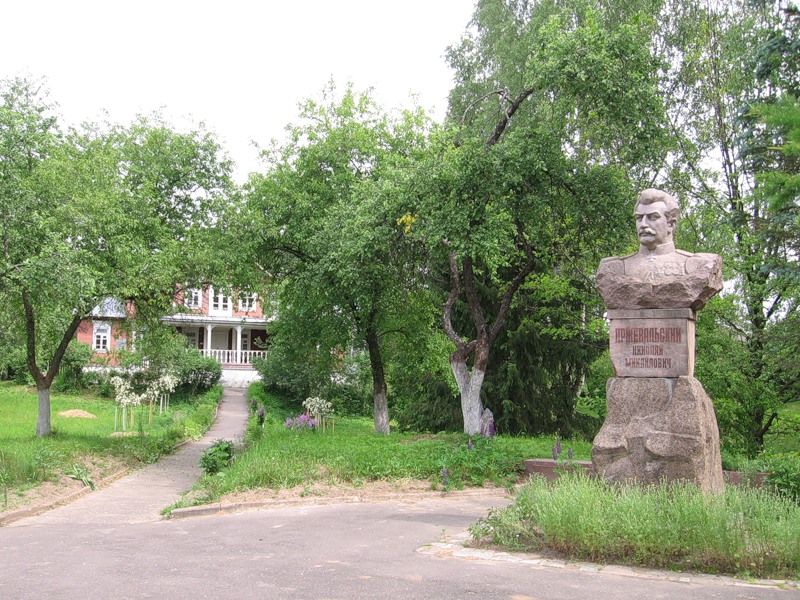

Przheval’skoye, Russia
Пржевальское
Przheval’skoye is a town of 1,000 people in Smolensk Oblast, Russia.
Why visit Przheval’skoye
Townapedia lists 34 museums and landmarks, 1 park or trail, 3 places to eat, 7 places to stay and 23 attractions in and around town.
Weather in Przheval’skoye
Forecast from MET Norway (CC BY 4.0). Full forecast
About Przheval’skoye
Przhevalskoye (Russian: Пржева́льское) is an urban locality (a settlement) in Demidovsky District of Smolensk Oblast, Russia, located in the northwestern part of the oblast, on Lake Sapsho, northeast of the town of Demidov, the administrative center of the district. It is a terminus of the Demidov-Przhevalskoye Highway. As of the 2010 Census, its population was 1,683.
From the Wikipedia article Przhevalskoye (this version), under CC BY-SA 4.0.
Things to do23

11 more on the map.
Museums and landmarks34


Стоянка эпоха неолита
Monument and historic site · 1.6 km
Озеро Сапшо, остров Чернецкий
Братское кладбище №4 – монумент и захоронение 2728 воинов
Monument and historic site
П. Пржевальское
Братское кладбище №5: монумент и братское захоронение останков свыше 300 воинов
Monument and historic site
П. Пржевальское
Курганный могильник 1 (42 насыпи) VIII – X, XI – XIII вв.
Monument and historic site · 1.0 km
П. Пржевальское
Курганный могильник 2 (17 насыпей) VIII – X, XI – XIII вв.
Monument and historic site
П. Пржевальское
Курганный могильник 3 (8 насыпей) VIII – X, XI – XIII вв.
Monument and historic site
П. Пржевальское
Могила Героя Советского Союза М.Л. Гуревича
Monument and historic site
П. Пржевальское
22 more on the map.
Parks, trails and playgrounds1

Restaurants and cafes3

History
The village of Sloboda was first mentioned in 1724 in connection with the building of the church, although the place had been inhabited long before that. Archeologists found ceramic products of the 4th or 3rd millennium BCE. In the 4th-8th centuries, it was inhabited by the Krivichs. People also lived in these lands at later times. Along the rivers and lakes (including Lake Sapsho), there was the trade route from the Varangians to the Greeks, and not so far away there was the second big city of the Principality of Smolensk called Verzhavsk (Вержавск). In the 19th century, it was an outlying area with little economic activity. It was the reason why Nikolay Przhevalsky bought an estate here in 1881. In the middle of the 20th century, Przhevalskoye-Sloboda became famous during World War II for its partisan defenders. From September 1942 to September 1943, the front line ran through the village. Almost all buildings were burnt. The partisans' staff was located in the partly ruined church.
From the History section of Przhevalskoye on Wikipedia, under CC BY-SA 4.0.
Where to stay7
Churches and places of worship1
Церковь Вознесения Господнего, XVIII в. (1782 г.)
Church · Orthodox · 0.9 km
32 улица Пржевальского
Shopping2
Healthcare2
Map of Przheval’skoye
73 places. The map loads OpenStreetMap tiles when you open it.
Getting there and nearby towns
Smolensk South Tikhvinka Airport (LNX) is the nearest airport with scheduled flights listed in OpenStreetMap, 86 km away.
- Demidov 34 km southwest, about 34 min by car
- Ozërnyy 36 km east, about 36 min by car
- Velizh 42 km west, about 42 min by car
- Zharkovskiy 46 km northeast, about 46 min by car
- Dukhovshchina 50 km southeast, about 50 min by car
- Yartsevo 73 km southeast, about 1 h 15 min by car
- Usvyaty 74 km west, about 1 h 15 min by car
- Pechersk 74 km south, about 1 h 15 min by car
- Rudnya 79 km southwest, about 1 h 15 min by car
- Smolensk 82 km south, about 1 h 15 min by car
Drive times are estimates from straight-line distance, not routes.
Local news
Headlines from INDB.
Reviews, tips and questions
Loading what members have shared...
Sources and licences
- GeoNames (CC BY 4.0): population, coordinates, regions and time zone
- OpenStreetMap contributors (ODbL 1.0): places, airports, map data
- Wikidata (CC0 1.0): elevation, founding date, time zone, website
- Wikimedia Commons (see each image): photos
- Wikipedia (CC BY-SA 4.0): overview and history text
Photo credits
- Администрация п Пржевальское, Denis Bisteinoff, CC BY 3.0
- Vid iz Okna Sanatory Przhevalskogo, Niklitov, CC BY-SA 4.0
- Sapsho Bereg Sanatory, Niklitov, CC BY-SA 4.0
- Sapsho Bereg, Niklitov, CC BY-SA 4.0
- Пржевальское. Музей-усадьба, TatianaNP, CC BY-SA 3.0
- Музей-усадьба Н. М. Пржевальского., TatianaNP, CC BY-SA 3.0
- Ostrov Dlinny Sapsho, Niklitov, CC BY-SA 4.0
- Eurasian Woodcock Scolopax rusticola, Smolenskoye Poozer'e, Russia 207906425, dmitry_tikhonov, CC0
- Eurasian Woodcock Scolopax rusticola, Smolenskoye Poozer'e, Russia 207906517, dmitry_tikhonov, CC0
- На заправке - panoramio, Machmood, CC BY 3.0


Page built November 4, 2026. Spotted a mistake? Tell us or suggest a place.