


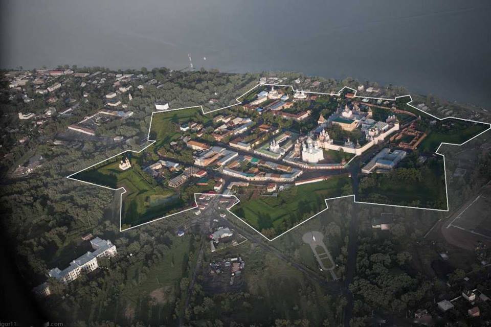

Rostov Veliky, Russia
Ростов Великий
Rostov Veliky is a town of 31,039 people in Yaroslavl Oblast, Russia.
Why visit Rostov Veliky
Townapedia lists 34 museums and landmarks, 6 parks and trails, 50 places to eat, 22 places to stay and 6 attractions in and around town.
Highlights include Museum-Preserve «Rostov Kremlin», Rostov kremlin, Ростовский кремль and Царевна-лягушка.
Weather in Rostov Veliky
Forecast from MET Norway (CC BY 4.0). Full forecast
About Rostov Veliky
Rostov Veliky (Russian: Ростов Великий, [rɐˈstof vʲɪˈlʲikʲɪj], lit. 'Rostov the Great') is a town and the administrative center of Rostovsky District in Yaroslavl Oblast, Russia. It is one of the oldest towns in the country and a tourist center of the Golden Ring.
From the Wikipedia article Rostov Veliky (this version), under CC BY-SA 4.0.
Travel tips from other travellers: Rostov Veliky on Wikivoyage (CC BY-SA 4.0).
Things to do6

Museum-Preserve «Rostov Kremlin»
Monument and historic site · 0.8 km
Museum in Rostov, Yaroslavl Oblast, Russia

Rostov kremlin
Monument and historic site · 0.7 km
Historic site in Rostov, Russia


Spaso-Yakovlevsky Monastery
Monument and historic site · 2.2 km
Eastern Orthodox monastery


Museums and landmarks34

Экспозиция "Русское и западноевропейское барокко"
Museum · 0.7 km
В экспозиции представлена коллекция произведений иконописи, скульптуры и декоративно-прикладного искусства XVII-XVIII вв. из собрания...
Дом ремесел
Museum · 0.9 km
16 2-й проезд Толстовской набережной
Конюшенный двор
Monument and historic site · 0.8 km
XVII век
1 улица Каменный Мост
22 more on the map.
Parks, trails and playgrounds6




Restaurants and cafes50


Василько
Cafe · Russian · 0.7 km
1/2 Соборная площадь
Mo-Fr 11:00-17:00; Sa 11:00-21:00; Su 11:00-19:00
Веселый кабанчик
Cafe · Russian
49 Окружная улица
Su, We-Th 13:00-23:00; Fr 13:00-01:00; Sa 13:00-02:00
Алёша Попович
Cafe
1 улица Карла Маркса
Mo-Fr,Su 09:00-19:00; Sa 09:00-20:00

Байкер хаус «Олень»
Bar and pub · European,caucasian · 0.9 km
Mo-Fr 17:00-23:00; Sa,Su 15:00-23:00
Pokrovskie vorota
Restaurant · 1.1 km
Mo-Su 10:00-22:00; Fr,Sa 10:00-23:00

38 more on the map.
History
Rostov was preceded by Sarskoye Gorodishche, which some scholars interpret as the capital of the Meryans, a Finnic tribe, while others believe it was an important Viking trade enclave and fortress guarding the Volga trade route. The Meryans inhabited the area from the 7th to 10th centuries, and traces of craft activities from this period have been found on the site.
The town is first mentioned in the Primary Chronicle under the year 862 as one of the towns subject to Rurik. Continuous urban development can be traced from the 980s. The town's earliest fortifications, dating to the 10th–13th centuries, have not survived, although a moat and rampart likely existed along the town's perimeter.
In the late 10th and 11th centuries, Rostov was often assigned to one of the sons of the Kievan grand princes, including Yaroslav Vladimirovich and Boris Vladimirovich. From the late 11th to the mid-12th century, Rostov was the capital of the Rostov-Suzdal principality, and it subsequently became part of the Grand Principality of Vladimir, a major Russian principality. It became the capital of the Principality of Rostov in 1207–1208. However, during the Mongol conquest, Rostov was seized by the Mongols in 1238 after offering no resistance, seemingly leaving the town undamaged.
From the History section of Rostov Veliky on Wikipedia, under CC BY-SA 4.0.
Where to stay22
Churches and places of worship26
Собор Успения Пресвятой Богородицы
Church · Russian Orthodox · 0.6 km
Церковь Покрова Пресвятой Богородицы
Church · Orthodox · 1.2 km
31 Ленинская улица, Ростов
Церковь Толгской иконы Пресвятой Богородицы
Church · Orthodox · 0.7 km
улица Декабристов
Петровский монастырь
Church · Russian Orthodox · 3.1 km
13 Ленинградская улица, Ростов Великий
Собор Богоявления Господня
Church · Russian Orthodox · 2.4 km
32 Желябовская улица, Ростов
Церковь Державной иконы Божией Матери
Church · Russian Orthodox · 2.2 km
57 Ярославское шоссе
Церковь Димитрия, митрополита Ростовского
Church · Russian Orthodox · 2.2 km
44 Малая Яковлевская улица
Церковь Николая Чудотворца
Church · Russian Orthodox · 0.9 km
14В Советская площадь
Shopping46
Gas and EV charging8
Schools, colleges and libraries11
Healthcare21
Map of Rostov Veliky
230 places. The map loads OpenStreetMap tiles when you open it.
Getting there and nearby towns
Tunoshna Airport (IAR) is the nearest airport with scheduled flights listed in OpenStreetMap, 61 km away.
- Ishnya 3 km west, about 3 min by car
- Porech’ye-Rybnoye 10 km south, about 10 min by car
- Semibratovo 15 km northeast, about 15 min by car
- Borisoglebskiy 17 km northwest, about 17 min by car
- Petrovsk 22 km southwest, about 22 min by car
- Gavrilov-Yam 29 km northeast, about 29 min by car
- Il’inskoye-Khovanskoye 32 km southeast, about 32 min by car
- Yaroslavl 56 km northeast, about 56 min by car
- Nerekhta 76 km northeast, about 1 h 15 min by car
- Yur’yev-Pol’skiy 78 km south, about 1 h 15 min by car
Drive times are estimates from straight-line distance, not routes.
Local news
Headlines from INDB.
Reviews, tips and questions
Loading what members have shared...
Sources and licences
- GeoNames (CC BY 4.0): population, coordinates, regions and time zone
- OpenStreetMap contributors (ODbL 1.0): places, airports, map data
- Wikidata (CC0 1.0): elevation, founding date, time zone, website, landmarks and historic places
- Wikimedia Commons (see each image): photos
- Wikipedia (CC BY-SA 4.0): overview and history text
Photo credits
- Вид на Спасо-Яковлевский монастырь, Swetozar1, CC BY-SA 4.0
- Rostov Church on Ishnya S88, Ludvig14, CC BY-SA 4.0
- Rostov Kremlin 9667, G.-U. Tolkiehn, CC BY 2.5
- Ростов.Кремль.1, Navigator-1955, CC BY-SA 4.0
- Fortresskremlin, Sergey Sazonov, CC BY-SA 3.0 nl
- Rostov Okruzhnaya51 6481, Ludvig14, CC BY-SA 4.0
- Kekin high school in Rostov 004, Monedula, CC0
- Kekin high school in Rostov 003, Monedula, CC0
- Kekin high school in Rostov 002, Monedula, CC BY-SA 4.0
- Rostov hospital for evacuated, Fotiaadler, CC BY-SA 4.0
- Rostov KekinSchool 1652, Ludvig14, CC BY-SA 4.0
- Ростов Великий. Кремль - panoramio, Eugenio,77, CC BY-SA 3.0
- Ростовский Кремль. Дровяная башня - 010, Shesmax, CC BY-SA 3.0
- ROstov01, Algolx, CC BY-SA 3.0
- Успенский собор, звонница - Ростовский Кремль, Малхов Вячеслав, CC BY-SA 3.0
- Внутри Кремля. Княжий терем, Ляшко Ирина, CC BY-SA 3.0
- Здания ростовского кремля, Ksenyabagrintseva, CC BY-SA 3.0
- Садовая башня (со стороны Митрополичия сада) - Ростовский Кремль, Малхов Вячеслав, CC BY-SA 3.0
- Ярославская область, г. Ростов Великий, Кремль. Звонница и церковь Воскресения., Александр Гришин, CC BY-SA 3.0
- Церковь Толгской иконы Божией Матери, Sergey Lemtal, CC BY-SA 3.0
- Церковь Воскресения - Ростовский кремль, Малхов Вячеслав, CC BY-SA 3.0
- Государские Хоромы - Ростовский кремль, Малхов Вячеслав, CC BY-SA 3.0
- Ростовский кремль, судный приказ - выставка финифти, Evgeniy one, CC BY-SA 3.0
- Успенский собор - Ростовский Кремль, Малхов Вячеслав, CC BY-SA 3.0
- Ростовский кремль., Сержант Пеппер, CC BY-SA 3.0
- Стены и башни Ростовского кремля, Александр Ледовской, CC BY-SA 3.0
- Вид со стороны успенского собора, Evgeniy one, CC BY-SA 3.0
- Садовая и Дровяная башни (со стороны Митрополичия сада) - Ростовский Кремль, Малхов Вячеслав, CC BY-SA 3.0
- Ростовский Кремль. Центральная часть, Ляшко Ирина, CC BY-SA 3.0
- Церковь Одигитрии в Кремле, Ростов, Ляшко Ирина, CC BY-SA 3.0
- Вид на церковь одигитрии с крепостной стены, Evgeniy one, CC BY-SA 3.0
- Церковь Одигитрии (фронтальный вид) - Ростовский Кремль, Малхов Вячеслав, CC BY-SA 3.0
- Ансамбль Ростовского Кремля 03, Patriot k, CC BY-SA 3.0
- Пруд во дворе кремля, Ляшко Ирина, CC BY-SA 3.0
- Кремль-4, Olga Vanag, CC BY-SA 3.0
- Ростовский Кремль. Дровяная башня - 005, Shesmax, CC BY-SA 3.0
- Вид на церковь Иоанна Богослова со стороны церкви Одигитрии - Ростовский Кремль, Малхов Вячеслав, CC BY-SA 3.0
- Spas na senyah 1, Пушистость, CC BY-SA 3.0
- Mon rog gen, Пушистость, CC BY-SA 3.0
- Церковь Иоанна Богослова - Ростовский Кремль, Малхов Вячеслав, CC BY-SA 3.0


Page built November 4, 2026. Spotted a mistake? Tell us or suggest a place.