
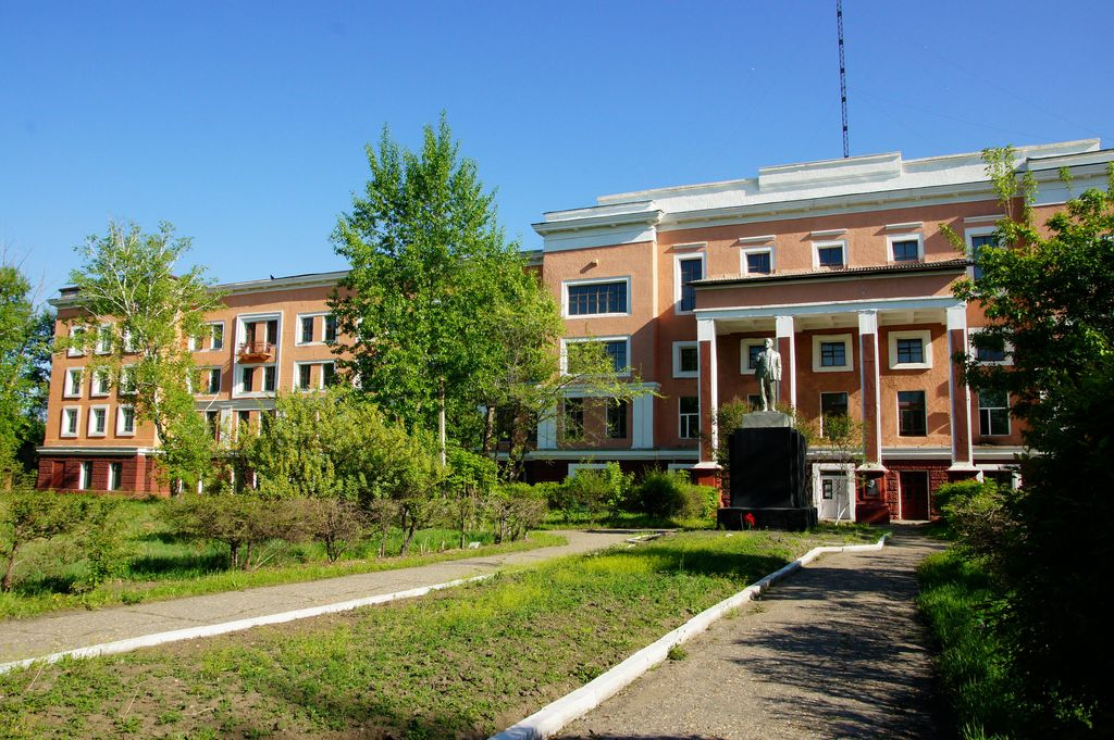


Svobodnyy, Russia
Свободный
Svobodnyy is a town of 61,017 people in Amur Oblast, Russia, founded in 1912.
Why visit Svobodnyy
Townapedia lists 4 museums and landmarks, 5 parks and trails, 23 places to eat, 3 places to stay and 2 attractions in and around town.
Weather in Svobodnyy
Forecast from MET Norway (CC BY 4.0). Full forecast
About Svobodnyy
Svobodny (Russian: Свободный) is a town in Amur Oblast, Russia, located on the right bank of the Zeya River, 167 kilometers (104 mi) north of Blagoveshchensk, the administrative center of the oblast. Population: 58,778 (2010 census); 63,889 (2002 Census); 80,006 (1989 Soviet census).
From the Wikipedia article Svobodny, Amur Oblast (this version), under CC BY-SA 4.0.
Things to do2

Museums and landmarks4

Parks, trails and playgrounds5



Restaurants and cafes23




11 more on the map.
History
It was founded in 1912 in conjunction with the construction of the Amur Railway (the Trans-Siberian Railway's "bypass" route, which was to provide a railway connection from European Russia to the Pacific entirely over the Russian soil, without crossing the north-eastern China). It was originally named Alexeyevsk (Алексеевск), in honor of the then crown prince Alexey. In 1917, the town was renamed Svobodny, Russian for "free".
During the chaos of the Russian Civil War, the Russian Far East became a base for several Korean militias and political groups opposed to the Japanese colonization of Korea. They moved into Svobodny in early 1921, but in the summer factional disputes within the Korean Communist Party and the wider Korean nationalist movement broke out into open warfare, the Free City Incident. The Red Army besieged and then destroyed the town, securing victory for its preferred faction.
During the Stalin era, the BAMLag forced labor camp of the Gulag was built in Svobodny, with the intention of providing forced labor for the planned construction of the Baikal-Amur Mainline. The camp became one of the largest in Gulag system; its peak headcount was about 201,000 (1938). In 1938 it was dismantled into several camps.
From the History section of Svobodny, Amur Oblast on Wikipedia, under CC BY-SA 4.0.
Where to stay3
Churches and places of worship1
Shopping11
Gas and EV charging4
Schools, colleges and libraries8
Healthcare15
Map of Svobodnyy
76 places. The map loads OpenStreetMap tiles when you open it.
Getting there and nearby towns
Ignatyevo Airport (BQS) is the nearest airport with scheduled flights listed in OpenStreetMap, 117 km away.
- Seryshevo 35 km southeast, about 35 min by car
- Polyana 39 km southeast, about 39 min by car
- Tsiolkovskiy 44 km north, about 44 min by car
- Belogorsk 58 km southeast, about 58 min by car
- Shimanovsk 77 km northwest, about 1 h 15 min by car
- Srednebelaya 80 km south, about 1 h 15 min by car
Drive times are estimates from straight-line distance, not routes.
Local news
Headlines from INDB.
Reviews, tips and questions
Loading what members have shared...
Sources and licences
- GeoNames (CC BY 4.0): population, coordinates, regions and time zone
- OpenStreetMap contributors (ODbL 1.0): places, airports, map data
- Wikidata (CC0 1.0): elevation, founding date, time zone, website
- Wikimedia Commons (see each image): photos
- Wikipedia (CC BY-SA 4.0): overview and history text
Photo credits
- Railway college in Svobodny, svb28ru, CC BY-SA 2.0
- Amur pine cone. Svobodny city 2020. Sosnovy Bor(Амурская сосновая шишка. город Свободный 2020. Сосновый бор), Chursaev13, CC BY 4.0
- Orange tree. Svobodny city 2020. Sosnovy Bor(Дерево апельсин. город Свободный 2020. Сосновый бор), Chursaev13, CC BY 4.0
- Railway station in Svobodny, svb28ru, CC BY-SA 2.0
- 자유시기차역, Hyun616, CC BY-SA 4.0
- Железнодорожный вокзал города Свободный (48041484093), Victoria Abrosimova from Khabarovsk, Russia, CC BY 2.0
- 20040728 184231 July 2004 in Russia, Rakoon, CC0
- Nature takes its toll 2. Amur region. Blagoveshchensk 09.2021(Природа берет свое 2. Амурская область. Благовещенск 09.2021), Chursaev13, CC BY 4.0
- Time and nature. Amur region. Blagoveshchensk 09.2021(Время и природа. Амурская область. Благовещенск 09.2021), Chursaev13, CC BY 4.0
- The web of life. Free city 2020. Swamp (Паутина жизни. город Свободный 2020. Болото), Chursaev13, CC BY 4.0
- 자유시참변 미하일로 체스나코프스카야 기차역, Hyun616, CC BY-SA 4.0
- 미하일로 체스나코프스카야 기차역, Hyun616, CC BY-SA 4.0
- Spruce is not according to the standard. Svobodny city 2020. Sosnovy Bor(Ель - не по стандарту. город Свободный 2020. Сосновый бор), Chursaev13, CC BY 4.0
- 자유시 참변 현장 급수탑, Hyun616, CC BY-SA 4.0
- 수라제프카구역, Hyun616, CC BY-SA 4.0
- 스바보드니 수라제프카 공동묘지, Hyun616, CC BY-SA 4.0
- ISS045-E-27929 - View of Earth, Earth Science and Remote Sensing Unit , Lyndon B. Johnson Space Center, Public domain
- ISS030-E-17395 - View of Earth, Earth Science and Remote Sensing Unit , Lyndon B. Johnson Space Center, Public domain
- ISS022-E-55497 - View of Earth, Earth Science and Remote Sensing Unit , Lyndon B. Johnson Space Center, Public domain
- 스바보드니 자유시참변 현장, Hyun616, CC BY-SA 4.0
- ISS066-E-37227 - View of Earth, Earth Science and Remote Sensing Unit , Lyndon B. Johnson Space Center, Public domain
- May 2019 Russian Far East 04, travelling_eidolon, CC BY 2.0
- May 2019 Russian Far East 03, travelling_eidolon, CC BY 2.0


Page built November 4, 2026. Spotted a mistake? Tell us or suggest a place.