
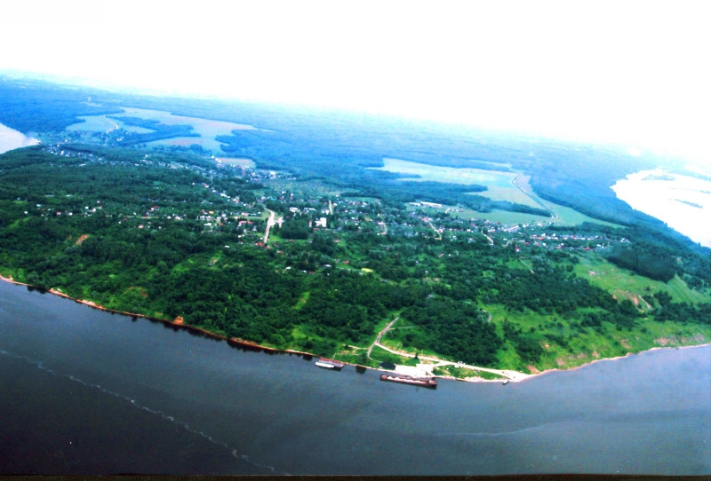


Vasil’sursk, Russia
Васильсурск
Vasil’sursk is a town of 1,038 people in Nizhny Novgorod Oblast, Russia.
Why visit Vasil’sursk
Townapedia lists 2 museums and landmarks, 1 park or trail, 1 place to eat, 1 place to stay and 3 attractions in and around town.
Weather in Vasil’sursk
Forecast from MET Norway (CC BY 4.0). Full forecast
About Vasil’sursk
Vasilsursk (Russian: Васильсу́рск) is an urban locality (a work settlement) in Vorotynsky District of Nizhny Novgorod Oblast, Russia, located on the Sura River, not far from its fall into the Volga.
From the Wikipedia article Vasilsursk (this version), under CC BY-SA 4.0.
Things to do3

Museums and landmarks2

Parks, trails and playgrounds1

Restaurants and cafes1

History
A Kuruk Mari (a tribe of Mari people) wooden fortress named Tsepel used to stand where Vasilsursk is now located. Russians captured it after bloody fight in 1523 from Kuruk Maris and established on its site a small settlement. The fort here was used as an advanced base during the Russo-Kazan Wars.
From the History section of Vasilsursk on Wikipedia, under CC BY-SA 4.0.
Where to stay1
Churches and places of worship1
Map of Vasil’sursk
9 places. The map loads OpenStreetMap tiles when you open it.
Getting there and nearby towns
Cheboksary Airport (CSY) is the nearest airport with scheduled flights listed in OpenStreetMap, 83 km away.
- Vorotynets 12 km southwest, about 12 min by car
- Yadrin 24 km southeast, about 24 min by car
- Yurino 25 km northeast, about 25 min by car
- Spasskoye 36 km southwest, about 36 min by car
- Koz’modem’yansk 40 km northeast, about 40 min by car
- Lyskovo 61 km west, about 1 h by car
- Shumerlya 74 km south, about 1 h 15 min by car
- Novyye Lapsary 75 km east, about 1 h 15 min by car
- Cheboksary 76 km east, about 1 h 15 min by car
- Sergach 76 km southwest, about 1 h 15 min by car
Drive times are estimates from straight-line distance, not routes.
Local news
Headlines from INDB.
Reviews, tips and questions
Loading what members have shared...
Sources and licences
- GeoNames (CC BY 4.0): population, coordinates, regions and time zone
- OpenStreetMap contributors (ODbL 1.0): places, airports, map data
- Wikidata (CC0 1.0): elevation, founding date, time zone, website
- Wikimedia Commons (see each image): photos
- Wikipedia (CC BY-SA 4.0): overview and history text
Photo credits
- Vasilsursk flybird18, Андрей Рубцов, Public domain
- Васильсурск, Flesheater, CC BY-SA 3.0
- Volga - panoramio (2), Alexander Sevastyano…, CC BY-SA 3.0
- Volga near Vasilsursk - panoramio, Alexander Sevastyano…, CC BY-SA 3.0
- В священной роще Арпынгель 04, Ефремов Олег, CC BY-SA 4.0
- В священной роще Арпынгель 02, Ефремов Олег, CC BY-SA 4.0
- В священной роще Арпынгель 01, Ефремов Олег, CC BY-SA 4.0
- Марийская священная сосна, Ефремов Олег, CC BY-SA 4.0
- Марийская священная сосна в Хмелевке, Ефремов Олег, CC BY-SA 4.0
- К Шишкину мысу, Ефремов Олег, CC BY-SA 4.0
- С Шишкина мыса, Ефремов Олег, CC BY-SA 4.0
- Sura river - panoramio, Alexander Sevastyano…, CC BY-SA 3.0
- Волга, Хмелевская церковь - panoramio, Alexander Sevastyano…, CC BY-SA 3.0
- Vorotynsky District, Nizhny Novgorod Oblast, Russia - panoramio (6), Svetlov Artem, CC BY 3.0
- Сигнальные сооружения (как называется^) - panoramio, Евгений Катышев, CC BY-SA 3.0
- Церковь на берегу - panoramio, Евгений Катышев, CC BY-SA 3.0
- Церковь на берегу - panoramio (1), Евгений Катышев, CC BY-SA 3.0
- Sura river, near Vasilsursk - panoramio, Alexander Sevastyano…, CC BY-SA 3.0
- Vorotynsky District, Nizhny Novgorod Oblast, Russia - panoramio, Alexander Sevastyano…, CC BY-SA 3.0
- Vorotynsky District, Nizhny Novgorod Oblast, Russia - panoramio (2), Alexander Sevastyano…, CC BY-SA 3.0
- Vorotynsky District, Nizhny Novgorod Oblast, Russia - panoramio (1), Alexander Sevastyano…, CC BY-SA 3.0
- X-rays - panoramio, Alexander Sevastyano…, CC BY-SA 3.0


Page built November 4, 2026. Spotted a mistake? Tell us or suggest a place.