


Why visit Ruston
Townapedia lists 42 museums and landmarks, 24 parks and trails, 28 places to eat, 1 place to stay and 11 attractions in and around town.
Highlights include Point Defiance Zoo & Aquarium, Browns Point Light, Fort Nisqually and Tacoma Narrows Bridge.
August is the warmest month, with average highs of 76°F; December lows average 36°F.
Weather in Ruston
Forecast from the National Weather Service. Full forecast
About Ruston
Ruston is a city in Pierce County, Washington, United States. The population was 1,055 at the 2020 census.
From the Wikipedia article Ruston, Washington (this version), under CC BY-SA 4.0.
Things to do11
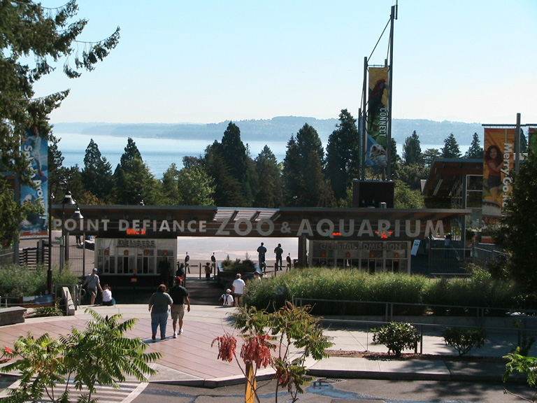
Point Defiance Zoo & Aquarium
Zoo and aquarium · 0.7 mi
Zoo in the United States
5400 North Pearl Street, Tacoma
09:00-17:00

Browns Point Light
Lighthouse · National Register of Historic Places · 3.2 mi
Lighthouse in Washington, United States

North 21st Street Bridge
Bridge · National Register of Historic Places · 2.8 mi
Historic bridge in Tacoma, Washington, United States

Tacoma Narrows Bridge (2007)
Bridge · 2.8 mi
Suspension bridge that span the Tacoma Narrows strait of Puget Sound in Pierce County, Washington



Museums and landmarks42

Fort Nisqually
Monument and historic site · National Register of Historic Places · 1.1 mi
An important fur trading and farming post of the Hudson's Bay Company

Tacoma Narrows Bridge
Monument and historic site · National Register of Historic Places · 2.8 mi
Suspension bridge that collapsed in 1940

Engine House No. 13
Monument and historic site · National Register of Historic Places · 2.2 mi
Historic firehouse in Tacoma, Washington state, USA

Engine House No. 9
Monument and historic site · National Register of Historic Places · 3.4 mi
Fire station in Washington, United States of America

Fire Station No. 14
Monument and historic site · National Register of Historic Places · 1.0 mi
Fire station in Tacoma, United States of America

Fireboat No. 1
Monument and historic site · National Register of Historic Places · 1.8 mi
Museum ship in the United States

North 23rd Street Bridge
Bridge · National Register of Historic Places · 2.7 mi
Historic bridge in Tacoma, Washington, United States

North Slope
Monument and historic site · National Register of Historic Places · 3.4 mi
Human settlement in Tacoma, Washington, United States of America

Rhodes House
Monument and historic site · National Register of Historic Places · 3.3 mi
Historic house in Washington, United States

William Ross Rust House
Monument and historic site · National Register of Historic Places · 3.2 mi
House in Tacoma, Washington, USA

Winnifred Street Bridge
Bridge · National Register of Historic Places
Bridge in United States of America

Puget Sound Museum of Natural History
Museum · 2.7 mi
Natural history museum in Tacoma, Washington, United States
30 more on the map.
Parks, trails and playgrounds24



Ruston Way Park
Park · 0.6 mi
Park in Tacoma, Washington, United States

12 more on the map.
Restaurants and cafes28

Anthony's at Point Defiance
Restaurant · Seafood · 0.7 mi
5910 North Waterfront Drive, Tacoma
Mo-Th 11:00-21:30; Fr-Sa 11:00-22:30; Su 10:00-21:30
WildFin American Grill - Tacoma
Restaurant · American, Seafood
5115 Grand Loop, Tacoma
Mo-Th 11:00-22:00; Sa 09:30-23:00; Fr 11:00-23:00; Su 09:30-22:00

Delightful Neighborhood Market
Cafe · Coffee Shop, Sandwich, Pastry · 0.7 mi
Serving North End Tacoma. Craft Beer. Cafe. Growler Fill Station. Great wine selection. Local Coffee Roasters. Local Sandwiches....
4818 North 45th Street, Tacoma
16 more on the map.
History
In 1890, industrialist William R. Rust established Tacoma Smelting & Refining Company and a company town named the "Smelter District". The company took over an existing smelter that had opened two years earlier and began refining lead; it expanded to more than 300 employees by 1905, with most living in the Smelter District. In 1906, Rust proposed the creation of a new city, which residents named "Ruston" in his honor. Ruston was officially incorporated as a city on November 10, 1906, surrounded on one side by Commencement Bay and all other sides the city of Tacoma.
The Tacoma Smelting & Refining Company was acquired by the American Smelting and Refining Company (ASARCO) in 1905 and its Ruston facility was converted for copper smelting. A prominent brick smokestack was constructed in 1917 and originally measured 571 feet (174 m) in height and was the tallest in the world until it was reduced to 562 feet (171 m) following earthquake damage in 1937. The facility's waste slag was dumped into Commencement Bay for land expansion, while the smokestack produced plumes that polluted portions of Pierce County. The smelter closed in 1985 due to a decline in copper prices and new regulations on arsenic pollution; the facility employed 700 people at the time. The smokestack was demolished on January 17, 1993, amid a major environmental cleanup under the Superfund program.
From the History section of Ruston, Washington on Wikipedia, under CC BY-SA 4.0.
Where to stay1
Silver Cloud Hotel Tacoma Point Ruston Waterfront
Motel and hotel
5125 Grand Loop, Ruston
Churches and places of worship12
St. Peter's Episcopal Church
Church · National Register of Historic Places · 2.7 mi
Saint Lukes Memorial Episcopal Church
Church · Episcopal · 1.3 mi
3615 North Gove Street, Tacoma
Shopping7
Gas and EV charging4
Schools, colleges and libraries43
Bates Technical College - Open Doors
School · 4.3 mi
1101 South Yakima Ave., Tacoma
Healthcare2
Map of Ruston
174 places. The map loads OpenStreetMap tiles when you open it.
Climate by month
Monthly table
| Month | High | Low | Rain |
|---|---|---|---|
| Jan | 46°F | 36°F | 6.1 in |
| Feb | 48°F | 36°F | 4.1 in |
| Mar | 53°F | 38°F | 4.6 in |
| Apr | 58°F | 41°F | 3.4 in |
| May | 64°F | 46°F | 2.1 in |
| Jun | 70°F | 51°F | 1.4 in |
| Jul | 76°F | 54°F | 0.7 in |
| Aug | 76°F | 54°F | 0.9 in |
| Sep | 70°F | 51°F | 1.5 in |
| Oct | 59°F | 46°F | 4.3 in |
| Nov | 50°F | 40°F | 7.2 in |
| Dec | 46°F | 36°F | 5.8 in |
U.S. Climate Normals 1991-2020 for Tacoma Narrows Ap (4 mi away), NOAA NCEI.
People and cost of living
American Community Survey 5-year estimates, 2020-2024, U.S. Census Bureau. Estimates have margins of error, larger for small towns.
Disaster history
Pierce County has had 13 federal disaster declarations since 2000, most often for severe storms.
- 2026-04-07: Severe Storms, Straight-Line Winds, Flooding, Landslides, And Mudslides (Flood)
- 2025-12-12: Severe Storms, Straight-Line Winds, Flooding, Landslides, And Mudslides (Flood)
- 2020-09-09: Sumner Grade Fire (Fire)
- 2020-03-22: Covid-19 Pandemic (Biological)
- 2020-03-13: Covid-19 (Biological)
- 2012-03-05: Severe Winter Storm, Flooding, Landslides, And Mudslides (Severe Storm)
OpenFEMA disaster declarations summaries.
Getting there and nearby towns
Tacoma Narrows Airport (TIW) is the nearest airport with scheduled flights listed in OpenStreetMap, 4 miles away.
- Tacoma 4 mi southeast, about 6 min by car
- Gig Harbor 5 mi northwest, about 8 min by car
- University Place 6 mi south, about 10 min by car
- Rosedale 6 mi northwest, about 10 min by car
- Artondale 7 mi west, about 11 min by car
- Fox Island 7 mi southwest, about 11 min by car
- Canterwood 7 mi northwest, about 11 min by car
- Federal Way 8 mi east, about 13 min by car
- Lakewood 9 mi south, about 15 min by car
- Fife 9 mi southeast, about 14 min by car
Drive times are estimates from straight-line distance, not routes.
Local news
Headlines from INDB, the NEMICO news database.
Reviews, tips and questions
Loading what members have shared...
Sources and licences
- NCES EDGE (Public domain): public schools
- NOAA NCEI U.S. Climate Normals 1991-2020 (Public domain): climate by month
- OpenFEMA (Public domain): disaster declarations
- OpenStreetMap contributors (ODbL 1.0): places, airports, map data
- U.S. Census Bureau (Public domain): population, income, housing, education, commute
- Wikidata (CC0 1.0): elevation, founding date, time zone, website, landmarks and historic places
- Wikimedia Commons (see each image): photos
- Wikipedia (CC BY-SA 4.0): overview and history text
Photo credits
- Antique Sandwich Company 02, Joe Mabel, CC BY-SA 3.0
- Point Ruston, Turtleey, CC BY-SA 4.0
- Ruston Panorama, Turtleey, CC BY-SA 4.0
- Ruston, WA, USA - panoramio, Kira Picabo, CC BY 3.0
- Desolate old Goldfish Tavern in Ruston - panoramio, Kira Picabo, CC BY 3.0
- Ruston park pond - panoramio, Kira Picabo, CC BY 3.0
- Point Ruston Historic Ferry (2022-02-13) , 06, Steven Pavlov, CC BY-SA 4.0
- Point Ruston Historic Ferry (2022-02-13) , 01, Steven Pavlov, CC BY-SA 4.0
- Point Ruston Historic Ferry (2022-02-13) , 03, Steven Pavlov, CC BY-SA 4.0
- Point Ruston Historic Ferry (2022-02-13) , 02, Steven Pavlov, CC BY-SA 4.0
- PDZA Entrance, Takinzinnia, CC0
- Opening day of the Tacoma Narrows Bridge, Tacoma, Washington, University of Washington Libraries Digital Collections, Public domain
- The Fort Nisqually Granary, Steven Pavlov, CC BY-SA 3.0
- North Slope Historic District, Ben Cody, Public domain
- Engine House No. 9, Ben Cody, Public domain
- Browns Point Light (2011), Steven Pavlov, CC BY-SA 4.0
- Winnifred Street Bridge, Ben Cody, Public domain
- Fireboat1-ruston-way-tacoma, Mike Lane, CC BY-SA 3.0
- William Ross Rust House, Ben Cody, Public domain
- Fire Station No. 14, Ben Cody, Public domain
- Henry and Birdella Rhodes House, Ben Cody, Public domain
- North 23rd Street Bridge railing, Ben Cody, Public domain
- St. Peter's Episcopal Church, Ben Cody, Public domain
- North 21st Street Bridge, Ben Cody, Public domain
- Engine House No. 13, Ben Cody, Public domain
- Dalcopassage.from.Owensbeach.looking.north, Crash Dalco, CC BY-SA 3.0
- Tacoma Narrows Bridge 2009, Lderendi, Public domain
- Camp Six Logging Museum 3, Ben Cody, Public domain
- ALPR camera, Tacoma WA USA, 51st and N Shirley Street, Mrdrewk, CC0
- ALPR camera, Novoa, 51st and N Shirley St, Tacoma WA USA, Mrdrewk, CC0
- Where the infamous Asarco plant used to brood, spewing poison all over Tacoma lands and water. Now they're building condos there. - panoramio, Kira Picabo, CC BY 3.0
- Antique Sandwich Company, Steven Pavlov, CC BY-SA 3.0
- West End, Tacoma, WA, USA - panoramio (11), Kira Picabo, CC BY 3.0
- Chinese Christian Church of Tacoma, Steven Pavlov, CC BY-SA 3.0
- 2023-06-01, Manhole cover (Tacoma, Washington), Steven Pavlov, CC BY-SA 4.0
- Neighborhood at Point Defiance, Turtleey, CC BY-SA 4.0
- Ready For A Nap, Dana Hutchinson, CC BY 3.0
- Glossy dreams - panoramio, Kira Picabo, CC BY 3.0
- Zone - panoramio, Kira Picabo, CC BY 3.0
- Shallows - panoramio, Kira Picabo, CC BY 3.0


Page built October 30, 2026. Spotted a mistake? Tell us or suggest a place.