


Sauk Rapids, Minnesota
Sauk Rapids is a city of 13,852 people in Benton County, Minnesota, founded in 1851.
Why visit Sauk Rapids
Townapedia lists 15 museums and landmarks, 17 parks and trails, 51 places to eat, 6 places to stay and 13 attractions in and around town.
Highlights include Bridge of Hope, DeSoto Bridge, Carter Block and Chancery House.
July is the warmest month, with average highs of 82°F; January lows average 3°F, and about 48 inches of snow fall in a normal year.
Weather in Sauk Rapids
Forecast from the National Weather Service. Full forecast
About Sauk Rapids
Sauk Rapids is a city in Benton County, Minnesota, United States. The population was 13,862 at the 2020 census and is 13,896 according to 2021 census estimates, about a third of Benton County's population. It is on a set of rapids on the Mississippi River near its confluence with the Sauk River.
From the Wikipedia article Sauk Rapids, Minnesota (this version), under CC BY-SA 4.0.
Things to do13


Granite City Crossing
Bridge · 2.3 mi
Bridge in United States of America

Old Sartell Bridge
Bridge · 2.9 mi
Bridge in United States of America


Sauk Rapids Regional Bridge
Bridge · 1.0 mi
Bridge in Sauk Rapids, Minnesota

St. Cloud Rail Bridge
Bridge · 2.1 mi
Bridge in United States of America




1 more on the map.
Museums and landmarks15

Carter Block
Monument and historic site · National Register of Historic Places · 2.3 mi
Building in St. Cloud, Minnesota, United States

Chancery House
Monument and historic site · National Register of Historic Places · 2.4 mi
Roman Catholic chancery in St. Cloud, Minnesota, United States
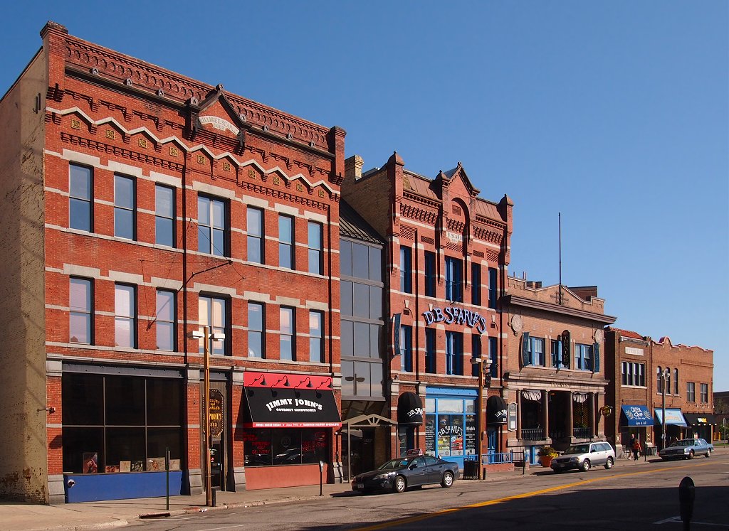
Fifth Avenue Commercial Buildings
Monument and historic site · National Register of Historic Places · 2.4 mi
Historic buildings in St. Cloud, Minnesota, United States

First National Bank
Monument and historic site · National Register of Historic Places · 2.3 mi
Historic bank building in St. Cloud, Minnesota, United States

Foley–Brower–Bohmer House
Monument and historic site · National Register of Historic Places · 2.6 mi
House in St. Cloud, Minnesota, United States

Francis Arnold House
Monument and historic site · National Register of Historic Places · 1.2 mi
House in Stearns County, Minnesota, United States

John N. Bensen House
Monument and historic site · National Register of Historic Places · 2.7 mi
House in St. Cloud, Minnesota, United States

Michael Majerus House
Monument and historic site · National Register of Historic Places · 2.7 mi
House in St. Cloud, Minnesota, United States

Minnesota Correctional Facility – St. Cloud
Monument and historic site · National Register of Historic Places · 4.0 mi
Prison in Minnesota, United States

Nehemiah P. Clarke House
Monument and historic site · National Register of Historic Places · 2.5 mi
House in St. Cloud, Minnesota, United States

Riverview Hall
Monument and historic site · National Register of Historic Places · 3.0 mi
Building at St. Cloud State University, Minnesota, United States


St. Cloud Commercial Historic District
Monument and historic site · National Register of Historic Places · 2.4 mi
Historic district in St. Cloud, Minnesota, United States
3 more on the map.
Parks, trails and playgrounds17

Edgewood Park
Park · 0.8 mi
Community Park with playground and swings.
445 13th Avenue South, Sauk Rapids
5 more on the map.
Restaurants and cafes51

Arroy
Restaurant · Thai · 2.5 mi
800 West Saint Germain Street, St. Cloud
Tu-Fr 11:00-21:00; Sa 10:30-21:00
Mexican Village
Restaurant · Mexican · 2.3 mi
509 West Saint Germain Street, St. Cloud
Mo-Th 11:00-22:00; Fr-Sa 11:00-23:00; Su 11:00-21:30

Iron Street Distillery
Brewery and winery · 1.9 mi
539 East Saint Germain Street
Tu-Th 16:00-19:00;Fr 14:00-23:00;Sa 12:00-23:00;Su 12:00-19:00
The White Horse Restaurant & Bar
Restaurant · 2.5 mi
809 West Saint Germain Street, St. Cloud
Mo-Sa 11:00-22:00

Starbucks
Cafe · Coffee Shop · 2.5 mi
118 6th Avenue South, St. Cloud
Mo-Su 05:00-21:00

B-Side Indie Music Cafe
Cafe · 2.4 mi
27 7th Avenue North
Mo-Fr 07:00-20:00; Sa 08:00-20:00; Su 10:00-15:00
Starbucks
Cafe · Coffee Shop · 1.9 mi
1608 Crossing Loop, Sartell
Mo-Su 05:00-21:00
39 more on the map.
History
Sauk Rapids was originally little more than a forest of oak, maple and basswood trees along the Mississippi River until the first home was constructed there in 1851, a large mansion named Lynden Terrace erected by W.H. Wood. Soon other settlers followed and the town was named Sauk Rapids after the rapids just below the Sauk River's mouth on the Mississippi. The new settlement was along the Red River Trails.
Soon a general store was built, then a hotel, and a large jail. The first settlers organized a church that was soon followed by a Methodist, an Episcopalian and a Lutheran church. The first paper outside of St. Paul was the Sauk Rapids Frontiersman, founded in 1854.
A flour mill was erected in 1875, but was destroyed in 1886. The first bridge was built in 1876, was destroyed later in 1876, and was rebuilt in 1879. The first school was built in 1886.
In 1874, Sauk Rapids was the end of the line for the new railroad. Settlers from as far away as the Red River Valley brought their produce there to ship it. A six-horse stage coach made biweekly trips between St. Cloud and Crow Wing.
In 1856, the county seat moved to Watab, then returned to Sauk Rapids in 1859. A new courthouse was built, but in 1897 the seat moved to Foley, where it remains. In 1917 the courthouse burned down.
From the History section of Sauk Rapids, Minnesota on Wikipedia, under CC BY-SA 4.0.
Where to stay6
Country Inn & Suites, St. Cloud East, MN
Motel and hotel · 2.0 mi
120 Seventh Avenue Southeast, St. Cloud
Churches and places of worship8
Living Waters Lutheran Church ELCA
Church · Lutheran · 1.7 mi
1911 4th Avenue North, Sauk Rapids
Petra Lutheran Church & School WELS
Church · Lutheran · 1.5 mi
1049 1st Avenue North, Sauk Rapids
Sacred Heart Church
Church · Catholic · 1.1 mi
2875 10th Avenue Northeast, Sauk Rapids
The Church of Jesus Christ of Latter-day Saints
Church · Mormon · 2.3 mi
1420 29th Avenue North, St. Cloud
Shopping16
Radio City Music Mall
Shopping center · 2.4 mi
619 West Saint Germain Street, St. Cloud
Gas and EV charging12
Schools, colleges and libraries44
Athlos Academy of Saint Cloud
School · 5.9 mi
3701 33Rd Street South, Saint Cloud
Benton Stearns Education District 1
School · 0.7 mi
324 3Rd Ave South, Sauk Rapids
Benton-Stearns Education District
School · 0.7 mi
324 3Rd Avenue South, Sauk Rapids
Katherine Johnson Education Center
School · 4.0 mi
713 Anderson Avenue North, Saint Cloud
Healthcare9
CentraCare - St. Cloud Medical Group North
Clinic and pharmacy · 2.4 mi
251 County Road 120, St. Cloud
CentraCare Sauk Crossing
Clinic and pharmacy · 2.4 mi
2000 23rd Street South, Sartell
HealthPartners Central Minnesota Clinics
Clinic and pharmacy · 2.5 mi
2251 Connecticut Avenue South, Sartell
Interventional Pain & Physical Medicine Clinic
Clinic and pharmacy · 2.5 mi
2301 Connecticut Avenue South, Sartell
Planned Parenthood
Clinic and pharmacy · 2.0 mi
East Saint Germain Street, St. Cloud
Map of Sauk Rapids
191 places. The map loads OpenStreetMap tiles when you open it.
Climate by month
Monthly table
| Month | High | Low | Rain | Snow |
|---|---|---|---|---|
| Jan | 21°F | 3°F | 0.7 in | 8.8 in |
| Feb | 26°F | 6°F | 0.8 in | 8.9 in |
| Mar | 38°F | 20°F | 1.6 in | 8.2 in |
| Apr | 54°F | 32°F | 2.6 in | 4.7 in |
| May | 68°F | 45°F | 3.7 in | 0.1 in |
| Jun | 77°F | 55°F | 3.8 in | 0.0 in |
| Jul | 82°F | 59°F | 3.6 in | 0.0 in |
| Aug | 79°F | 56°F | 4.0 in | 0.0 in |
| Sep | 71°F | 48°F | 3.0 in | 0.0 in |
| Oct | 56°F | 36°F | 2.6 in | 1.0 in |
| Nov | 39°F | 23°F | 1.4 in | 6.9 in |
| Dec | 26°F | 10°F | 0.9 in | 9.3 in |
U.S. Climate Normals 1991-2020 for St Cloud Rgnl Ap 72655 (6 mi away), NOAA NCEI.
People and cost of living
American Community Survey 5-year estimates, 2020-2024, U.S. Census Bureau. Estimates have margins of error, larger for small towns.
Disaster history
Benton County has had 5 federal disaster declarations since 2000, most often for biologicals.
- 2020-04-07: Covid-19 Pandemic (Biological)
- 2020-03-13: Covid-19 (Biological)
- 2013-07-25: Severe Storms, Straight-Line Winds, And Flooding (Severe Storm)
- 2005-09-13: Hurricane Katrina Evacuation (Hurricane)
- 2001-05-16: Severe Winter Storms, Flooding, And Tornadoes (Flood)
OpenFEMA disaster declarations summaries.
Getting there and nearby towns
Saint Cloud Regional Airport (STC) is the nearest airport with scheduled flights listed in OpenStreetMap, 6 miles away.
- Sartell 3 mi northwest, about 6 min by car
- St. Cloud 5 mi south, about 8 min by car
- Big Lake 26 mi southeast, about 43 min by car
- Monticello 27 mi southeast, about 44 min by car
- Buffalo 32 mi southeast, about 51 min by car
- Elk River 34 mi southeast, about 54 min by car
- Otsego 34 mi southeast, about 55 min by car
- St. Michael 35 mi southeast, about 57 min by car
- Rogers 40 mi southeast, about 1 h by car
- Ramsey 41 mi southeast, about 1 h by car
Drive times are estimates from straight-line distance, not routes.
Local news
Headlines from INDB, the NEMICO news database.
Reviews, tips and questions
Loading what members have shared...
Sources and licences
- NCES EDGE (Public domain): public schools
- NOAA NCEI U.S. Climate Normals 1991-2020 (Public domain): climate by month
- OpenFEMA (Public domain): disaster declarations
- OpenStreetMap contributors (ODbL 1.0): places, airports, map data
- U.S. Census Bureau (Public domain): population, income, housing, education, commute
- Wikidata (CC0 1.0): elevation, founding date, time zone, website, landmarks and historic places
- Wikimedia Commons (see each image): photos
- Wikipedia (CC BY-SA 4.0): overview and history text
Photo credits
- BNSF Railroad and Railway Avenue - Sauk Rapids, Minnesota - Winter (23894354550), Tony Webster from Minneapolis, Minnesota, CC BY-SA 2.0
- Mississippi River Trail and Sauk Rapids Regional Bridge, Minnesota (23511511743), Tony Webster from Minneapolis, Minnesota, CC BY-SA 2.0
- Emergency Tornado Siren - Sauk Rapids, Minnesota (25367993135), Tony Webster from San Francisco, California, CC BY-SA 2.0
- Sauk Rapids Regional Bridge over the Mississippi River, St. Cloud, Minnesota (23510130134), Tony Webster from Minneapolis, Minnesota, CC BY-SA 2.0
- Mississippi River in Winter - Sauk Rapids, Minnesota (24103337052), Tony Webster from Minneapolis, Minnesota, CC BY-SA 2.0
- Mississippi River - Winter in Sauk Rapids, Minnesota (24030263982), Tony Webster from Minneapolis, Minnesota, CC BY-SA 2.0
- Mississippi River in Sauk Rapids, Minnesota - Winter (24042692152), Tony Webster from Minneapolis, Minnesota, CC BY-SA 2.0
- Sauk Rapids, Minnesota, Water Tower (29710697926), Tony Webster from Minneapolis, Minnesota, CC BY-SA 2.0
- Riverview Hall, McGhiever, CC BY-SA 4.0
- Nehemiah P. Clarke House, McGhiever, CC BY-SA 4.0
- Downtown St Cloud, McGhiever, CC BY-SA 4.0
- Foley-Brower-Bohmer House, McGhiever, CC BY-SA 4.0
- Carter Block, McGhiever, CC BY-SA 3.0
- First National Bank, St Cloud MN, McGhiever, CC BY-SA 3.0
- 5th Ave Commercial Buildings, McGhiever, CC BY-SA 3.0
- Stearns County Courthouse, McGhiever, CC BY-SA 3.0
- John N. Bensen House, McGhiever, CC BY-SA 4.0
- Bishop's House–Chancery Office, McGhiever, CC BY-SA 4.0
- 2013-0408-MNCorrectionalFacility–StCloud, Bobak Ha'Eri, CC BY 3.0
- Michael Majerus House, McGhiever, CC BY-SA 4.0
- Pan Motor Co 2, Elkman, CC BY-SA 4.0
- Veterans Bridge, St Cloud, McGhiever, CC BY-SA 3.0
- St. Cloud Rail Bridge, McGhiever, CC BY-SA 3.0
- Oldsaukrapidsbridge, The original uploader was Daveswagon at English Wikipedia ., CC BY-SA 3.0
- Cathedral of St Mary, McGhiever, CC BY-SA 3.0
- Bridge of Hope, Todd Murray, CC BY-SA 3.0
- Sartellbridge2, Daveswagon at English Wikipedia, CC BY-SA 3.0
- Oldsartellbridge1, Daveswagon at English Wikipedia, CC BY-SA 3.0
- SaukRapidsRegionalBridge, The original uploader was Daveswagon at English Wikipedia ., CC BY-SA 3.0
- Granite City Crossing, McGhiever, CC BY-SA 3.0
- DeSoto Bridge, Todd Murray, CC BY-SA 3.0
- Leonard Robinson House, McGhiever, CC BY-SA 3.0
- Mississippi River Sunset - St. Cloud, Minnesota (23894362350), Tony Webster from Minneapolis, Minnesota, CC BY-SA 2.0
- St. Cloud Winter Riverfront - Minnesota (24185300296), Tony Webster from Minneapolis, Minnesota, CC BY-SA 2.0
- Frozen Mississippi River Rock - Winter (24189957705), Tony Webster from Minneapolis, Minnesota, CC BY-SA 2.0
- Francis Arnold House, front path, Garret Jenkins, CC BY-SA 3.0
- Francis Arnold House, Garret Jenkins, CC BY-SA 3.0
- Francis Arnold House 2016, McGhiever, CC BY-SA 4.0
- 65 Dodge Monaco (6089862984), Greg Gjerdingen from Willmar, USA, CC BY 2.0
- 65 Dodge Monaco (6089870004), Greg Gjerdingen from Willmar, USA, CC BY 2.0


Page built October 30, 2026. Spotted a mistake? Tell us or suggest a place.