


Why visit Ramsey
Townapedia lists 15 museums and landmarks, 59 parks and trails, 24 places to eat, 4 places to stay and 3 attractions in and around town.
Highlights include Anoka–Champlin Mississippi River Bridge, Betty Adkins Bridge, Anoka Post Office and Colonial Hall and Masonic Lodge No. 30.
July is the warmest month, with average highs of 83°F; January lows average 4°F, and about 36 inches of snow fall in a normal year.
Weather in Ramsey
Forecast from the National Weather Service. Full forecast
About Ramsey
Ramsey is a suburban city 22 miles (35 km) north-northwest of downtown Minneapolis in Anoka County, Minnesota, United States. The population was 27,646 at the 2020 census. It is a northwest suburb of the Twin Cities.
From the Wikipedia article Ramsey, Minnesota (this version), under CC BY-SA 4.0.
Things to do3

Anoka–Champlin Mississippi River Bridge
Bridge · National Register of Historic Places · 5.5 mi
Highway bridge across the Mississippi River between Anoka, Minnesota and Champlin, Minnesota

Betty Adkins Bridge
Bridge · 5.5 mi
Road bridge across the Mississippi River between Ostego, Minnesota and Elk River, Minnesota

Parrish Avenue Bridge
Bridge · 6.2 mi
Bridge in United States of America
Museums and landmarks15

Anoka Post Office
Monument and historic site · National Register of Historic Places · 5.3 mi
Former post office building in Anoka, Minnesota, United States

Colonial Hall and Masonic Lodge No. 30
Monument and historic site · National Register of Historic Places · 5.4 mi
House in Anoka, United States of America

District No. 28 School
Monument and historic site · National Register of Historic Places · 3.5 mi
Historic school building in Ramsey, Minnesota, United States

Heman L. Ticknor House
Monument and historic site · National Register of Historic Places · 5.5 mi
Historic house in Anoka, Minnesota, United States

Jackson Hotel
Monument and historic site · National Register of Historic Places · 5.3 mi
Listed on the National Register of Historic Places in Anoka County, Minnesota
Oliver H. Kelley Homestead
Monument and historic site · National Register of Historic Places · 4.1 mi
Human settlement in Sherburne County, Minnesota, United States of America
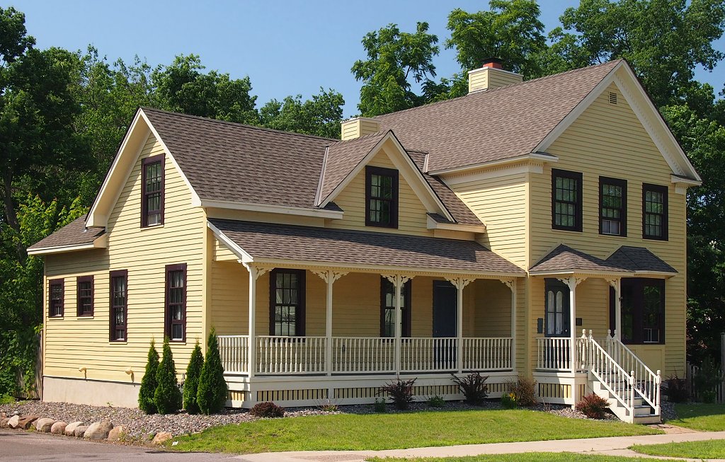
Shaw–Hammons House
Monument and historic site · National Register of Historic Places · 5.1 mi
Oldest standing residential building in Anoka, Minnesota, United States

Windego Park Auditorium/Open Air Theater
Monument and historic site · National Register of Historic Places · 5.2 mi
Amphitheatre in Anoka, United States of America

Sparre Barn
Monument and historic site · National Register of Historic Places · 5.2 mi
Old Ramsey Town Hall
Monument and historic site · 3.5 mi
14120 Saint Francis Boulevard, Ramsey
3 more on the map.
Parks, trails and playgrounds59




Babcock Memorial Park
Park · 5.5 mi
Park in Minnesota, United States of America, United States of America

Reilley West Park
Park · 2.8 mi
5160 156th Lane Northwest, Anoka
Mo-Fr 05:00-22:00

47 more on the map.
Restaurants and cafes24

JR's Outpost
Bar and pub · 3.2 mi
6141 US 10, Ramsey
Mo-We 07:00-25:00; Th-Sa 07:00-26:00; Su 08:00-25:00

China Dragon
Restaurant · Chinese · 1.9 mi
7962 Sunwood Drive Northwest, ramsey
Tu-Th 10:30-21:30; Fr,Sa 10:30-22:00; Su 11:00-21:30


Allison's Petite Pastries Bakery
Bakery · 3.6 mi
14037 Saint Francis Boulevard, Ramsey

12 more on the map.
History
The first settlers in Ramsey were Thomas A. Holmes and James Beatty, who built the Old Log Trading Post in 1849. Itasca Village was platted in 1852. The village contained the first post office in Anoka County and a station on the Northern Pacific Railroad. Itasca Village was abandoned soon after the removal of the Winnebago Indians in the area. In 1857 the first township, Watertown, was created. It was later renamed Dover, and then Ramsey. Ramsey was incorporated on November 12, 1974, with a population of about 8,000 people.
From the History section of Ramsey, Minnesota on Wikipedia, under CC BY-SA 4.0.
Where to stay4
Churches and places of worship8
Independent Baptist Church
Church · Baptist · 1.4 mi
15650 Sunfish Lake Boulevard Northwest, Ramsey
St John The Baptist Church
Church · Catholic · 3.3 mi
18380 Columbus Street, Dayton
Shopping3
Gas and EV charging5
Casey's General Store
Gas station · 2.5 mi
14131 Sunfish Lake Boulevard Northwest, Ramsey
Schools, colleges and libraries32
Healthcare3
Map of Ramsey
156 places. The map loads OpenStreetMap tiles when you open it.
Climate by month
Monthly table
| Month | High | Low | Rain | Snow |
|---|---|---|---|---|
| Jan | 22°F | 4°F | 0.8 in | 8.2 in |
| Feb | 28°F | 7°F | 0.8 in | 7.3 in |
| Mar | 40°F | 18°F | 1.7 in | 6.3 in |
| Apr | 56°F | 32°F | 3.0 in | 2.4 in |
| May | 69°F | 44°F | 4.2 in | 0.0 in |
| Jun | 79°F | 56°F | 4.5 in | 0.0 in |
| Jul | 83°F | 61°F | 4.5 in | 0.0 in |
| Aug | 81°F | 58°F | 4.0 in | 0.0 in |
| Sep | 72°F | 49°F | 3.6 in | 0.0 in |
| Oct | 58°F | 36°F | 3.0 in | 0.2 in |
| Nov | 41°F | 24°F | 1.7 in | 5.3 in |
| Dec | 27°F | 11°F | 1.1 in | 6.0 in |
U.S. Climate Normals 1991-2020 for Elk Rvr (7 mi away), NOAA NCEI.
People and cost of living
American Community Survey 5-year estimates, 2020-2024, U.S. Census Bureau. Estimates have margins of error, larger for small towns.
Disaster history
Anoka County has had 6 federal disaster declarations since 2000, most often for biologicals.
- 2020-04-07: Covid-19 Pandemic (Biological)
- 2020-03-13: Covid-19 (Biological)
- 2011-06-07: Severe Storms And Tornadoes (Severe Storm)
- 2005-09-13: Hurricane Katrina Evacuation (Hurricane)
- 2001-05-16: Severe Winter Storms, Flooding, And Tornadoes (Flood)
- 2000-10-20: Mn - Carlos Edge Fire Complex - 10/19/2000 (Fire)
OpenFEMA disaster declarations summaries.
Getting there and nearby towns
Crystal Airport (MIC) is the nearest airport with scheduled flights listed in OpenStreetMap, 14 miles away.
- Anoka 4 mi southeast, about 7 min by car
- Andover 6 mi east, about 9 min by car
- Champlin 7 mi southeast, about 11 min by car
- Elk River 7 mi northwest, about 12 min by car
- Coon Rapids 9 mi southeast, about 14 min by car
- Otsego 9 mi west, about 14 min by car
- Maple Grove 10 mi south, about 16 min by car
- Brooklyn Park 11 mi southeast, about 18 min by car
- Blaine 13 mi southeast, about 22 min by car
- Ham Lake 13 mi east, about 20 min by car
Drive times are estimates from straight-line distance, not routes.
Local news
Headlines from INDB, the NEMICO news database.
Reviews, tips and questions
Loading what members have shared...
Sources and licences
- NCES EDGE (Public domain): public schools
- NOAA NCEI U.S. Climate Normals 1991-2020 (Public domain): climate by month
- OpenFEMA (Public domain): disaster declarations
- OpenStreetMap contributors (ODbL 1.0): places, airports, map data
- U.S. Census Bureau (Public domain): population, income, housing, education, commute
- Wikidata (CC0 1.0): elevation, founding date, time zone, website, landmarks and historic places
- Wikimedia Commons (see each image): photos
- Wikipedia (CC BY-SA 4.0): overview and history text
Photo credits
- Ramsey Municipal Center, 123dieinafire ( talk ), Public domain
- Ramsey Station at the COR - Metro Transit Northstar Line (29316015420), Tony Webster from Minneapolis, Minnesota, CC BY-SA 2.0
- Ramsey Historic Town Hall, Bradinator33, CC BY-SA 4.0
- Ramsey Town Hall, McGhiever, CC BY-SA 3.0
- TownHallRamseyMN, Jonathunder, GFDL 1.2
- Windego Park 1, Elkman, CC BY-SA 3.0
- Anoka-Champlin Bridge, McGhiever, CC BY 4.0
- Heman L. Ticknor House, McGhiever, CC BY-SA 4.0
- Anoka Post Office, McGhiever, CC BY-SA 4.0
- Shaw-Hammons House 2013, McGhiever, CC BY-SA 3.0
- Jackson Hotel, McGhiever, CC BY-SA 3.0
- Colonial Hall and Masonic Lodge No 30, McGhiever, CC BY-SA 3.0
- Sparre Barn, McGhiever, CC BY-SA 4.0
- Betty Adkins Bridge, Mdcastle at English Wikipedia, CC BY-SA 3.0
- Highway 14 Elk River Bridge, Mdcastle at English Wikipedia, CC BY-SA 3.0
- BabcockParkPump, Jonathunder, GFDL 1.2
- Subaru WRX (VA) front view (United States), Greg Gjerdingen, CC BY 2.0
- Mitsubishi Lancer Evolution X front view (United States), Greg Gjerdingen, CC BY 2.0
- Mitsubishi Lancer Evolution X front view (United States) (2), Greg Gjerdingen, CC BY 2.0
- Mitsubishi Lancer Evolution X DSC08352, Greg Gjerdingen, CC BY 2.0
- Mitsubishi Evo IX DSC08402, Greg Gjerdingen, CC BY 2.0
- Mitsubishi Montero (third generation, United States), Greg Gjerdingen, CC BY 2.0
- Mitsubishi Evo X rear DSC08497, Greg Gjerdingen, CC BY 2.0
- Mitsubishi Evo X rear DSC08497 (cropped), Greg Gjerdingen, CC BY 2.0
- Mitsubishi Lancer Evolution IX DSC08433, Greg Gjerdingen, CC BY 2.0
- Mitsubishi Lancer Evolution IX DSC08433 (2), Greg Gjerdingen, CC BY 2.0
- Mitsubishi Evo X DSC08480, Greg Gjerdingen, CC BY 2.0
- Panorama of the back yard - panoramio, Andrew Balfour, CC BY 3.0
- District No. 28 School, Tiggr222, CC BY-SA 4.0
- District 28 School 3, Elkman, CC BY-SA 3.0
- DecoPac Headquarters in Anoka, Minnesota, Scott Fillman, CC BY-SA 4.0
- ISS008-E-15279 - View of Iowa, Earth Science and Remote Sensing Unit , Lyndon B. Johnson Space Center, Public domain
- ISS059-E-38310 - View of Earth, Earth Science and Remote Sensing Unit, NASA Johnson Space Center, Public domain
- ISS034-E-40509 - View of Earth, Earth Science and Remote Sensing Unit , Lyndon B. Johnson Space Center, Public domain
- ISS054-E-51063 - View of Earth, Earth Science and Remote Sensing Unit, NASA Johnson Space Center, Public domain
- ISS054-E-51064 - View of Earth, Earth Science and Remote Sensing Unit, NASA Johnson Space Center, Public domain
- ISS015-E-16829 - View of Earth, Earth Science and Remote Sensing Unit , Lyndon B. Johnson Space Center, Public domain
- ISS054-E-50212 - View of Earth, Earth Science and Remote Sensing Unit, NASA Johnson Space Center, Public domain
- ISS054-E-50211 - View of Earth, Earth Science and Remote Sensing Unit, NASA Johnson Space Center, Public domain
- Porter Kelsey House, McGhiever, CC BY-SA 4.0


Page built October 30, 2026. Spotted a mistake? Tell us or suggest a place.