




Why visit Sausalito
Townapedia lists 18 museums and landmarks, 40 parks and trails, 51 places to eat, 6 places to stay and 9 attractions in and around town.
Highlights include Fort Point Light, San Francisco, Golden Gate Bridge, Bay Model Visitor Center and Benjamin and Hilarita Lyford House.
September is the warmest month, with average highs of 70°F; January lows average 47°F.
Weather in Sausalito
Forecast from the National Weather Service. Full forecast
About Sausalito
Sausalito (Spanish for "small willow grove") is a city in Marin County, California, United States, located 1.5 miles (2.4 kilometers) southeast of Marin City, 8 miles (13 km) south-southeast of San Rafael, and about 4 miles (6 km) north of San Francisco from the Golden Gate Bridge.
From the Wikipedia article Sausalito, California (this version), under CC BY-SA 4.0.
Things to do9

Fort Point Light, San Francisco
Lighthouse · 3.4 mi
Lighthouse in California, United States

Golden Gate Bridge
Bridge · 2.8 mi
Suspension bridge on the San Francisco Bay

Lime Point Light
Lighthouse · 2.4 mi
Lighthouse below the Golden Gate Bridge, California

Point Diablo Light
Lighthouse · 2.7 mi
Lighthouse in California, United States


Museums and landmarks18

Bay Model Visitor Center
Museum · 0.4 mi
A surviving building from Marinship WWII Shipyard. Not eligible for listing on the National or California Registry of Historic Places.
2100 Bridgeway, Sausalito
Tu-Fr 09:00-15:00; Sa 09:00-16:00

Benjamin and Hilarita Lyford House
Monument and historic site · National Register of Historic Places · 2.5 mi
Historic house in California, United States

Fort Point National Historic Site
Monument and historic site · National Register of Historic Places · 3.4 mi
National Park Service unit in California

Forts Baker, Barry, and Cronkhite
Monument and historic site · National Register of Historic Places · 2.0 mi
Group of historic sites in California

Sausalito Woman's Club
Monument and historic site · National Register of Historic Places · 0.7 mi
Historic building in Sausalito, California, United States
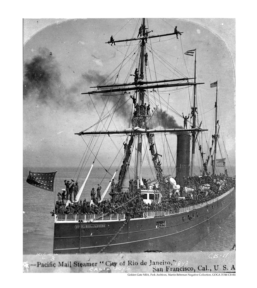
SS City of Rio de Janeiro
Monument and historic site · National Register of Historic Places · 3.1 mi
American passenger ship built in 1878; sank in 1901

William G. Barrett House
Monument and historic site · National Register of Historic Places · 0.6 mi
Historic house in Sausalito, California, United States

ART Industrial Center Building
Monument and historic site · 0.8 mi
A surviving building from Marinship WWII Shipyard. Appears eligible for listing on California Registry of Historic Places.
480 Gate 5 Road, Sausalito

Tiburon Railroad & Ferry Depot Museum
Monument and historic site · National Register of Historic Places · 2.4 mi
Brig Matthew Turner
Monument and historic site · 0.5 mi
Educational Tall Ship, now Call of the Sea, set out to construct a historic and sustainable wooden tall ship, Matthew Turner, for the...
60 Liberty Ship Way, Sausalito
Headlands Center for the Arts
Museum · 2.6 mi
Non-profit organization in the USA

6 more on the map.
Parks, trails and playgrounds40




The Marine Mammal Center
Park · 2.7 mi
Non-profit organization in the USA

28 more on the map.
Restaurants and cafes51

Joinery
Restaurant · Regional · 0.4 mi
A traditional beer hall and restaurant.
300 Turney Street, Sausalito
Mo-Su 11:00-20:00
Le Garage Bistro
Restaurant · French, Bistro · 0.4 mi
85 Liberty Ship Way, Sausalito
Mo-Th 11:30-20:00; Fr 11:30-20:30; Sa 10:00-14:30, 17:00-20:30; Su...
Murray Circle Restaurant
Restaurant · Regional · 1.6 mi
602 Murray Circle, Sausalito
Mo-Th 07:00-11:00,11:30-14:00,17:30-21:00; Fr...
Osteria Divino
Restaurant · Italian · 0.4 mi
Evenings - Authentic Florentine Cuisine Morning espresso and breakfast.
37 Caledonia Street, Sausalito
Mo-Tu off; We-Th,Su 17:00-21:00; Fr-Sa 17:00-22:00
Salito's Crab House and Prime Rib
Restaurant · Seafood · 0.4 mi
1200 Bridgeway, Sausalito
Mo-Su 12:00-20:00

Sausalito Equator
Cafe · Coffee Shop, Cafe, Brunch · 0.4 mi
1201 Bridgeway, Sausalito
Mo-Fr 07:30-17:00; Sa-Su 07:30-17:00
Sausalito Gourmet Delicatessen
Restaurant · Deli, Sandwich
209 Caledonia Street, Sausalito
Mo-Su 11:00-18:00
Scoma's
Restaurant · Seafood · 0.8 mi
588 Bridgeway, Sausalito
Su-Mo, We-Th 11:30-20:00; Fr-Sa 11:30-21:00
Sushi Ran
Restaurant · Sushi
107 Caledonia Street
Su-Th 11:45-14:30, 17:00-22:00; Fr 11:45-14:30, 17:00-23:00; Sa 17:00-23:00
Avatar's
Restaurant · Indian · 0.9 mi
2656 Bridgeway, Sausalito
Mo-Sa 11:00-15:00,17:00-21:30
39 more on the map.
Where to stay6
Churches and places of worship5
Old Saint Hilary’s Church
Church · National Register of Historic Places · 2.4 mi
Shopping33
Gas and EV charging5
Schools, colleges and libraries47
Healthcare2
Map of Sausalito
216 places. The map loads OpenStreetMap tiles when you open it.
Climate by month
Monthly table
| Month | High | Low | Rain |
|---|---|---|---|
| Jan | 58°F | 47°F | 4.4 in |
| Feb | 60°F | 48°F | 4.4 in |
| Mar | 62°F | 49°F | 3.1 in |
| Apr | 63°F | 50°F | 1.6 in |
| May | 64°F | 51°F | 0.7 in |
| Jun | 66°F | 53°F | 0.2 in |
| Jul | 66°F | 54°F | 0.0 in |
| Aug | 68°F | 56°F | 0.1 in |
| Sep | 70°F | 56°F | 0.1 in |
| Oct | 70°F | 54°F | 0.9 in |
| Nov | 64°F | 51°F | 2.6 in |
| Dec | 58°F | 47°F | 4.8 in |
U.S. Climate Normals 1991-2020 for San Francisco Dwtn (7 mi away), NOAA NCEI.
People and cost of living
American Community Survey 5-year estimates, 2020-2024, U.S. Census Bureau. Estimates have margins of error, larger for small towns.
Disaster history
Marin County has had 12 federal disaster declarations since 2000, most often for severe storms.
- 2023-04-03: Severe Winter Storms, Straight-Line Winds, Flooding, Landslides, And Mudslides (Severe Storm)
- 2023-01-14: Severe Winter Storms, Flooding, Landslides, And Mudslides (Flood)
- 2023-01-09: Severe Winter Storms, Flooding, And Mudslides (Flood)
- 2020-03-22: Covid-19 Pandemic (Biological)
- 2020-03-13: Covid-19 (Biological)
- 2019-05-17: Severe Winter Storms, Flooding, Landslides, And Mudslides (Severe Storm)
OpenFEMA disaster declarations summaries.
Getting there and nearby towns
San Rafael Airport (SRF) is the nearest airport with scheduled flights listed in OpenStreetMap, 11 miles away.
- Marin City 1 mi northwest, about 2 min by car
- Belvedere 2 mi northeast, about 3 min by car
- Tamalpais-Homestead Valley 3 mi northwest, about 5 min by car
- Alto 4 mi northwest, about 6 min by car
- Mill Valley 4 mi northwest, about 7 min by car
- Corte Madera 5 mi north, about 8 min by car
- Larkspur 6 mi north, about 10 min by car
- Kentfield 6 mi northwest, about 10 min by car
- San Rafael 9 mi north, about 14 min by car
- Richmond 10 mi northeast, about 16 min by car
Drive times are estimates from straight-line distance, not routes.
Local news
Headlines from INDB, the NEMICO news database.
Reviews, tips and questions
Loading what members have shared...
Sources and licences
- NCES EDGE (Public domain): public schools
- NOAA NCEI U.S. Climate Normals 1991-2020 (Public domain): climate by month
- OpenFEMA (Public domain): disaster declarations
- OpenStreetMap contributors (ODbL 1.0): places, airports, map data
- U.S. Census Bureau (Public domain): population, income, housing, education, commute
- Wikidata (CC0 1.0): elevation, founding date, time zone, website, landmarks and historic places
- Wikimedia Commons (see each image): photos
- Wikipedia (CC BY-SA 4.0): overview and history text
Photo credits
- Sausalito, en:User:Squirrel 22, Public domain
- 100 3335, Tmork08, CC BY-SA 3.0
- CA-boys-on-board-the-city-of-rio-de-janeiro-mail-steamer-1898, newspaper unknown, Public domain
- Lyford House, Tiburon, Frank Schulenburg, CC BY-SA 3.0
- Fort-Baker-Sausalito-Florin-WLM-33, Fabrice Florin, CC BY-SA 3.0
- William G Barrett House 156 Bulkley Ave Sausalito CA 3-21-2010 11-59-16 AM, Sanfranman59, CC BY-SA 3.0
- 2016-08-02 Golden Gate Bridge 15, Kingofthedead, CC BY-SA 4.0
- Sausalito Woman's Club 120 Central Ave Sausalito CA 3-21-2010 11-19-55 AM, Sanfranman59, CC BY-SA 3.0
- San Francisco & Northern Pacific Railroad Depot (Tiburon, CA), Sanfranman59, CC BY-SA 3.0
- Lime Point Lighthouse, SW view, Photograph: Radomianin, Public domain
- SsCity of chester photo, courtesy w:San Francisco Maritime National Historic Park , photographer not credited, Public domain
- Point Diablo Light, California, Frank Schulenburg, CC BY-SA 4.0
- GoldenGateBridge-001, Rich Niewiroski Jr., CC BY 2.5
- Rodeo Beach, Fuzheado ( talk ), CC BY-SA 3.0
- Fort Cronkhite (Sausalito, CA), Sanfranman59, CC BY-SA 3.0
- The Marine Mammal Center, Fuzheado ( talk ), CC BY-SA 3.0
- USCAE Bay Model - San Francisco Bay Detail, Something Original, Public domain
- Fort Point Light, San Francisco (2013), Frank Schulenburg, CC BY-SA 3.0

Page built October 30, 2026. Spotted a mistake? Tell us or suggest a place.