
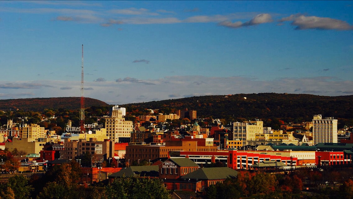


Scranton, Pennsylvania
Scranton is a city of 76,033 people in Lackawanna County, Pennsylvania.
Why visit Scranton
Townapedia lists 93 museums and landmarks, 79 parks and trails, 187 places to eat, 18 places to stay and 24 attractions in and around town.
Highlights include Scranton Cultural Center, Cinemark Montage Mountain 20 and XD, Anthracite Museum and Roger Williams Public School No. 10.
July is the warmest month, with average highs of 85°F; January lows average 20°F, and about 45 inches of snow fall in a normal year.
Weather in Scranton
Forecast from the National Weather Service. Full forecast
About Scranton
Scranton is a second A class city in and the county seat of Lackawanna County, Pennsylvania, United States. With a population of 76,328 at the 2020 census (estimated at 75,514 in 2025), Scranton is the sixth-most populous city in Pennsylvania and the most populous city in Northeastern Pennsylvania. It is part of the Wyoming Valley metropolitan area, which includes five cities and more than 40 boroughs forming a contiguous urban corridor with an estimated 574,000 residents. It is located 56 miles (90 km) north of Allentown, 104 miles (167 km) north-northwest of Philadelphia, and 99 miles (159 km) west-northwest of New York City.
From the Wikipedia article Scranton, Pennsylvania (this version), under CC BY-SA 4.0.
Things to do24

Scranton Cultural Center
Cinema and theater · National Register of Historic Places · 0.6 mi
Theater in Scranton, Pennsylvania, USA
420 North Washington Avenue, Scranton
Cinemark Montage Mountain 20 and XD
Cinema and theater · 3.1 mi
40 Glenmaura National Boulevard, Moosic

Luna Park, Scranton
Monument and historic site · 1.4 mi
Amusement park in Scranton, New Jersey, U.S

Montage Mountain
Ski area · 3.5 mi
Ski resort in Scranton, Pennsylvania, United States
Rocky Glen Park
Monument and historic site · 4.1 mi
Closed entertainment venue in Moosic, Pennsylvania
Toyota Pavilion at Montage Mountain
Cinema and theater · 3.9 mi
Outdoor theater in Scranton, Pennsylvania

University of Scranton
School · 0.6 mi
Private Jesuit university in Scranton, Pennsylvania, USA
The Pavilion at Montage Mountain
Cinema and theater · 3.9 mi
Montage Mountain Road, Scranton

12 more on the map.
Museums and landmarks93


Roger Williams Public School No. 10
Monument and historic site · National Register of Historic Places · 0.7 mi
Heritage building in Scranton, Pennsylvania
901 Prospect Avenue, Scranton

Scranton Iron Furnaces
Monument and historic site · National Register of Historic Places
Historic site in Scranton, Pennsylvania

Steamtown National Historic Site
Monument and historic site · National Register of Historic Places · 0.4 mi
Railroad museum in Scranton, Pennsylvania

Ad-Lin Building
Monument and historic site · National Register of Historic Places · 0.4 mi
Historic commercial building in Scranton, Pennsylvania, United States
Albright Memorial Building
Monument and historic site · National Register of Historic Places · 0.6 mi
Library in Scranton, Pennsylvania

Century Club of Scranton
Monument and historic site · National Register of Historic Places · 0.7 mi
Building in Pennsylvania, United States
Delaware, Lackawanna and Western Railroad Yard-Dickson Manufacturing Co. Site
Monument and historic site · National Register of Historic Places
Historic district in Pennsylvania, United States
Dickson Works
Monument and historic site · National Register of Historic Places · 0.7 mi
Historic industrial building in Scranton, Pennsylvania, United States

Dime Bank Building
Monument and historic site · National Register of Historic Places
Scranton, Pennsylvania
Everhart Museum
Museum · 1.2 mi
Art and natural history museum in Scranton, Pennsylvania, U.S.
1901 Mulberry Street, Scranton
Finch Building
Monument and historic site · National Register of Historic Places · 0.5 mi
Historic place in Pennsylvania, United States
81 more on the map.
Parks, trails and playgrounds79

Nay Aug Park
Park · 1.3 mi
Public park in Scranton, Pennsylvania, United States
500 Arthur Avenue, Scranton
dawn-20:00


McDade Park
Park · 2.6 mi
Community park and arboretum in Scranton and Taylor, Lackawanna County in northeastern Pennsylvania, United States
1 Bald Mountain Road, Scranton
Mo-Su 07:00-dusk



67 more on the map.
Restaurants and cafes187

A'tera 519
Restaurant · Italian, French · 0.4 mi
519 Linden Street, Scranton
Mo-Tu 16:30-22:00, Th-Sa 16:30-23:00, Su 10:00-14:00,16:00-20:00
Alfredo's Pizza Cafe
Restaurant · Pizza · 0.6 mi
1040 South Washington Avenue, Scranton
Su-Th 11:00-21:00; Fr-Sa 11:00-22:00
Chuck E. Cheese
Restaurant · Pizza · 4.2 mi
1003 Commerce Boulevard, Dickson City
Mo-Fr,Su 11:00-21:00; Sa 10:00-22:00
Dino & Francesco's
Restaurant · Italian Pizza · 2.7 mi
3305 Birney Avenue, Moosic
Mo-Sa 10:00-21:00; Su 11:00-21:00
Food & Fire BBQ~Taphouse
Restaurant · Barbecue · 3.0 mi
7041 Shoppes Boulevard, Moosic
Mo-Tu 15:00-21:00; We,Th 12:00-21:00; Fr,Sa 12:00-22:00; Su 12:00-20:00

TGI Fridays
Diner · American · 4.2 mi
620 Scranton Carbondale Highway, Scranton
Mo-Th,Su 11:00-22:00; Fr-Sa 11:00-23:00
Harvest Seasonal Grill & Wine Bar
Restaurant · 3.0 mi
7011 Shoppes Boulevard, Moosic
Mo 15:00-21:00; Tu-Th 11:30-21:00; Fr,Sa 11:30-22:00; Su 11:00-20:00

175 more on the map.
Where to stay18
Courtyard Scranton Montage Mountain
Motel and hotel · 3.0 mi
16 Glenmaura National Boulevard, Scranton
Four Points by Sheraton Scranton
Motel and hotel · 1.0 mi
300 Meadow Avenue, Scranton
Churches and places of worship69
First Church of Christ, Scientist
Church · National Register of Historic Places · 0.4 mi
St. Peter's Cathedral
Church · National Register of Historic Places · 0.5 mi
Basilica of the National Shrine of St. Ann
Church · Roman Catholic · 1.3 mi
Annunciation Greek Orthodox Church
Church · Greek Orthodox · 0.6 mi
505 North Washington Avenue, Scranton
Moosic Alliance Community Church
Church · Christian And Missionary Alliance · 3.6 mi
608 Rocky Glen Road, Avoca
Shopping46
Gas and EV charging26
Schools, colleges and libraries61
Riverside Junior Senior High School
School · 3.2 mi
310 Davis Street, Taylor
Healthcare20
Map of Scranton
250 places. The map loads OpenStreetMap tiles when you open it.
Climate by month
Monthly table
| Month | High | Low | Rain | Snow |
|---|---|---|---|---|
| Jan | 36°F | 20°F | 2.6 in | 11.7 in |
| Feb | 39°F | 22°F | 2.1 in | 10.9 in |
| Mar | 48°F | 29°F | 2.8 in | 10.1 in |
| Apr | 61°F | 39°F | 3.3 in | 0.8 in |
| May | 72°F | 50°F | 3.3 in | 0.0 in |
| Jun | 80°F | 58°F | 3.8 in | 0.0 in |
| Jul | 85°F | 63°F | 3.6 in | 0.0 in |
| Aug | 82°F | 61°F | 3.9 in | 0.0 in |
| Sep | 75°F | 54°F | 4.2 in | 0.0 in |
| Oct | 63°F | 43°F | 3.7 in | 0.7 in |
| Nov | 51°F | 34°F | 2.9 in | 3.2 in |
| Dec | 40°F | 26°F | 2.8 in | 7.7 in |
U.S. Climate Normals 1991-2020 for Wilkes-Barre Intl Ap 72513 (6 mi away), NOAA NCEI.
People and cost of living
American Community Survey 5-year estimates, 2020-2024, U.S. Census Bureau. Estimates have margins of error, larger for small towns.
Disaster history
Lackawanna County has had 13 federal disaster declarations since 2000, most often for severe storms.
- 2020-03-30: Covid-19 Pandemic (Biological)
- 2020-03-13: Covid-19 (Biological)
- 2018-11-27: Severe Storms And Flooding (Severe Storm)
- 2012-10-29: Hurricane Sandy (Hurricane)
- 2011-09-12: Tropical Storm Lee (Flood)
- 2011-09-08: Remnants Of Tropical Storm Lee (Flood)
OpenFEMA disaster declarations summaries.
Getting there and nearby towns
Wilkes-Barre/Scranton International Airport (AVP) is the nearest airport with scheduled flights listed in OpenStreetMap, 6 miles away.
- Dunmore 3 mi east, about 5 min by car
- Kingston 15 mi southwest, about 24 min by car
- Mountain Top 22 mi southwest, about 36 min by car
- Nanticoke 22 mi southwest, about 36 min by car
- Hazleton 35 mi southwest, about 57 min by car
- Berwick 39 mi southwest, about 1 h by car
- Binghamton 50 mi north, about 1 h 15 min by car
- Bloomsburg 50 mi southwest, about 1 h 15 min by car
- Northampton 50 mi south, about 1 h 15 min by car
- Johnson City 52 mi north, about 1 h 30 min by car
Drive times are estimates from straight-line distance, not routes.
Local news
Headlines from INDB, the NEMICO news database.
Reviews, tips and questions
Loading what members have shared...
Sources and licences
- NCES EDGE (Public domain): public schools
- NOAA NCEI U.S. Climate Normals 1991-2020 (Public domain): climate by month
- OpenFEMA (Public domain): disaster declarations
- OpenStreetMap contributors (ODbL 1.0): places, airports, map data
- U.S. Census Bureau (Public domain): population, income, housing, education, commute
- Wikidata (CC0 1.0): elevation, founding date, time zone, website, landmarks and historic places
- Wikimedia Commons (see each image): photos
- Wikipedia (CC BY-SA 4.0): overview and history text
Photo credits
- Scranton, Pennsylvania's skyline- --Scranton, Pennsylvania-- is the largest city in the northeastern part of Pennsylvania- 2014-07-07 21-52, Christopher Seliga, CC BY-SA 3.0
- Scranton Iron Furnaces - Scranton, PA, JJonahJackalope, CC BY-SA 4.0
- Lackawanna Iron historical marker, Scranton, PA, JJonahJackalope, CC BY-SA 4.0
- Plaque at Scranton Iron Furnaces 2, JJonahJackalope, CC BY-SA 4.0
- Plaque at Scranton Iron Furnaces 4, JJonahJackalope, CC BY-SA 4.0
- Plaque at Scranton Iron Furnaces 1, JJonahJackalope, CC BY-SA 4.0
- Plaque at Scranton Iron Furnaces 3, JJonahJackalope, CC BY-SA 4.0
- Plaque at Scranton Iron Furnaces 5, JJonahJackalope, CC BY-SA 4.0
- Scranton Iron Furnaces, Scranton, PA, JJonahJackalope, CC BY-SA 4.0
- Greetings from Scranton, Pennsylvania - Large Letter Postcard (19658620876), Steve Shook from Moscow, Idaho, USA, CC BY 2.0
- Scranton Iron Furnaces in Scranton, PA, JJonahJackalope, CC BY-SA 4.0
- ASM International plaque for the Scranton Iron Furnaces, JJonahJackalope, CC BY-SA 4.0
- Plaques for the Scranton Iron Furnaces, JJonahJackalope, CC BY-SA 4.0
- NRHP plaque for the Scranton Iron Furnaces, JJonahJackalope, CC BY-SA 4.0
- Lackawanna Avenue WB approaching Washington Avenue Scranton PA, Dough4872, CC BY-SA 4.0
- Station in Scranton PA, Jared Kofsky, CC BY-SA 3.0
- Station turned Hotel in Scranton, Jared Kofsky, CC BY-SA 3.0
- Main hall of the Lackawanna Station Hotel, Scranton, PA 2024-07-21, Schwerdf, CC BY 4.0
- US 11 sb, South Scranton, PA (2), July 2023, Mr. Matté (if there is an issue with this image, contact me using this image's Commons talk page , my Commons user talk page , or my English Wikipedia user talk page ; I'll know about it a lot faster), CC BY-SA 4.0
- US 11 sb, South Scranton, PA (1), July 2023, Mr. Matté (if there is an issue with this image, contact me using this image's Commons talk page , my Commons user talk page , or my English Wikipedia user talk page ; I'll know about it a lot faster), CC BY-SA 4.0
- Scranton - Downtown (48472890492), Ajay Suresh from New York, NY, USA, CC BY 2.0
- Woolworth Store in Scranton, Tommyis18, CC BY-SA 2.0
- Lackawanna Station Hotel, Scranton, PA 2024-07-21, Schwerdf, CC BY 4.0
- Spruce & Washington Sts., Scranton, Pennsylvania 2017-05-16, David Wilson, CC BY 2.0
- Scranton - Radisson Lackawanna Station Hotel (48472745076), Ajay Suresh from New York, NY, USA, CC BY 2.0
- 332-334 Lackawanna Avenue, Scranton, Mark Harrell, Public domain
- Scranton - Scranton City Hall (48472742281), Ajay Suresh from New York, NY, USA, CC BY 2.0
- Everhart Museum and Nay Aug Park, Scranton, Pa (79587), The Mebane Greeting Card Co., Wilkes-Barre, PA., Public domain
- McDade Park, Scranton, PA IMG 1552, Billy Hathorn ( talk ), CC BY-SA 3.0
- Steamtown Roundhouse, National Park Service, Public domain
- Roger Williams Public School No 10 Scranton PA, Smallbones, CC0
- Scranton iron furnaces 2008 03 23, Rolfmueller, CC BY-SA 4.0
- Century Club Scranton PA, Smallbones, CC0
- Harrison Avenue Bridge - March 2015, Adam Moss, CC BY-SA 2.0
- Lackawanna County Courthouse Nov 09, Doug Kerr from Albany, NY, United States, CC BY-SA 2.0
- St. Peter's Cathedral, Christopher Seliga, CC BY-SA 3.0
- Ad-Lin bldg Scranton PA, Smallbones, CC0
- Central Railroad of New Jersey Freight Station, Scranton, PA, Daniel Case, CC BY-SA 3.0
- Dime Bank 2 Scranton PA, Smallbones, CC0
- Joseph Cassese House Scranton PA, Smallbones, CC0


Page built October 30, 2026. Spotted a mistake? Tell us or suggest a place.